


Air Temperatures – The following high temperatures (F) were recorded across the state of Hawaii Monday…along with the low temperatures Monday:
79 – 65 Lihue, Kauai
82 – 66 Honolulu, Oahu
79 – 60 Molokai
82 – 58 Kahului AP, Maui
80 – 65 Kailua Kona
81 – 63 Hilo AP, Hawaii
Here are the latest 24-hour precipitation totals (inches) for each of the islands Monday evening:
0.02 Wailua, Kauai
0.03 Waihee Pump, Oahu
0.00 Molokai
0.00 Lanai
0.00 Kahoolawe
0.02 West Wailuaiki, Maui
0.14 Saddle Quarry, Big Island
The following numbers represent the strongest wind gusts (mph) Monday evening:
15 Port Allen, Kauai
18 Kii, Oahu
27 Molokai
18 Lanai
35 Kahoolawe
17 Maalaea Bay, Maui
27 Pali 2, Big Island
Hawaii’s Mountains – Here’s a link to the live webcam on the summit of our tallest mountain Mauna Kea (nearly 13,800 feet high) on the Big Island of Hawaii. Here’s the webcam for the Haleakala Crater on Maui. These webcams are available during the daylight hours here in the islands, and at night whenever there’s a big moon shining down. Also, at night you will be able to see the stars — and the sunrise and sunset too — depending upon weather conditions.
Aloha Paragraphs

High pressure north-northeast of the state

An upper level low far northeast…with a cold front north

Clear to partly cloudy…some cloudy areas

A few showers – Looping image
~~~ Hawaii Weather Narrative ~~~
Small Craft Advisory…Kauai NW waters, Kauai leeward and windward waters, Kauai Channel, Maalaea Bay, Pailolo and Alenuihaha Channels, Big Island leeward and southeast waters (gusty trades and rising NW swell this afternoon)
High Surf Advisory…rising surf north and west shores of Kauai, Oahu, Molokai, and north shores of Maui
Broad Brush Overview: Look for relatively dry trade wind weather conditions through much of this first week of 2018, as high pressure remains in place to our north and northeast. The trades will likely weaken over the state tonight through Tuesday…as a cold front passes by to the north of the state.
Details: Dry and stable conditions are expected, as deep layer high pressure ridging prevails over the state. The leading edge of a minor cloud band will arrive over the windward areas and bring a few showers…with accumulations remaining very limited. This band of clouds should move through by Tuesday…with even drier air following it going into mid-week.
Looking Further Ahead: The models suggest that breezy trades will prevail Wednesday through the second half of the week, as high pressure builds north of the state. Another band of slightly higher moisture associated with a frontal boundary passing to our north, may push in across the islands within the trades Thursday through Friday. Mostly cloudy skies along with scattered light showers may result over windward locations Thursday night into Friday. A similar dry trade wind pattern will follow through next weekend.
Here’s a wind profile of the Pacific Ocean – Closer view of the islands / Here’s the vog forecast animation / Here’s the latest weather map
Marine environment details: A small northwest swell will continue through tonight, with surf remaining well below the High Surf Advisory thresholds along north and west facing shores. A larger northwest swell arriving early Tuesday, is expected to peak late Tuesday, and will likely cause surf to reach the High Surf Advisory criteria along most north and west facing shores of the smaller islands.
The northwest swell is expected to gradually subside late Wednesday through early Friday. The models show a west-northwest swell arriving late Friday. This swell will gradually build through Saturday, with surf heights potentially approaching the High Surf Advisory criteria along some north and west facing shores of the smaller islands late Saturday into Sunday.
Trade wind swell will continue to generate moderate rough surf along east facing shores through next weekend. Typical wintertime conditions are expected to maintain very small surf along south facing shores this new week.
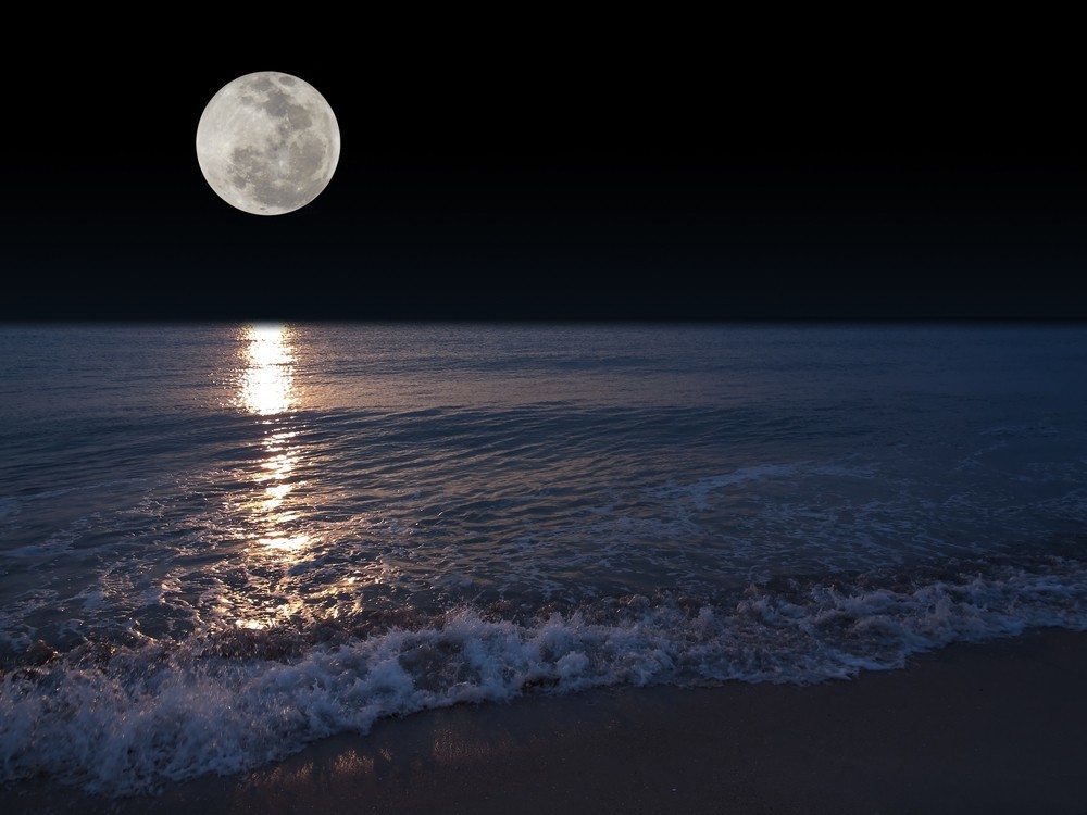
Full Moon
World-wide Tropical Cyclone activity
>>> Here’s the latest PDC Weather Wall Presentation, covering a tropical disturbance being referred to as Invest 94S in the South Indian Ocean…and Tropical Depression 01W near the Philippines
![]()
>>> Atlantic Ocean:
>>> Caribbean Sea:
>>> Gulf of Mexico:
Here’s a satellite image of the Caribbean Sea…and the Gulf of Mexico
Here’s the link to the National Hurricane Center (NHC)
>>> Eastern Pacific:
Here’s a wide satellite image that covers the entire area between Mexico, out through the central Pacific…to the International Dateline.
Here’s the link to the National Hurricane Center (NHC)
>>> Central Pacific:
Here’s a link to the Central Pacific Hurricane Center (CPHC)
>>> Northwest Pacific Ocean:
Tropical Depression 01W
JTWC textual forecast warning
JTWC graphical track map
NOAA satellite image
>>> North and South Indian Oceans / Arabian Sea: No active tropical cyclones
Here’s a link to the Joint Typhoon Warning Center (JTWC)
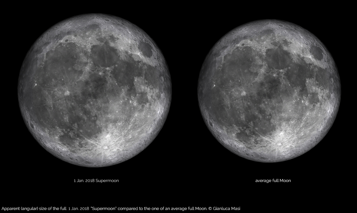
Interesting: New Year’s Day Full Moon: Are ‘Supermoons’ Really That Super? – On this first day of 2018, at 12 p.m. HST, the January full moon will arrive at perigee, its closest point to Earth in an orbit. Today, our lunar companion reaches an extreme perigee distance of 221,559 miles. When these events coincide (a full moon at perigee), some people refer to the event as a “supermoon.”
This will be the “biggest full moon of 2018,” and the difference in the moon’s apparent size, compared with when it is positioned at its average distance from Earth, will be 7.3 percent. But that variation is not readily apparent to observers who are viewing the moon directly.
And then there is the other facet: the oft-cited statistic that the perigee full moon is 30 percent brighter than a “normal” full moon. But that translates to only a 0.1 or 0.2 magnitude difference in brightness. When added to the glow of a full moon, the difference is hardly perceptible to the human eye. (In fact, most observers can’t discern a truly “full” moon from a nearly full moon, and for a day or two before and after peak fullness, many people who see the moon will assume it is full.
Put another way, if you didn’t hear that the New Year’s Day full moon was going to be the biggest and brightest one of the year, would you notice it? Probably not.
Most media outlets love to treat a “supermoon” as some sort of special or unusual occurrence. Upon hearing that a specifically selected moon comes with the prefix “super” attached, people rush outside to get a look and come away thinking that they have just witnessed something akin to a rare cosmic alignment. Such feelings put a new spin on the whimsical tale penned in 1837 by Hans Christian Andersen, “The Emperor’s New Clothes.”
In fact, I once took a phone call at New York’s Hayden Planetarium from a young woman who sounded as though she had been cheated. “I went outside last night to look at that so-called ‘super’ moon and was very much disappointed. It didn’t look at all brighter than normal.” When I queried her on what she had expected to see, she replied, “I thought it was going to be something like those three-way light bulbs. Like when you go from 100 to 150 watts; I thought the moon was going to appear noticeably brighter last night, but it really wasn’t at all!”
Of course, once somebody is told that the moon is closer than normal to Earth and that it will consequently appear somewhat larger, they might respond with something like, “Oh yeah! It does look bigger than normal!” This is especially true if someone sees the moon near to the horizon, where the enigmatic “moon illusion” always comes into play.
A supermoon every month?
If the criteria for a supermoon is chiefly dependent on the moon’s arrival at its closest point in its orbit relative to Earth, then the “super” branding is a bit of a misnomer. Indeed, the moon arrives at perigee every month and sometimes twice in a calendar month. Indeed, now the full moons that immediately flank the Jan. 1 perigean full moon are also being branded as supermoons. The full moon on Dec. 3 was “super,” and the one later this month, on Jan. 31, will be, too. And the margin for a supermoon seems to be widening, as full moons that occur within one or two days of perigee are sometimes given the “super” moniker.
So why can’t we have a supermoon at other phases? This year on Halloween, for instance, the last-quarter moon will come within less than 4 hours of perigee. But nobody ever gets excited about a “super” half-moon.
The popular astrophysicist Neil deGrasse Tyson probably said it best: “In the overall scheme of things, is this relatively small increase in the moon’s apparent size really so meaningful? I mean, if you turned a 14-inch pizza into a 15-inch pizza, would you then call it a “super-pizza?”
maggie Says:
Aloha Glenn, Happy New Year and best wishes for 2018!
Although the weather on New Year’s eve was rather unremarkable, the tranquil conditions offered some spectacular views from upcountry and the higher areas in Wailuk of personal fireworks being set off across the central valley.
I watched the show from a porch in Kula and must say that the experience was more fun than most “organized” fireworks displays. Near midnight, there was a continual burst of color stretching across the entire island from Kehei to Kahului. It doesn’t compare to nature’s fireworks, but was still a delightful experience.
~~~ Oh Maggie, this time a different Maggie! Happy New Year to you as well!
Your New Years Eve experience sounds like fun. I spent the evening here in west Sebastopol, Sonoma County, CA and there was hardly any noise this far out in the rural countryside. I did hear one large boom, and a few shouts, although it all died down quickly.
Northern California is finally going to get some rain Wednesday into Friday, which will be nice. There’s a chance there could even be a thunderstorm or two, which would be great for me. I’ll be back on Maui in a few days, which will be nice.
Best Wishes….
Aloha, Glenn
Maggie Says:
Hi Glenn
Happy New Year to you and yours! Continue to be amazed and appreciative of your weather updates for the islands. thank you for your faithful reporting!
we are heading to Maui for 4 weeks in early May and our son will be joining us for one of the weeks. We have been considering a day trip to either Lanai or Molokai. Would you have a recommendation as to which would be most worthwhile? I am drawn to the history tied to Molokai but any suggestions or advice would be awesome.
thank you
Maggie Campbell
~~~ Hi Maggie, and a Happy New Year to you as well. Thanks for your positive comments about by this website, I enjoy bringing it to you.
As for your question between Lanai and Molokai, I really don’t know. I’ve spent very little time on either island. If I had this question myself, I’d probably do a search on google perhaps. I wish you luck in making the right decision.
I would image both islands have their high points…good luck!
Aloha, Glenn
Susan Says:
Happy 2018 Glenn. Wishing you and your family all goodness and happiness. We’re looking forward to another year of the best weather and information from Hawaii’s best meteorologist! Greetings from Susan and Gary in Waikoloa
~~~ Hi Susan, thanks for your Happy New Years wishes, I appreciate that.
Yes, another year of weather reporting, I’ll be doing that…and I appreciate your generous feedback on my website.
Aloha to you both… Susan and Gary
Glenn
Sandra J Says:
Happy New Year Glenn!! Wishing you and Mama James the very best for 2018!! Thank you for continuing to maintain this website. It’s like getting a little piece of Maui every day, and one can never get enough of Maui.
May 2018 be full of love and laughter. Aloha!!
~~~ Hi Sandra, Happy New Year to you too…thanks for your well wishes for my Mom and I. You’re very welcome, I love keeping this website up-to-date with the latest weather information…I’m happy that it brings you the pleasure of Maui.
Love and Laughter, good things indeed!
Aloha, Glenn