


Air Temperatures – The following maximum temperatures (F) were recorded across the state of Hawaii Monday:
81 Lihue, Kauai
82 Honolulu, Oahu
85 Molokai
84 Kahului, Maui
86 Kona, Hawaii
85 Hilo, Hawaii
Air Temperatures ranged between these warmest and coolest spots near sea level – and on the highest mountain tops on Maui and the Big Island…as of 743pm Monday evening:
Poipu, Kauai – 80
Lihue, Kauai – 72
Haleakala Summit – 48 (near 10,000 feet on Maui)
Mauna Kea Summit – 37 (13,000+ feet on the Big Island)
Hawaii’s Mountains – Here’s a link to the live web cam on the summit of near 13,800 foot Mauna Kea on the Big Island of Hawaii. This web cam is available during the daylight hours here in the islands…and when there’s a big moon shining down during the night at times. Plus, during the nights you will be able to see stars, and the sunrise and sunset too… depending upon weather conditions. Here’s the Haleakala Crater webcam on Maui – if it’s working.
Aloha Paragraphs
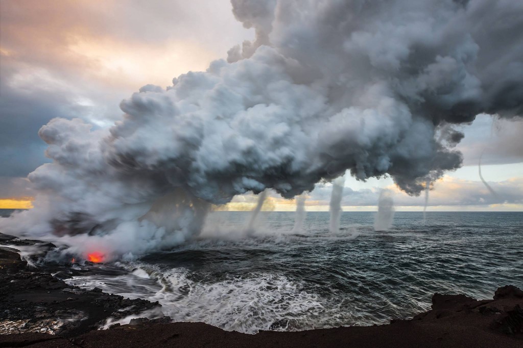
Volcanic Vortices…Big Island / Photo: Bruce Omori
Light south to southeast winds / Limited rainfall / Locally voggy
The following numbers represent the most recent top wind gusts (mph), along with directions as of Monday evening:
11 Waimea Heights, Kauai – SE
13 Wheeler AAF, Oahu – NW
11 Molokai – SE
09 Lanai – SE
10 Kahoolawe – SE
10 Hana, Maui – SE
24 South Point, Big Island – NE
Here are the latest 24-hour precipitation totals (inches) for each of the islands as of Monday evening:
0.58 Port Allen, Kauai
0.56 Kahana, Oahu
0.00 Molokai
0.00 Lanai
0.00 Kahoolawe
0.00 Haiku, Maui
0.05 Kealakomo, Big Island
We can use the following links to see what’s going on in our area of the north central Pacific Ocean. Here’s the latest NOAA satellite picture – the latest looping satellite image… and finally the latest looping radar image for the Hawaiian Islands.
~~~ Hawaii Weather Narrative ~~~
Our local winds will remain light from the south to southeast into Tuesday, then south to southwest through Thursday, briefly north on Friday…then back to trades by the weekend. The lighter breezes will be blowing from the south to southeast into Tuesday, with locally voggy skies. The forecast then calls for Kona winds (south and southwest) to set in Wednesday, lasting for a couple of days. The longer range outlook calls for a brief period of slightly cooler north winds behind a cold front on Friday…veering back to the trade wind direction by the weekend.
There will be a few showers falling locally here and there…although most areas will remain dry through most of Wednesday. Satellite imagery shows lots of bright white clouds over and around the islands…most of which are high level cirrus clouds. These clouds will dim and filter our sunshine at times Tuesday, and our just past full moon tonight. Here’s the looping radar image, showing a few very light showers, although most areas are dry…at the time of this writing. The outlook calls for showers to arrive preceding a cold front Wednesday night into Thursday morning, then the cold front itself pushes down through the state later Thursday into Friday morning.
It will be an interesting week of weather, with light winds, voggy skies, showers at times, and even a chance of a thunderstorm near Kauai…followed by returning trade winds during the upcoming weekend. As the south to southeasterly breezes prevail now, they will be blocked to some degree by the the Big Island. This in turn will put the smaller islands in a wind shadow, which will likely have us feeling a bit warmer than usual…and muggy during the days too. These lighter winds, with onshore flowing daytime sea breezes, will prompt afternoon cloud builds around the mountains during the afternoon hours. The atmosphere will remain drier than normal into mid-week however, although we may see a few light showers falling over the leeward slopes during the afternoon hours…and along the southeast coasts and slopes at night. As we get into the later Wednesday through Friday time frame, our atmosphere will become more unstable, as a cold front approaches from the northwest at the surface, and cold air moves over the state aloft. This will increase the chance of localized showers, with a few being heavy, along with the slight chance of a thunderstorm on the Kauai end of the state. A weak cold front will ride down into the state Thursday, followed by slightly cooler north breezes Friday. As the trade winds return by the weekend, we’ll see showers falling along the windward coasts and slopes. I’ll be back with your next new weather narrative early Tuesday morning. I hope you have a great Monday night wherever you’re spending it! Aloha for now…Glenn.
World-wide tropical cyclone activity:
Atlantic Ocean: Subtropical storm Melissa has formed in the central Atlantic Ocean. Here’s the NHC graphical track map, along with a satellite image. Here’s what the hurricane models are showing for this system.
Here’s a satellite image of the Atlantic Ocean
Caribbean Sea: There are no active tropical cyclones
Gulf of Mexico: There are no active tropical cyclone
Here’s a satellite image of the Caribbean Sea…and the Gulf of Mexico.
Here’s the link to the National Hurricane Center (NHC)
Eastern Pacific: There are no active tropical cyclone
Here’s a wide satellite image that covers the entire area between Mexico, out through the central Pacific…to the International Dateline.
Central Pacific Ocean: There are no active tropical cyclones
Here’s a link to the Central Pacific Hurricane Center (CPHC)
Western Pacific Ocean: There are no active tropical cyclones
South Pacific Ocean: There are no active tropical cyclones
North and South Indian Oceans: There are no active tropical cyclones
Here’s a link to the Joint Typhoon Warning Center (JTWC)
Interesting: Tiny algae signal big changes for warming Arctic lakes. The mighty polar bear has long been the poster child for the effects of global warming in the Arctic, but the microscopic diatom tells an equally powerful story.
Diatoms are a type of algae that form the base of the food chain in watery habitats the world over. Disturbances among lake diatoms have exposed the impacts of rapid warming in the Hudson Bay Lowlands of eastern Canada, researchers reported Oct. 9 in the Proceedings of the Royal Society B.
While other parts of the Arctic began to thaw in the 19th century, the Hudson Bay Lowlands remained stable until about 15 years ago. Since then, the region’s average temperatures have shot up three degrees Celsius.
To gauge the effects of this warming on lowland ecosystems, ecologist John Smol and his team at Queen’s University in Ontario extracted sediment cores from four lakes. Like the rings of a tree trunk, a sediment core is a repository of lake history—a physical record of the dead creatures and other debris that descend to the lake bottom each year. The 30-centimeter-deep cores, encapsulating 200 years of lake history, were littered with intact glass-like diatom shells.
Diatoms preserved in lake sediments are sensitive environmental indicators. As the lowlands warmed up, the researchers found, different diatom varieties began to thrive, including more species that float throughout the water column, rather than sticking to the lake bottom. Distinct temperature layers within the lakes arise as winter ice thins, triggering changes among the diatoms, the scientists believe.
Like an ice bath holding a bottle of champagne, the frozen bay chilled the lowlands for thousands of years, explained ecologist Warwick Vincent of Université Laval in Quebec, who was not part of the study. Once the ice bath began to melt, though, the period of winter ice cover shortened with each passing year. The bay and its lowlands started to lose their cool, further shrinking the ice season in a chain reaction of warming.
On the eastern side of Hudson Bay, Vincent has studied pollen in soil cores to track changes in tree species and has witnessed similar patterns. “You see it’s very, very constant through the millennia, until you get to the 1990s. Then everything changes,” he said.
Milder lake waters have allowed new diatom species to prosper, yielding more energy for the whole food chain. “With climate change, there are winners and losers,” said Smol.
AmandaonMaui Says:
I am totally shocked by this odd shift in the weather. I wonder if it represents larger scale changes for our future due to climate change, or if it’s just a fluke. I could sure do with some cooler weather. It just doesn’t feel like Thanksgiving is right around the corner.~~~Hi Amanda, I’m surprised to hear you use the word shocked. We have south to southeast breezes now, which bring up air from the deeper tropics, which is often warm and humid. We must remember that we live in the tropics. I’m pretty sure you feel quite cool early Tuesday morning, as the down slope breezes coming off the Crater are bringing cool air down towards the ocean. I always enjoy hearing your thoughts, thanks. Aloha, Glenn
Mary Says:
Awesome picture, Glenn, that fits for this muggy, voggy day!~~~Thanks Mary, my thought exactly! Aloha, Glenn