Air Temperatures – The following maximum temperatures were recorded across the state of Hawaii Sunday afternoon:
Lihue, Kauai – 83
Honolulu, Oahu – 86 Kaneohe, Oahu – 84 Kahului, Maui – 87 Hilo, Hawaii – 86
Kailua-kona – 85 Air Temperaturesranged between these warmest and coolest spots near sea level, and on the taller mountains…at 3 p.m. Sunday afternoon:
Kahului, Maui – 87F Lihue, Kauai– 80
Haleakala Crater- missing (near 10,000 feet on Maui)
Mauna Kea summit – 45 (near 14,000 feet on the Big Island) Precipitation Totals – The following numbers represent the largest precipitation totals (inches) during the last 24 hours on each of the major islands, as of Sunday afternoon:
0.55 Mohihi Crossing, Kauai 1.01 Waiawa, Oahu
0.00 Molokai
0.00 Lanai
0.00 Kahoolawe 0.32 Kaupo Gap, Maui
0.12 Waiakea Uka, Big Island Weather Chart – Here’s the latest (automatically updated) weather mapshowing a 1026 millibar high pressure system located far to the northeast of Hawaii…with its associated ridge, now located just north of Kauai…gradually moving northward. This pressure configuration will keep our winds light Monday morning…slowly strengthening into Tuesday. Satellite and Radar Images: To view the cloud conditions we have here in Hawaii, please use the following satellite links, starting off with theInfrared Satellite Image of the islands to see all the clouds around the state during the day and night. This next image is one that gives close images of the islands only during the daytime hours, and is referred to as a Close-up visible image. This next image shows a larger view of the Pacific…giving perspective to the wider ranging cloud patterns in the Pacific Ocean. To help you keep track of where any showers may be around the islands, here’s the latest animatedradar image.
Hawaii’s Mountains – Here’s a link to the live webcam on the summit of near 14,000 footMauna Kea on the Big Island of Hawaii. The tallest peak on the island of Maui is theHaleakala Crater, which is near 10,000 feet in elevation. These two webcams are available during the daylight hours here in the islands…and when there’s a big moon rising just after sunset for an hour or two! Plus, during the nights and early mornings you will be able to see stars, and the sunrise too…depending upon weather conditions.
Aloha Paragraphs
Tonight is the September full moon Photo Credit: flickr.com
Our winds will remain light and variable Sunday…with a tendency towards southeast.These light SE breezes have carried lots volcanic haze up over the islands, from the vents on the Big Island. Sunday will have poor air visibilities, with some of the thickest vog that we’ve seen since the late spring months. The return of trade winds Monday will begin the process of clearing our local atmosphere, but it will likely take until Tuesday before we see greatly improved air quality. The trade winds will continue blowing through the rest of the new week.
The emphasis for showers will be focused over the upcountry interior sections, especially over and around the leeward slopes.A trough of low pressure aloft, which has destabilized our local atmosphere some, especially over Kauai and Oahu…will move away soon. Nonetheless, we will find clouds gathering over and around the mountains on all the islands Sunday afternoon, with some showers falling locally. As the trade winds return soon, the bias for showers will slip back over to the windward sides.
It’s early Sunday afternoon here in Kula, Maui, as I begin writing this last paragraph of today’s tropical weather narrative from Hawaii. Clouds gathered around the mountains Sunday afternoon, with showers falling here and there, at least here in Kula…as I type these words. The beaches have remained mostly sunny, warm, and quite humid. The only place that finds the trade winds blowing at the moment, or at least with any strength…was down at South Point on the Big Island. As you saw in the picture as you were scrolling down the page, tonight is the full moon. This big moon reaches its fullest aspect, here in the islands, at 11:14 p.m. This moon may have a slight muted color to it, as has the sun going down, through the volanic haze the last couple of evenings. At 3pm Sunday afternoon, it was 87F degrees in Kahului, and at the same time, a thick and foggy 66F degrees here in Kula…at the 3,100 foot elevation. It’s an interesting life we’re living now…isn’t it! I’ll be back very early Monday morning with your next new weather narrative. I hope you have a great Sunday night until then! Aloha for now…Glenn. Interesting:
Cutting down on the use of paper is easy enough, but in spite of all your efforts you’ll never become 100% paperless. That’s where tree free paper comes in. Recently launched on the market by GPA, a Chicago paper company, Ultra Green paper is 100% tree free. And of equal importance; the paper is produced without any water. What more can you ask for? This paper is going to be a massive selling point for business leaders vying for deals. Not to speak of green design/advertising. Ultra Green is made from inorganic mineral powders derived from limestone and calcium carbonate, with a trace amount of non-toxic resin and high density polyethylene (HDPE) as a binding agent. No chlorine is used. Sounds too good to be true? There’s more! Ultra Green paper is also won’t yellow or become brittle no matter how long it’s exposed to sunlight. The paper is resistant to scuffing, water, grease and oils and can be used outdoors without being at risk from decomposing.
Plus it offers antimicrobial protection and conforms to FDA standards for food contact! And due to the water and energy savings made in its manufacturing process, Ultra Green paper is priced 30 to 40% below than regular synthetic paper and film. Replacing one ton of traditional paper with one ton of Ultra Green paper saves 20 trees, according to Environmental Defense’spaper calculator. It also eliminates 42 lbs of waterborne waste, 7,480 gallons water/wastewater, 167 lbs solid waste and 236 lbs carbon emissions. Energy savings amount to 25 million BTU. GPA says that the paper combines the printability of a traditional paper product with the durability of a plastic sheet. It does not require special inks or manufacturing processes. This paper ought to be the invention of the year!
Interesting2:
The amount of sea ice around Antarctica has grown in recent Septembers in what could be an unusual side-effect of global warming, experts said on Friday. In the southern hemisphere winter, when emperor penguins huddle together against the biting cold, ice on the sea around Antarctica has been increasing since the late 1970s, perhaps because climate change means shifts in winds, sea currents or snowfall. At the other end of the planet, Arctic sea ice is now close to matching a September 2007 record low at the tail end of the northern summer in a threat to the hunting lifestyles of indigenous peoples and creatures such as polar bears. "The Antarctic wintertime ice extent increased…at a rate of 0.6 percent per decade" from 1979-2006, said Donald Cavalieri, a senior research scientist at the NASA Goddard Space Flight Center. At 19 million sq kms (7.34 million sq mile), it is still slightly below records from the early 1970s of 20 million, he said. The average year-round ice extent has risen too. Some climate skeptics point to the differing trends at the poles as a sign that worries about climate change are exaggerated. However, experts say they can explain the development.
"What’s happening is not unexpected…Climate modelers predicted a long time ago that the Arctic would warm fastest and the Antarctic would be stable for a long time," said Ted Maksym, a sea ice specialist at the British Antarctic Survey. The U.N. Climate Panel says it is at least 90 percent sure that people are stoking global warming — mainly by burning fossil fuels. But it says each region will react differently. A key difference is that Arctic ice floats on an ocean and is warmed by shifting currents and winds from the south. By contrast, Antarctica is an isolated continent bigger than the United States that creates its own deep freeze. "The air temperature in Antarctica has increased very little compared to the Arctic," said Ola Johannessen, director of the Nansen Environmental and RemoteSensingCenter in Norway. "The reason is you have a huge ocean surrounding the land." Cavalieri said some computer models indicate a reduction in the amount of heat coming up from the ocean around Antarctica as one possible explanation for growing ice. Another theory was that warmer air absorbs more moisture and means more snow and rainfall, he said. That could mean more fresh water at the sea surface around Antarctica — fresh water freezes at a higher temperature than salt water.
Interesting3:
The first whales once swam the seas by wiggling large hind feet, research now suggests. These new findings shed light on the mysterious shift these leviathans made away from land. The ancestors of whales once strode on land on four legs, just as other mammals do. Over time, as they evolved to dwell in water, their front legs became flippers while they lost their back legs and hips, although modern whales all still retain traces of pelvises, and occasionally throwbacks are born with vestiges of hind limbs. A great deal of mystery surrounds how the anatomy of the first whales changed to propel them through the water. A key piece of that puzzle would be the discovery of when exactly the wide flukes on their powerful tails arose. "The origin of flukes is one of the last steps in the transition from land to sea," explained vertebrate paleontologist Mark Uhen of the Alabama Museum of Natural History in Tuscaloosa. To shed light on this mystery, Uhen analyzed new fossils that amateur bone hunters discovered exposed along riverbanks in Alabama and Mississippi.
These bones once belonged to the ancient whale Georgiacetus, which swam along the Gulf Coast of North America roughly 40 million years ago, back when Florida was mostly submerged underwater. This creature reached some 12 feet in length and likely used its sharp teeth to dine on squid and fish. The first whales known to possess flukes are close relatives of Georgiacetus that date back to 38 million years ago. But while only about 2 million years separate Georgiacetus from these other whales, Uhen now finds that Georgiacetus apparently did not possess flukes. The new 2-inch-long tail vertebra he analyzed — one of some 20 tail vertebrae the ancient whale had — is not flattened as the vertebrae near whales flukes are. Instead, Uhen suggests that Georgiacetus wiggled large back feet like paddles in order to swim. Past research showed this ancient whale had large hips, which suggested it also had large hind legs. Oddly, scientists had also found that its pelvis was not attached to its spine. This meant its hind legs could not paddle in the water or support the whale’s body weight on land, leaving it a puzzle as to what they were for until now.
Interesting4:As Hurricane Ike pummels the Texas coast, the only thing standing in the way is a thin stretch of land called Galveston. Galveston is a barrier island, a narrow landmass made mostly of sand that extends along a coastline parallel to the land. These islands, common along the Gulf Coast and East Coast of the United States, are some of the most fragile and changing landforms on Earth. And they are particularly vulnerable to storms. "Barrier islands are exposed to the open ocean, and the waves and storm surges generated by hurricanes," said Bob Morton, a geologist at the U.S. Geological Survey’s Center for Coastal and Watershed Studies in St. Petersburg, Fla. "As a storm makes landfall they’re the ones that are going to receive the strongest winds and the highest wave actions." National Hurricane Center officials have warned residents of Galveston to evacuate or else face "certain death," though several thousand are thought to be staying put.
Barrier islands like Galveston are particularly vulnerable to storm damage because they are made of sand, as opposed to the hard bedrock that underlies larger islands and the mainland. They also tend to have very low elevations, making it easy for water to wash over and submerge the island. Many have questioned the wisdom of choosing to build on and develop barrier islands, given their risks. "Every year there’s reporting on the foolishness of building on barrier islands, but people are going to do it anyway," Morton told LiveScience. "We don’t learn from the past. If you look at the barrier islands on the Mississippi coast in particular, after both Hurricane Camille in 1969, and Katrina, what did they do? They rebuilt. It’s a perfect example of a coastal area that did get hit as bad as it can get, and they just go back and rebuild."
Air Temperatures – The following maximum temperatures were recorded across the state of Hawaii Saturday afternoon:
Lihue, Kauai – 84
Honolulu, Oahu – 84 Kaneohe, Oahu – 83 Kahului, Maui – 87 Hilo, Hawaii – 85
Kailua-kona – 86 Air Temperaturesranged between these warmest and coolest spots near sea level, and on the taller mountains…at 4 p.m. Saturday afternoon:
Kahului, Maui – 86F Lihue, Kauai– 75
Haleakala Crater- missing (near 10,000 feet on Maui)
Mauna Kea summit – 43 (near 14,000 feet on the Big Island) Precipitation Totals – The following numbers represent the largest precipitation totals (inches) during the last 24 hours on each of the major islands, as of Saturday afternoon:
1.41 Wailua, Kauai 2.31 Nuuanu Valley, Oahu
0.99 Molokai
0.00 Lanai
0.50 Kahoolawe 0.17 Lahainaluna, Maui
0.34 Pahoa, Big Island Weather Chart – Here’s the latest (automatically updated) weather mapshowing a 1025 millibar high pressure system located far to the northeast of Hawaii…with its associated ridge moving southward towards Kauai. This pressure configuration will keep our winds light through Sunday from variable directions….tending towards southeast. The trade winds will return lightly Monday. Satellite and Radar Images: To view the cloud conditions we have here in Hawaii, please use the following satellite links, starting off with theInfrared Satellite Image of the islands to see all the clouds around the state during the day and night. This next image is one that gives close images of the islands only during the daytime hours, and is referred to as a Close-up visible image. This next image shows a larger view of the Pacific…giving perspective to the wider ranging cloud patterns in the Pacific Ocean. To help you keep track of where any showers may be around the islands, here’s the latest animatedradar image.
Hawaii’s Mountains – Here’s a link to the live webcam on the summit of near 14,000 footMauna Kea on the Big Island of Hawaii. The tallest peak on the island of Maui is theHaleakala Crater, which is near 10,000 feet in elevation. These two webcams are available during the daylight hours here in the islands…and when there’s a big moon rising just after sunset for an hour or two! Plus, during the nights and early mornings you will be able to see stars, and the sunrise too…depending upon weather conditions.
Aloha Paragraphs
Sunset in Kona…on the Big Island Photo Credit: flickr.com
Our winds will remain light and variable through Sunday…with a tendency towards southeast.Southeast breezes bring volcanic haze up from the Big Island, along with muggy conditions during the days as well. The trade winds will return Monday into Tuesday, and stick around through most of the new week ahead.
The emphasis for showers will be focused over the upcountry interior sections, especially over and around the leeward slopes…which will slip down towards the beaches locally.A trough of low pressure aloft is close to the islands this weekend, which has destabilized our local atmosphere some, especially over Kauai and Oahu. At the same time, the more southern wind flow will carry moisture up over the state from the deeper tropics. The combination of these two factors will cause more than the normal amount of cloudiness, leading to showers…some of which will be locally quite heavy on Kauai.
It’s early early Saturday evening here in Kula, Maui, as I begin writing this last section of today’s tropical weather narrative from Hawaii. We have an upper level trough in the vicinity of the islands, with a cold front pushing our high pressure ridge down close to Kauai. This has caused our local winds to become light, coming out of a more southerly direction than usual. This is bringing volcanic haze up over the state from the vents on the Big Island. At the same time, moisture is being carried over us from the tropics, making for sultry and cloudy conditions in general.
~~~The instability prompted by the upper trough, and the rich moisture brought up on the southeast winds, have worked together to make our atmosphere shower prone. There will be more clouds around than usual now. There may be some localized downpours here and there…especially on the Kauai end of the island chain. This convective weather situation will give way to the return of the trade winds Monday and Tuesday, with fair weather prevailing through most of the rest of the new week.
~~~ Friday evening after work I went to see the new film Burn After Reading (2008), produced and directed by the Coen Brothers, who also did the best film of 2007…No Country for Old Men as you’ll remember. Burn After Reading, is a dark comedy about a CIA disc that falls into the wrong hands. The stars include Brad Pitt, George Clooney, and John Malkovich, among others. The critics are giving this film good grades, generally around B…which I agreed with totally. Actually I found this film to be very entertaining, with great acting, and a fast paced story line. There were parts of the film that I felt B+ might have been more fitting. It was the kind of thing that I was sorry to see the film end, I wanted more! Here’s atrailerfor this film. I don’t often go in for comedies, but this one from the Cohen Brothers, was a real treat. There was a lot of swearing, but it didn’t bother me, so if you’re easily offended by cuss words, you may want to give it a pass. I’ll be back Sunday morning with more weather updates, I hope you have a great Saturday night until then! Aloha for now…Glenn. Interesting:
Cutting down on the use of paper is easy enough, but in spite of all your efforts you’ll never become 100% paperless. That’s where tree free paper comes in. Recently launched on the market by GPA, a Chicago paper company, Ultra Green paper is 100% tree free. And of equal importance; the paper is produced without any water. What more can you ask for? This paper is going to be a massive selling point for business leaders vying for deals. Not to speak of green design/advertising. Ultra Green is made from inorganic mineral powders derived from limestone and calcium carbonate, with a trace amount of non-toxic resin and high density polyethylene (HDPE) as a binding agent. No chlorine is used. Sounds too good to be true? There’s more! Ultra Green paper is also won’t yellow or become brittle no matter how long it’s exposed to sunlight. The paper is resistant to scuffing, water, grease and oils and can be used outdoors without being at risk from decomposing.
Plus it offers antimicrobial protection and conforms to FDA standards for food contact! And due to the water and energy savings made in its manufacturing process, Ultra Green paper is priced 30 to 40% below than regular synthetic paper and film. Replacing one ton of traditional paper with one ton of Ultra Green paper saves 20 trees, according to Environmental Defense’spaper calculator. It also eliminates 42 lbs of waterborne waste, 7,480 gallons water/wastewater, 167 lbs solid waste and 236 lbs carbon emissions. Energy savings amount to 25 million BTU. GPA says that the paper combines the printability of a traditional paper product with the durability of a plastic sheet. It does not require special inks or manufacturing processes. This paper ought to be the invention of the year!
Interesting2:
The amount of sea ice around Antarctica has grown in recent Septembers in what could be an unusual side-effect of global warming, experts said on Friday. In the southern hemisphere winter, when emperor penguins huddle together against the biting cold, ice on the sea around Antarctica has been increasing since the late 1970s, perhaps because climate change means shifts in winds, sea currents or snowfall. At the other end of the planet, Arctic sea ice is now close to matching a September 2007 record low at the tail end of the northern summer in a threat to the hunting lifestyles of indigenous peoples and creatures such as polar bears. "The Antarctic wintertime ice extent increased…at a rate of 0.6 percent per decade" from 1979-2006, said Donald Cavalieri, a senior research scientist at the NASA Goddard Space Flight Center. At 19 million sq kms (7.34 million sq mile), it is still slightly below records from the early 1970s of 20 million, he said. The average year-round ice extent has risen too. Some climate skeptics point to the differing trends at the poles as a sign that worries about climate change are exaggerated. However, experts say they can explain the development.
"What’s happening is not unexpected…Climate modelers predicted a long time ago that the Arctic would warm fastest and the Antarctic would be stable for a long time," said Ted Maksym, a sea ice specialist at the British Antarctic Survey. The U.N. Climate Panel says it is at least 90 percent sure that people are stoking global warming — mainly by burning fossil fuels. But it says each region will react differently. A key difference is that Arctic ice floats on an ocean and is warmed by shifting currents and winds from the south. By contrast, Antarctica is an isolated continent bigger than the United States that creates its own deep freeze. "The air temperature in Antarctica has increased very little compared to the Arctic," said Ola Johannessen, director of the Nansen Environmental and RemoteSensingCenter in Norway. "The reason is you have a huge ocean surrounding the land." Cavalieri said some computer models indicate a reduction in the amount of heat coming up from the ocean around Antarctica as one possible explanation for growing ice. Another theory was that warmer air absorbs more moisture and means more snow and rainfall, he said. That could mean more fresh water at the sea surface around Antarctica — fresh water freezes at a higher temperature than salt water.
Interesting3:
The first whales once swam the seas by wiggling large hind feet, research now suggests. These new findings shed light on the mysterious shift these leviathans made away from land. The ancestors of whales once strode on land on four legs, just as other mammals do. Over time, as they evolved to dwell in water, their front legs became flippers while they lost their back legs and hips, although modern whales all still retain traces of pelvises, and occasionally throwbacks are born with vestiges of hind limbs. A great deal of mystery surrounds how the anatomy of the first whales changed to propel them through the water. A key piece of that puzzle would be the discovery of when exactly the wide flukes on their powerful tails arose. "The origin of flukes is one of the last steps in the transition from land to sea," explained vertebrate paleontologist Mark Uhen of the Alabama Museum of Natural History in Tuscaloosa. To shed light on this mystery, Uhen analyzed new fossils that amateur bone hunters discovered exposed along riverbanks in Alabama and Mississippi.
These bones once belonged to the ancient whale Georgiacetus, which swam along the Gulf Coast of North America roughly 40 million years ago, back when Florida was mostly submerged underwater. This creature reached some 12 feet in length and likely used its sharp teeth to dine on squid and fish. The first whales known to possess flukes are close relatives of Georgiacetus that date back to 38 million years ago. But while only about 2 million years separate Georgiacetus from these other whales, Uhen now finds that Georgiacetus apparently did not possess flukes. The new 2-inch-long tail vertebra he analyzed — one of some 20 tail vertebrae the ancient whale had — is not flattened as the vertebrae near whales flukes are. Instead, Uhen suggests that Georgiacetus wiggled large back feet like paddles in order to swim. Past research showed this ancient whale had large hips, which suggested it also had large hind legs. Oddly, scientists had also found that its pelvis was not attached to its spine. This meant its hind legs could not paddle in the water or support the whale’s body weight on land, leaving it a puzzle as to what they were for until now.
Interesting4:As Hurricane Ike pummels the Texas coast, the only thing standing in the way is a thin stretch of land called Galveston. Galveston is a barrier island, a narrow landmass made mostly of sand that extends along a coastline parallel to the land. These islands, common along the Gulf Coast and East Coast of the United States, are some of the most fragile and changing landforms on Earth. And they are particularly vulnerable to storms. "Barrier islands are exposed to the open ocean, and the waves and storm surges generated by hurricanes," said Bob Morton, a geologist at the U.S. Geological Survey’s Center for Coastal and Watershed Studies in St. Petersburg, Fla. "As a storm makes landfall they’re the ones that are going to receive the strongest winds and the highest wave actions." National Hurricane Center officials have warned residents of Galveston to evacuate or else face "certain death," though several thousand are thought to be staying put.
Barrier islands like Galveston are particularly vulnerable to storm damage because they are made of sand, as opposed to the hard bedrock that underlies larger islands and the mainland. They also tend to have very low elevations, making it easy for water to wash over and submerge the island. Many have questioned the wisdom of choosing to build on and develop barrier islands, given their risks. "Every year there’s reporting on the foolishness of building on barrier islands, but people are going to do it anyway," Morton told LiveScience. "We don’t learn from the past. If you look at the barrier islands on the Mississippi coast in particular, after both Hurricane Camille in 1969, and Katrina, what did they do? They rebuilt. It’s a perfect example of a coastal area that did get hit as bad as it can get, and they just go back and rebuild."
Air Temperatures – The following maximum temperatures were recorded across the state of Hawaii Friday afternoon:
Lihue, Kauai – 85
Honolulu, Oahu – 85 Kaneohe, Oahu – 85 Kahului, Maui – 89 Hilo, Hawaii – 85
Kailua-kona – 85 Air Temperaturesranged between these warmest and coolest spots near sea level, and on the taller mountains…at 4 p.m. Friday afternoon:
Kahului, Maui – 86F Lihue, Kauai– 73
Haleakala Crater- missing (near 10,000 feet on Maui)
Mauna Kea summit – 45 (near 14,000 feet on the Big Island) Precipitation Totals – The following numbers represent the largest precipitation totals (inches) during the last 24 hours on each of the major islands, as of Friday afternoon: 3.10 Mount Waialaele, Kauai
0.53 Dillingham, Oahu
0.32 Molokai
0.00 Lanai
0.00 Kahoolawe 0.05 Lahainaluna, Maui
0.03 Hakalau, Big Island Weather Chart – Here’s the latest (automatically updated) weather mapshowing a 1025 millibar high pressure system located far to the northeast of Hawaii…with its associated ridge moving southward towards Kauai. This pressure configuration will keep our winds light through Sunday from variable directions. Satellite and Radar Images: To view the cloud conditions we have here in Hawaii, please use the following satellite links, starting off with theInfrared Satellite Image of the islands to see all the clouds around the state during the day and night. This next image is one that gives close images of the islands only during the daytime hours, and is referred to as a Close-up visible image. This next image shows a larger view of the Pacific…giving perspective to the wider ranging cloud patterns in the Pacific Ocean. To help you keep track of where any showers may be around the islands, here’s the latest animatedradar image.
Hawaii’s Mountains – Here’s a link to the live webcam on the summit of near 14,000 footMauna Kea on the Big Island of Hawaii. The tallest peak on the island of Maui is theHaleakala Crater, which is near 10,000 feet in elevation. These two webcams are available during the daylight hours here in the islands…and when there’s a big moon rising just after sunset for an hour or two! Plus, during the nights and early mornings you will be able to see stars, and the sunrise too…depending upon weather conditions.
Aloha Paragraphs
Great sunset on the north shore of Kauai Photo Credit: flickr.com
Our winds will be coming down in strength now, becoming light and variable over the next several days…with a tendency towards southeast.We can look for the recent light trades to head south, as our trade wind producing ridge of high pressure moves over the Kauai end of the state. As this happens we’ll find our local winds come up from a more southeasterly direction. SE breezes often bring volcanic haze up from the Big Island, along with muggy conditions during the days as well. The trade winds will return Monday into Tuesday, and stick around through most of the new week ahead.
The emphasis for showers will be focused over the upcountry interior sections, especially over and around the leeward slopes…which may slip down towards the beaches locally.A trough of low pressure aloft will edge closer to the islands this weekend, which will destabilize our local atmosphere, especially over Kauai and Oahu. At the same time, the more southern wind flow will carry moisture up over the state from the deeper tropics. The combination of these two factors will cause cloudiness to increase during the afternoons, leading to showers…some of which will be locally quite heavy. We have two major tropical cyclones in the world at the moment…typhoon Sinlaku in the west Pacific, and hurricane Ike in the Gulf of Mexico. Hurricane Ike continues to be a very dangerous storm, as it gets ready to move inland across the Texas coast. The latest forecast puts a strong category 2 hurricane, making landfall early Saturday morning…along the upper Texas coast. The massive storm surge, along with the exceptionally large waves, coupled with the very blustery winds, and flooding rainfall…will make for a truly damaging situation in that area! Our best wishes go out to the folks who find themselves in harms way for whatever reason! Here’s the latest tracking map for Ike…along with this looping satellite image. Meanwhile, in the western Pacific Ocean, we find typhoon Sinlaku, a strong storm in its own right, moving over northern Taiwan. Here’s a tracking map for Sinlaku.There continues to be no tropical cyclone activity here in the central Pacific.
It’s early Friday evening here in Kihei, Maui, as I begin writing this last section of today’s tropical weather narrative from Hawaii. Recapping what I have described above, we have an upper level trough in the vicinity, with a couple of cold fronts pushing our high pressure ridge down over the Kauai end of the state now. This will cause our local winds to become light, coming out of a more southerly direction than usual. This may bring some volcanic haze up over the state from the vents on the Big Island. At the same time, moisture will be carried over us from the tropics, making for sultry conditions in general.
~~~The instability prompted by the upper trough, and the rich moisture brought up on the southeast winds, will work together to make our atmosphere shower prone. There will be more clouds around than usual over the next several days, becoming most thick and showery during the afternoon hours. There could easily be some localized downpours here and there…especially on the Kauai end of the island chain. This convective weather situation will give way to the return of the trade winds Monday and Tuesday, with fair weather prevailing through most of the rest of the week.
~~~Since it’s Friday evening, I’ll be heading over to Kahului soon, to take in new film. This is opening night for Burn After Reading (2008), produced and directed by the Coen Brothers, who also did the best film of 2007…No Country for Old Men as you’ll remember. Burn After Reading, is a dark comedy about a CIA disc that falls into the wrong hands. The stars include Brad Pitt, George Clooney, and John Malkovich, among others. The critics are giving this film pretty good grades, generally around B…which is good enough to draw me in. Here’s atrailerfor this film. I don’t often go in for comedies, but I have liked what I’ve seen from the Cohen Brothers, and am willing to try another one. I’ll be back early Saturday morning with a review of this film, along with more, much more tropical weather information for you then. I hope you have a great Friday night wherever you happen to be spending it! Aloha for now…Glenn. Interesting:
Cutting down on the use of paper is easy enough, but in spite of all your efforts you’ll never become 100% paperless. That’s where tree free paper comes in. Recently launched on the market by GPA, a Chicago paper company, Ultra Green paper is 100% tree free. And of equal importance; the paper is produced without any water. What more can you ask for? This paper is going to be a massive selling point for business leaders vying for deals. Not to speak of green design/advertising. Ultra Green is made from inorganic mineral powders derived from limestone and calcium carbonate, with a trace amount of non-toxic resin and high density polyethylene (HDPE) as a binding agent. No chlorine is used. Sounds too good to be true? There’s more! Ultra Green paper is also won’t yellow or become brittle no matter how long it’s exposed to sunlight. The paper is resistant to scuffing, water, grease and oils and can be used outdoors without being at risk from decomposing.
Plus it offers antimicrobial protection and conforms to FDA standards for food contact! And due to the water and energy savings made in its manufacturing process, Ultra Green paper is priced 30 to 40% below than regular synthetic paper and film. Replacing one ton of traditional paper with one ton of Ultra Green paper saves 20 trees, according to Environmental Defense’spaper calculator. It also eliminates 42 lbs of waterborne waste, 7,480 gallons water/wastewater, 167 lbs solid waste and 236 lbs carbon emissions. Energy savings amount to 25 million BTU. GPA says that the paper combines the printability of a traditional paper product with the durability of a plastic sheet. It does not require special inks or manufacturing processes. This paper ought to be the invention of the year!
Interesting2:
The amount of sea ice around Antarctica has grown in recent Septembers in what could be an unusual side-effect of global warming, experts said on Friday. In the southern hemisphere winter, when emperor penguins huddle together against the biting cold, ice on the sea around Antarctica has been increasing since the late 1970s, perhaps because climate change means shifts in winds, sea currents or snowfall. At the other end of the planet, Arctic sea ice is now close to matching a September 2007 record low at the tail end of the northern summer in a threat to the hunting lifestyles of indigenous peoples and creatures such as polar bears. "The Antarctic wintertime ice extent increased…at a rate of 0.6 percent per decade" from 1979-2006, said Donald Cavalieri, a senior research scientist at the NASA Goddard Space Flight Center. At 19 million sq kms (7.34 million sq mile), it is still slightly below records from the early 1970s of 20 million, he said. The average year-round ice extent has risen too. Some climate skeptics point to the differing trends at the poles as a sign that worries about climate change are exaggerated. However, experts say they can explain the development.
"What’s happening is not unexpected…Climate modelers predicted a long time ago that the Arctic would warm fastest and the Antarctic would be stable for a long time," said Ted Maksym, a sea ice specialist at the British Antarctic Survey. The U.N. Climate Panel says it is at least 90 percent sure that people are stoking global warming — mainly by burning fossil fuels. But it says each region will react differently. A key difference is that Arctic ice floats on an ocean and is warmed by shifting currents and winds from the south. By contrast, Antarctica is an isolated continent bigger than the United States that creates its own deep freeze. "The air temperature in Antarctica has increased very little compared to the Arctic," said Ola Johannessen, director of the Nansen Environmental and RemoteSensingCenter in Norway. "The reason is you have a huge ocean surrounding the land." Cavalieri said some computer models indicate a reduction in the amount of heat coming up from the ocean around Antarctica as one possible explanation for growing ice. Another theory was that warmer air absorbs more moisture and means more snow and rainfall, he said. That could mean more fresh water at the sea surface around Antarctica — fresh water freezes at a higher temperature than salt water.
Interesting3:
The first whales once swam the seas by wiggling large hind feet, research now suggests. These new findings shed light on the mysterious shift these leviathans made away from land. The ancestors of whales once strode on land on four legs, just as other mammals do. Over time, as they evolved to dwell in water, their front legs became flippers while they lost their back legs and hips, although modern whales all still retain traces of pelvises, and occasionally throwbacks are born with vestiges of hind limbs. A great deal of mystery surrounds how the anatomy of the first whales changed to propel them through the water. A key piece of that puzzle would be the discovery of when exactly the wide flukes on their powerful tails arose. "The origin of flukes is one of the last steps in the transition from land to sea," explained vertebrate paleontologist Mark Uhen of the Alabama Museum of Natural History in Tuscaloosa. To shed light on this mystery, Uhen analyzed new fossils that amateur bone hunters discovered exposed along riverbanks in Alabama and Mississippi.
These bones once belonged to the ancient whale Georgiacetus, which swam along the Gulf Coast of North America roughly 40 million years ago, back when Florida was mostly submerged underwater. This creature reached some 12 feet in length and likely used its sharp teeth to dine on squid and fish. The first whales known to possess flukes are close relatives of Georgiacetus that date back to 38 million years ago. But while only about 2 million years separate Georgiacetus from these other whales, Uhen now finds that Georgiacetus apparently did not possess flukes. The new 2-inch-long tail vertebra he analyzed — one of some 20 tail vertebrae the ancient whale had — is not flattened as the vertebrae near whales flukes are. Instead, Uhen suggests that Georgiacetus wiggled large back feet like paddles in order to swim. Past research showed this ancient whale had large hips, which suggested it also had large hind legs. Oddly, scientists had also found that its pelvis was not attached to its spine. This meant its hind legs could not paddle in the water or support the whale’s body weight on land, leaving it a puzzle as to what they were for until now.
Interesting4:As Hurricane Ike pummels the Texas coast, the only thing standing in the way is a thin stretch of land called Galveston. Galveston is a barrier island, a narrow landmass made mostly of sand that extends along a coastline parallel to the land. These islands, common along the Gulf Coast and East Coast of the United States, are some of the most fragile and changing landforms on Earth. And they are particularly vulnerable to storms. "Barrier islands are exposed to the open ocean, and the waves and storm surges generated by hurricanes," said Bob Morton, a geologist at the U.S. Geological Survey’s Center for Coastal and Watershed Studies in St. Petersburg, Fla. "As a storm makes landfall they’re the ones that are going to receive the strongest winds and the highest wave actions." National Hurricane Center officials have warned residents of Galveston to evacuate or else face "certain death," though several thousand are thought to be staying put.
Barrier islands like Galveston are particularly vulnerable to storm damage because they are made of sand, as opposed to the hard bedrock that underlies larger islands and the mainland. They also tend to have very low elevations, making it easy for water to wash over and submerge the island. Many have questioned the wisdom of choosing to build on and develop barrier islands, given their risks. "Every year there’s reporting on the foolishness of building on barrier islands, but people are going to do it anyway," Morton told LiveScience. "We don’t learn from the past. If you look at the barrier islands on the Mississippi coast in particular, after both Hurricane Camille in 1969, and Katrina, what did they do? They rebuilt. It’s a perfect example of a coastal area that did get hit as bad as it can get, and they just go back and rebuild."
Air Temperatures – The following maximum temperatures were recorded across the state of Hawaii Thursday afternoon:
Lihue, Kauai – 85
Honolulu, Oahu – 86 Kaneohe, Oahu – 85 Kahului, Maui – 89 Hilo, Hawaii – 84
Kailua-kona – 86 Air Temperaturesranged between these warmest and coolest spots near sea level, and on the taller mountains…at 4 p.m. Thursday afternoon:
Port Allen, Kauai – 86F Molokai airport– 75
Haleakala Crater- 45 (near 10,000 feet on Maui)
Mauna Kea summit – 50 (near 14,000 feet on the Big Island) Precipitation Totals – The following numbers represent the largest precipitation totals (inches) during the last 24 hours on each of the major islands, as of Thursday afternoon:
0.29 Hanalei, Kauai 0.71 Manoa Valley, Oahu
0.49 Molokai
0.00 Lanai
0.00 Kahoolawe 0.38 Puu Kukui, Maui
0.30 Kealakekua, Big Island Weather Chart – Here’s the latest (automatically updated) weather mapshowing a 1024 millibar high pressure system located far to the northeast of Hawaii…with its associated ridge now weakening to our north. This pressure configuration will keep our local trade winds quite light Friday…becoming light and variable Saturday. Satellite and Radar Images: To view the cloud conditions we have here in Hawaii, please use the following satellite links, starting off with theInfrared Satellite Image of the islands to see all the clouds around the state during the day and night. This next image is one that gives close images of the islands only during the daytime hours, and is referred to as a Close-up visible image. This next image shows a larger view of the Pacific…giving perspective to the wider ranging cloud patterns in the Pacific Ocean. To help you keep track of where any showers may be around the islands, here’s the latest animatedradar image.
Hawaii’s Mountains – Here’s a link to the live webcam on the summit of near 14,000 footMauna Kea on the Big Island of Hawaii. The tallest peak on the island of Maui is theHaleakala Crater, which is near 10,000 feet in elevation. These two webcams are available during the daylight hours here in the islands…and when there’s a big moon rising just after sunset for an hour or two! Plus, during the nights and early mornings you will be able to see stars, and the sunrise too…depending upon weather conditions.
Aloha Paragraphs Kayaking offshore from Kauai Photo Credit: flickr.com
The Hawaiian Islands are entering into a period of lighter winds as we head into the weekend.We can look for light trades through Friday, then slipping down into the light and variable realms Saturday and Sunday…with daytime sea breezes. As the winds get lighter through the next several days, we could begin to see some haze start collecting in our atmosphere as well. The computer models suggest that early next week, we’ll see the trade winds rebound…with freshening breezes Tuesday into mid-week.
There will still be a few windward showers, but the emphasis will be shifting to the leeward sides now.We may see some of those leeward showers spreading down towards the coast at times during the afternoon hours…with a couple of potentially heavy downpours. As the trade winds return next week, the bias for showers will shift back to the windward sides.
Lighter trade winds mean several things here in the tropics, not the least of which is the sultry weather that will bear down on us…in terms of comfort levels through the rest of the week.Typically, under a convective weather pattern, we start our days off with slightly cooler than normal air temperatures, under clear skies. As the warm late summer sunshine beams down, it doesn’t take long before sea breezes kick-in during the mid-morning hours. This air flow off the ocean, carries moisture inland, and up the slopes of our islands. This invisible moisture, when it cools sufficiently (to the condensation level)…changes state into visible clouds. These late morning through early evening cumulus clouds, often drop rain. We have two active storms in the western Pacific Ocean…while hurricane Ike continues towards the Texas coast.Hurricane Ike continues to be a very dangerous storm, especially in terms of the storm surge on top of the tides…and the high surf as well, bringing a dramatic flooding situation to the lowlying coastal zones. This hurricane is moving across the very warm waters of the Gulf of Mexico…which in spots approaches 90F. The latest thinking puts a strong category 2 or even 3 hurricane, making landfall along the Texas coast Saturday morning. Here’s the latest tracking map for Ike…along with this looping satellite image. Then in the western Pacific Ocean, we find very strong typhoon Sinlaku moving by Taiwan towards southern Japan, as well as tropical cyclone 16W. Here’s a tracking map for Sinlaku, and then one for 16W.There continues to be no tropical cyclone activity here in the central Pacific.
It’s early Thursday evening here in Kihei, Maui, as I begin writing this last section of today’s tropical weather narrative from Hawaii.The focus for afternoon showers Wednesday afternoon was over Maui and the Big Island. This concentration of falling water shifted up the island chain Thursday, where the most generous showers fell from Kauai down through Molokai. The island of Oahu seemed to be getting the greatest rainfall totals later in the day. There were showers falling in the upcountry leeward slopes elsewhere too, which will continue Friday. Given the current inversion layer over the islands, which is right around 10,000 feet, which can be thought of as the cloud top layer…we could see some briefly heavy downpours here and there. ~~~I’ll meet you back here very early Friday morning, when I’ll have your next new weather narrative waiting for you. Aloha for now…Glenn. Interesting:Atiny frog species thought by many experts to be extinct has been rediscovered alive and well in a remote area ofAustralia‘s tropical north, researchers said Thursday. The 40 millimeters-long (1.5 inch) Armoured Mistfrog had not been seen since 1991, and many experts assumed it had been wiped out by a devastating fungus that struck northern Queensland state. But two months ago, a doctoral student at James Cook University in Townsville conducting research on another frog species in Queensland stumbled across what appeared to be several Armoured Mistfrogs in a creek, said professor Ross Alford, head of a research team on threatened frogs at the university. Conrad Hoskin, a researcher at The Australian National University in Canberra who has been studying the evolutionary biology of north Queensland frogs for the past 10 years, conducted DNA tests on tissue samples from the frogs and determined they were the elusive Armoured Mistfrog. Alford’s group got the results on Wednesday.
A spokeswoman for the Queensland Environmental Protection Agency also confirmed Hoskin’s findings. "A lot of us were starting to believe it had gone extinct, so to discover it now is amazing," Hoskin said. "It means some of the other species that are missing could potentially just be hidden away along some of the streams up there." Craig Franklin, a zoology professor at The University of Queensland who studies frogs, said the Mistfrog’s rediscovery was exciting. "It’s very significant," Franklin said. "We’ve lost so many frog species in Australia … Hopefully it’s a population that’s making a comeback." The light brown frogs, with dark brown spots, congregate in areas with fast-flowing water. So far, between 30 and 40 have been found.
Interesting2:Dinosaurs are often seen as unlucky, having been wiped out by an asteroid. But they dominated Earth for more than 160 million years, evolving into a wild array of body types and sizes suited for many different ecological niches. Scientists previously thought that it was this evolutionary diversity that enabled the dinosaurs’ reign, allowing them to out-compete similar groups of reptiles, but a new study, detailed in the Sept. 11 issue of the journal Science, shows that it was really just a matter of luck. "For a long time it was thought that there was something special about the dinosaurs that helped them become more successful during the Triassic, the first 30 million years of their history, but this isn’t true," said lead author of the study, Steve Brusatte, a Ph.D. student at Columbia University and affiliate of the American Museum of Natural History in New York.
The closest competitors to the dinosaurs during the Triassic period (about 251 to 199 million years ago) were the crurotarsans, the ancestors of today’s crocodiles. Both dinosaurs and crurotarsans evolved and filled some of the same ecological niches after a massive extinction event at the end of the Permian period some 250 million years ago. Both groups also survived a later extinction event about 228 million years ago. But only the dinosaurs (and crocodiles) made it through a period of rapid global warming at the end of the Triassic 200 million years ago. And avian dinosaurs are still with us today in the form of modern birds, which evolved from theropod dinosaurs and survived a separate and later mass extinction event at the end of the Mesozoic Era. Interesting3: In many spider species, females eat the males after sex. Studies have suggested various complex evolutionary reasons involving costs and benefits to the species, sperm competition and esoteric sexual selection schemes. Turns out the motivation for this creepy cannibalism is much simpler. It’s all about size. If males are small, they’re easier to catch and therefore more likely to be prey, say Shawn Wilder and Ann Rypstra from Miami University in Ohio. Big females eat their puny mates simply because a) they’re hungry and b) they can. Wilder and Rypstra found that among the wolf spider (Hogna helluo), large males were never eaten by their mates, while small males were consumed 80 percent of the time.
Discovering this, the researchers then pored over the literature and found the size rule to hold true in a wide range of spider species. The finding is detailed in the September issue of the American Naturalist. "We were surprised to find that such a simple characteristic such as how small males are relative to females has such a large effect on the frequency of sexual cannibalism," Wilder said. Perhaps the most well-known example of spider-women eating spider-men is the black widow. But even that cannibalism case is overstated. For most of the many species of black widows, cannibalism is the exception, not the rule, according to Rod Crawford of the Burke Museum of Natural History & Culture at the University of Washington.
Air Temperatures – The following maximum temperatures were recorded across the state of Hawaii Wednesday afternoon:
Lihue, Kauai – 85 Honolulu, Oahu – 87 Kaneohe, Oahu – 84 Kahului, Maui – 86 Hilo, Hawaii – 84
Kailua-kona – 85 Air Temperaturesranged between these warmest and coolest spots near sea level, and on the taller mountains…at 4 p.m. Wednesday afternoon:
Barking Sands, Kauai – 87F Hilo, Hawaii– 79
Haleakala Crater- 46 (near 10,000 feet on Maui)
Mauna Kea summit – 52 (near 14,000 feet on the Big Island) Precipitation Totals – The following numbers represent the largest precipitation totals (inches) during the last 24 hours on each of the major islands, as of Wednesday afternoon:
0.49 Mount Waialaele, Kauai
0.39 Oahu Forest NWR, Oahu
0.01 Molokai
0.00 Lanai 0.85 Kahoolawe 0.18 Ulupalakua, Maui
0.14 Honokaa, Big Island Weather Chart – Here’s the latest (automatically updated) weather mapshowing a 1026 millibar high pressure system located far to the northeast of Hawaii…with its associated ridge now weakening to our north. This pressure configuration will keep our local trade winds quite light Thursday and Friday. Satellite and Radar Images: To view the cloud conditions we have here in Hawaii, please use the following satellite links, starting off with theInfrared Satellite Image of the islands to see all the clouds around the state during the day and night. This next image is one that gives close images of the islands only during the daytime hours, and is referred to as a Close-up visible image. This next image shows a larger view of the Pacific…giving perspective to the wider ranging cloud patterns in the Pacific Ocean. To help you keep track of where any showers may be around the islands, here’s the latest animatedradar image.
Hawaii’s Mountains – Here’s a link to the live webcam on the summit of near 14,000 footMauna Kea on the Big Island of Hawaii. The tallest peak on the island of Maui is theHaleakala Crater, which is near 10,000 feet in elevation. These two webcams are available during the daylight hours here in the islands…and when there’s a big moon rising just after sunset for an hour or two! Plus, during the nights and early mornings you will be able to see stars, and the sunrise too…depending upon weather conditions.
Aloha Paragraphs
A perfect beach on Oahu…for a little sun bathing Photo Credit: flickr.com
The trade winds will gradually ease up through Friday, then fade away almost entirely over the weekend.We can look for lighter trades, although those typically windier areas will still find almost moderately strong breezes during the afternoon hours. Storms moving by far to the north of the islands this weekend will disrupt the trade winds Saturday and Sunday, making them almost non-existent…or very light at best. The computer models suggest that early next week, we’ll see the trade winds rebound…with freshening breezes by Tuesday into mid-week.
The trade winds will carry in a few showers to the windward sides, with a few afternoon showers along the leeward sides too.The overlying atmosphere remains stable and relatively dry, limiting the shower production our local clouds. We may see some of the inland leeward showers spreading down towards the coast at times during the afternoon hours. There are still no organized rainmakers on the weather horizon at this time…suggesting fair weather will prevail through the rest of this week into the next. We have two active storms in the western Pacific, a weakening tropical storm in the eastern Pacific moving over the Baja Peninsula…and then there’s Ike heading towards the Texas coast.Foremost among these at the moment, at least here in the United States, is very dangerous hurricane Ike. This strengthening hurricane is moving across the very warm waters of the Gulf of Mexico…which in spots approaches 90F. Here’s the latest tracking map for Ike. Here’s a tracking map for the quickly weaening tropical depression heading towards southern Baja, whose name is Lowell. Then in the western Pacific Ocean, we find very strong Typhoon Sinlaku in the northern Philippine Sea, as well as tropical cyclone 16W. Here’s a tracking map for Sinlaku, and then one for 16W.
It’s early Wednesday evening here in Kula, Maui, as I begin writing this last paragraph of today’s tropical weather narrative from Hawaii.As was the case Tuesday afternoon, the lighter variety of trade winds, coupled with the daytime heating of the islands…caused clouds and showers to break out locally. This afternoon convective cloudiness was even more pronounced than Wednesday, with considerable cloudiness covering much of the Aloha state. There were some showers that fell locally, although most concentrated along the leeward upcountry slopes…which slipped down towards the coasts in places too. The downslope breezes this evening, along with the cooler temperatures after sunset, will help to evaporate most of the daytime clouds, leading to generally clear skies again by Thursday morning. We should see a repeat performance of this weather pattern each afternoon through the rest of this week.~~~When I left Kihei after work, it was lightly showering, and even though it wasn’t raining here in Kula when I got home, the steets were wet, so it had been showery earlier. I’ll be back very early Thursday morning with your next new weather narrative from paradise. I hope you have a great Wednesday night until then! Aloha for now…Glenn.
Interesting:
Australia’s coastline is increasingly being battered by extreme waves that are driven in part by climate change, government scientists say. Research has shown that bigger waves are bearing down on the coastline as severe storms become more frequent. The waves could threaten communities with flooding and coastal erosion. The national science agency said a network of coastal observation sites should be established to monitor shifting wave patterns. Australia has always borne the brunt of nature’s extremes, from drought to bushfires and destructive tropical cyclones. Scientists from the Commonwealth Scientific and Industrial Research Organisation (CSIRO) have identified an emerging threat – monstrous waves that have increasingly pummelled Australia’s southern shores. These ferocious conditions are associated with the passage of extra-tropical storms through the south of the continent. Researchers believe that a shifting climate could be partly to blame. They have said that Australia is vulnerable to an accelerated version of global warming, which is causing serious droughts and sudden severe storms. This vast, arid land was recently listed by the United Nations as a climate change "hotspot".
Interesting2:
With energy prices driving the cost of agricultural inputs up, nutrient-rich manure is getting another look. "Calls to Extension offices from people looking for manure and manure compost have increased in recent months," says Tommy Bass, Montana State University Extension livestock environment associate specialist. Bass said that this shift in perception is good for water quality, too. "As manure gains value, it is likely to be used more efficiently and effectively. There's a potential for increased revenue for animal feeding operations," he said. Though MSU Extension and conservation professionals have taught for years that manure can be a valuable asset, it's often written it off as a difficult-to-manage byproduct with cumbersome regulations.
Now, with fertilizer prices hovering at $1,000 per ton, the nitrogen and other nutrients in manure look more gold than brown. Bass said that a ton of manure contains between $30 to $40 dollars worth of nutrients for the soil, though they're not all available the first year. "Expect a quarter to a half of the nitrogen to be available in the first season," he said, "The remainder is partially available the next year and partially lost to the atmosphere." Fresh scraped and stacked dairy and beef manure can have a total nitrogen content ranging between 12 and 25 pounds of nitrogen per ton of manure, while the same ton may also have 9 to 18 pounds of phosphorus fertilizer equivalent.
Interesting3:
Researchers at the University of California, Berkeley, are continuing their march toward creating a synthetic, gecko-like adhesive, one sticky step at a time. Their latest milestone is the first adhesive that cleans itself after each use without the need for water or chemicals, much like the remarkable hairs found on the gecko lizard's toes. "It brings us closer to being able to build truly all-terrain robots, which will in the future be able to scamper up walls and across ceilings in everyday environments rather than only on clean glass," said Ron Fearing, UC Berkeley professor of electrical engineering and computer sciences and head of the research team developing the new material. "We can envision robots being able to go anywhere they are needed, perhaps in the search for survivors after a disaster." The adhesive's development is reported online today (Wednesday, Sept. 10) in Langmuir, a peer-reviewed journal of the American Chemical Society that covers a wide range of topics, including surface properties, nanostructures and biomimetic materials.
For years, scientists have been trying to develop a man-made version of the toe hairs that make the lizard's acrobatic feats possible. Earlier this year, Fearing's group developed another gecko-inspired adhesive using polymer microfibers that could easily attach to and detach from clean surfaces. But researchers said replicating the gecko's ability to walk through dirty surfaces yet keep its feet clean enough to climb walls has been tricky. In 2005, research led by Kellar Autumn, associate professor of biology at Lewis & Clark College in Portland, Ore., and one of the nation's leading experts on gecko biomechanics, revealed for the first time that a gecko keeps its feet sticky but clean by shedding dirt particles with every step. "It goes completely against our everyday experience with sticky tapes, which are 'magnets' for dirt and can't be reused," said Fearing. "With our gecko adhesive, we have been able to create the first material that is adhesive and yet cleans itself a little bit with every contact."
Interesting4:
To slow global warming, install white roofs…it just makes good sense. Such roofs and reflective pavement in the world's 100 largest cities would have a massive cooling effect, according to data released at California 's annual Climate Change Research Conference. Builders have known for decades that white roofs reflect the sun's rays and lower the cost of air conditioning. But now scientists say they have quantified a new benefit: slowing global warming. If the 100 biggest cities in the world installed white roofs and changed their pavement to more reflective materials -- say, concrete instead of asphalt-based material -- the global cooling effect would be massive, according to data released Tuesday at California 's annual Climate Change Research Conference in Sacramento . Since 2005, the Golden State has required that flat commercial structures have white roofs. Next year, new and retrofitted residential and commercial buildings, with both flat and sloped roofs, will have to install heat-reflecting roofing, as part of an energy-efficient building code. But the state has yet to pass any rules to encourage cooler pavement on its roads, which are largely coated with heat-absorbing asphalt, a cheap byproduct of oil refining.
Interesting5:From Holland, the country famous for its wind mills, comes a new design for home wind power. Looking like an eggbeater, it spins quieter and at lower wind speeds than a lot of traditional propeller-type turbines. It's now standard for big wind turbines to have propeller blades. Much of the turning force is generated at the tips, which slice perpendicularly through the air, causing a swooshing noise that some residents nearby have said they find unnerving. By contrast, the so-called Energy Ball, sold by Dutch-based Home Energy International, has rotors bent around in a ball shape so that they primarily move parallel to the wind. This generates less noise. "A small wind turbine has to be silent, otherwise it will be annoying to the community," said Erik Aurik, Home Energy's marketing manager. The noise from an Energy Ball is always less than the sound of the wind, Aurik told LiveScience. And what's more, the device continues to work even when the wind speed dips down to as slow as 4.5 mph (2 meters per second), whereas the average turbine needs roughly twice that wind speed to turn.
Air Temperatures – The following maximum temperatures were recorded across the state of Hawaii Tuesday afternoon:
Lihue, Kauai – 85 Honolulu, Oahu – 88 Kaneohe, Oahu – 85 Kahului, Maui – 87 Hilo, Hawaii – 83
Kailua-kona – 84 Air Temperaturesranged between these warmest and coolest spots near sea level, and on the taller mountains…at 4 p.m. Tuesday afternoon:
Honolulu, Hawaii -86F Hilo, Hawaii– 80
Haleakala Crater- 45 (near 10,000 feet on Maui)
Mauna Kea summit – 48 (near 14,000 feet on the Big Island) Precipitation Totals – The following numbers represent the largest precipitation totals (inches) during the last 24 hours on each of the major islands, as of Tuesday afternoon: 0.95 Mount Waialaele, Kauai
0.25 Oahu Forest NWR, Oahu
0.01 Molokai
0.00 Lanai
0.04 Kahoolawe 0.04 Oheo Gulch, Maui
0.23 Kealakekua, Big Island Weather Chart – Here’s the latest (automatically updated) weather mapshowing a 1027 millibar high pressure system located far to the northeast of Hawaii…with its associated ridge now weakening to our north. This pressure configuration will keep our local trade winds lighter Wednesday and Thursday, although still locally gusty. Satellite and Radar Images: To view the cloud conditions we have here in Hawaii, please use the following satellite links, starting off with theInfrared Satellite Image of the islands to see all the clouds around the state during the day and night. This next image is one that gives close images of the islands only during the daytime hours, and is referred to as a Close-up visible image. This next image shows a larger view of the Pacific…giving perspective to the wider ranging cloud patterns in the Pacific Ocean. To help you keep track of where any showers may be around the islands, here’s the latest animatedradar image.
Hawaii’s Mountains – Here’s a link to the live webcam on the summit of near 14,000 footMauna Kea on the Big Island of Hawaii. The tallest peak on the island of Maui is theHaleakala Crater, which is near 10,000 feet in elevation. These two webcams are available during the daylight hours here in the islands…and when there’s a big moon rising just after sunset for an hour or two! Plus, during the nights and early mornings you will be able to see stars, and the sunrise too…depending upon weather conditions.
The trade winds will continue to grace our Hawaiian Islands, although blow in a lighter form through the rest of this week.These balmy trade winds will provide just enough cooling relief from the late summer heat, to keep us feeling comfortable during the days. There appears to be little change in this light winded trade wind weather pattern well into the future. The computer models suggest that early next week, we may see the trade winds snap back into place…with freshening breezes then.
There will be a few light showers spread out along the windward sides at night, and over the upcountry leeward areas during the afternoons.The overlying atmosphere remains stable and relatively dry, limiting the shower production our local clouds. We may see some of the inland leeward showers spreading down towards the coast at times. There are still no organized rainmakers on the weather horizon at this time…suggesting fair weather will prevail through the rest of this week into the next. The latest satellite images show an area of high cirrus clouds coming our way from the south and southwest. We now have two active storms in the western Pacific, a weakening tropical storm in the eastern Pacific heading towards Baja…and then there’s Ike heading towards Texas.Foremost among these at the moment, at least here in the United States, is very dangerous hurricane Ike, which gave a hard pounding to Cuba. Ike, is now heading into the Gulf of Mexico. Here’s the tracking map for Ike. Here’s the way the hurricane models are handling Ike as it takes aim on the Gulf coast….which looks more and more like it will make landfall on the southern Texas coast. Here’s a tracking map for the storm heading towards southern Baja, whose name is Lowell. Then in the western Pacific Ocean, we find Typhoon Sinlaku in the Philippine Sea, as well as newly formed tropical cyclone 16W. Here’s a tracking map for Sinlaku, and then one for 16W.
It’s early Tuesday evening here in Kihei, Maui, as I begin writing this last paragraph of today’s tropical weather narrative from Hawaii.Tuesday was another great day, although clouds gathered thickly over some parts of both Maui and the Big Island. Showers fell locally, some of which were heavier than expected. Skies have cleared over Kihei, as I get ready to take the drive upcountry to Kula. As the trade winds get lighter and lighter as we move towards the weekend, we’ll see cloudy afternoons in the leeward areas, with those spotty showers breaking out most days. It will take having the trade winds getting stronger, after this coming weekend, to drive the showers back over to the windward sides again. I don’t know why, but my mind just shot ahead to the September full moon, which will occur next Monday. I’ll be back very early Wednesday morning with your next new weather narrative from paradise, I hope you have a great Tuesday night until then! Aloha for now…Glenn.
Interesting:
New studies of the Southern Ocean are revealing previously unknown features of giant spinning eddies that have a profound influence on marine life and on the world’s climate. These massive swirling structures — the largest are known as gyres – can be thousands of kilometres across and can extend down as deep as 500 metres or more, a research team led by a UNSW mathematician, Dr Gary Froyland, has shown in the latest study published in Physical Review Letters. "The water in the gyres does not mix well with the rest of the ocean, so for long periods these gyres can trap pollutants, nutrients, drifting plants and animals, and become physical barriers that divert even major ocean currents," Dr Froyland says. "In effect, they provide a kind of skeleton for global ocean flows. We’re only just beginning to get a grip on understanding their size, scale and functions, but we are sure that they have a major effect on marine biology and on the way that heat and carbon are distributed around the planet by the oceans."
One of the best known large-scale gyres in the world’s oceans is that associated with the Gulf Stream in the North Atlantic, notes fellow researcher Professor Matthew England, co-director of the UNSW Climate Change Research Centre. "This current pumps massive amounts of heat towards Europe, warming the atmosphere and giving the region a relatively mild climate: to see how important that is, you only have to compare Portugal‘s climate to that of Nova Scotia, in Canada, which as roughly the same latitude," says Professor England. "After releasing heat to the atmosphere the waters re-circulate toward the equator, where they regain heat and rejoin the flow into the Gulf Stream. In this way the ocean’s gyres play a fundamental role in pumping heat poleward, and cooler waters back to the tropics. This moderates the planet’s extremes in climate in a profound way, reducing the equator-to-pole temperature gradients that would otherwise persist on an ocean-free planet."
Interesting2:
The world is spending $300 billion every year to subsidize fossil fuels that pollute the air, wreck the climate … and run the world’s economy. So what if we, as taxpayers, stopped spending $300 billion on coal, oil and natural gas, and started spending it instead on wind, sun and water? That’s the question at the heart of a new report from the United Nations Environment Program, which concludes that eliminating fuel subsidies would not only reduce greenhouse gas emissions, but might just inspire new economic growth. (Further, it concludes that fossil fuels subsidies sold as a way to help the poor keep the lights on actually do more to help the rich.) “In the final analysis many fossil fuel subsidies are introduced for political reasons but are simply propping up and perpetuating inefficiencies in the global economy – they are thus part of the market failure that is climate change,” UNEP Executive Director Achim Steiner said. Isn’t it remarkable how subversive the U.N. can be? The world spends about 0.7% of GDP on fossil fuel subsidies. The cost of curtailing carbon emissions to meet scientific goals by 2050 has been estimated at 1% of GDP. (The cost of not curtailing carbon emissions, measured in weather calamities, mass migrations and the like, could be 5-10% of GDP.)
The problem, of course, is that most nations are not willing to give up fossil fuels, their subsidies, or their profits. We focus on ourselves, and the addiction to oil we all admit to. But think about Russia, fat on oil wealth, and willing to thumb its nose at the international community. Can we reasonably expect that Russia will join in the latest United Nations talks, ongoing this week in Ghana, and agree to slash its carbon emissions? Russian fossil fuel subsidies, at $40 billion annually, are the largest on the planet, according to the U.N. report. Others that top the list: Iran, China, Saudi Arabia, India, Indonesia, Ukraine and Egypt. Wiping out oil subsidies, unfortunately, is akin to telling countries — many of them unwilling to listen to international opinion in the first place — not to act in their own national interest. Still, the U.N. report is telling: The cost of transforming an economy to run on renewable fuels always seems daunting, so ingrained are our dependencies on fossil fuels. But if you consider how much is spent to make those fossil fuels affordable in the first place, the price tag doesn’t look so daunting.
Interesting3:
Threewords that invariably lead to a heated discussion in Canada are: "bulk water exports". For many this translates as "should Canada allow our clean water to be taken from our lakes and rivers and shipped to water wasteful United States leaving us high and dry?" The issue surfaced again recently when a Quebec think tank – the Montreal Economic Institute (MEI) released a paper – Freshwater exports for the development of Quebec’s blue gold arguing that large-scale exports of fresh water would be a wealth-creating idea for Quebec and for Canada.It concluded Quebec could generate $65-billion a year in gross revenue by exporting 10% of the one trillion cubic metres of "renewable fresh water" available to it each year, according to Marcel Boyer, MEI’s chief economist and vice-president.
That estimate was based on a price equal to 65 cents a cubic metre, that Boyer says is the cost to desalinate sea water. Even a royalty of just 10% would generate $6.5-billion a year in income. The implication is tat Quebec has water to spare – holding 3% of the world’s reserves of fresh water but using only 0.5% of its renewable reserves. Reaction was swift. "Canada’s precious fresh water resource belongs to the people and cannot be bundled and privatized at the whim of government and corporate interests," said Joe Cressy, campaign co-coordinator at Ottawa’s Polaris Institute. "Water is a fundamental human right and any attempt to divert or export it, whether to the U.S. or Saudi Arabia, must defer to what’s in the broad Canadian public interest," he added. "In a pre-election cycle there’s great pressure from corporations to allow the export of fresh water. If Quebec went ahead, other provinces would have to follow."
Interesting4:
Of all environments, space must be the most hostile: It is freezing cold, close to absolute zero, there is a vacuum, so no oxygen, and the amount of lethal radiation from stars is very high. This is why humans need to be carefully protected when they enter this environment. New research by Ingemar Jönsson and colleagues published in the September 9 issue of Current Biology, a Cell Press journal, shows that some animals —the so-called tardigrades or ‘water-bears’— are able to do away with space suits and can survive exposure to open-space vacuum, cold and radiation. This is the first time that any animal has been tested for survival under open-space conditions. The test subjects were chosen with great care: Tardigrades —also known as water-bears— are tiny invertebrate animals from 0.1 to 1.5mm in size that can be easily found on wet lichens and mosses. Because their homes often fall dry, tardigrades are very resistant to drying out and can resurrect after years of dryness. Along with this amazing survival trick comes extreme resistance to heat, cold and radiation —so tardigrades seemed like an ideal animal to test in space.
Air Temperatures – The following maximum temperatures were recorded across the state of Hawaii Monday afternoon:
Lihue, Kauai – 85
Honolulu, Oahu – 87 Kaneohe, Oahu – 85 Kahului, Maui – 88 Hilo, Hawaii – 84
Kailua-kona – 84 Air Temperaturesranged between these warmest and coolest spots near sea level, and on the taller mountains…at 4 p.m. Monday afternoon:
Port Allen, Kauai -90F Kaneohe, Oahu– 80
Haleakala Crater- 46 (near 10,000 feet on Maui)
Mauna Kea summit – 45 (near 14,000 feet on the Big Island) Precipitation Totals – The following numbers represent the largest precipitation totals (inches) during the last 24 hours on each of the major islands, as of Monday afternoon:
0.35 Wailua, Kauai
0.06 Dillingham, Oahu
0.01 Molokai
0.00 Lanai
0.01 Kahoolawe 0.32 Oheo Gulch, Maui 0.54 Mountain View, Big Island Weather Chart – Here’s the latest (automatically updated) weather mapshowing a 1030 millibar high pressure system located far to the northeast of Hawaii…with its associated ridge now weakening to our north. This pressure configuration will prompt our local trade winds to be lighter Tuesday and Wednesday, although still locally gusty. Satellite and Radar Images: To view the cloud conditions we have here in Hawaii, please use the following satellite links, starting off with theInfrared Satellite Image of the islands to see all the clouds around the state during the day and night. This next image is one that gives close images of the islands only during the daytime hours, and is referred to as a Close-up visible image. This next image shows a larger view of the Pacific…giving perspective to the wider ranging cloud patterns in the Pacific Ocean. To help you keep track of where any showers may be around the islands, here’s the latest animatedradar image.
Hawaii’s Mountains – Here’s a link to the live webcam on the summit of near 14,000 footMauna Kea on the Big Island of Hawaii. The tallest peak on the island of Maui is theHaleakala Crater, which is near 10,000 feet in elevation. These two webcams are available during the daylight hours here in the islands…and when there’s a big moon rising just after sunset for an hour or two! Plus, during the nights and early mornings you will be able to see stars, and the sunrise too…depending upon weather conditions.
Aloha Paragraphs
Remote north shore beach on Kauai Photo Credit: flickr.com
Our light to locally moderate trade wind flow will continue for the time being…although getting lighter soon through the rest of this week.The trade winds won’t go away completely, but just become lighter by mid-week. There will be daytime sea breezes in those areas that are more sheltered from the trade winds. The reason our local trade winds will be losing some strength, is due to the weakening of our high pressure ridge to the north of the islands. The forecast models show no significant increase in our local trade winds through the next week.
There will be a few showers, although generally on the light side, falling along the windward sides…and in the leeward areas at times during the afternoons too.The overlying atmosphere remains stable enough, that whatever showers that do manage to fall, will remain rather insignificant. There are still no organized rainmakers on the weather horizon at this time…suggesting fair weather will prevail well into the future. There are several menacing tropical cyclones churning the world’s tropical oceans now.Foremost among those is dangerous hurricane Ike, which is giving a beating to Cuba. Ike, which is a strong hurricane, is on its way into the Gulf of Mexico. Here’s the tracking map for Ike, which is a very dangerous storm. By the way, here’s the way the hurricane models are handling Ike as it takes aim on somewhere along the Gulf coast. Then we have tropical storm Lowell in the eastern Pacific, which is heading towards the southern Baja coast…here’s a tracking map. Then in the western Pacific Ocean, we find tropical storm Sinlaku in the Philippine Sea as well, which will move by Luzon Island, offshore to the east…with a tracking map.
It’s early Monday evening here in Kihei, Maui, as I begin writing this last paragraph of today’s tropical weather narrative from Hawaii.Monday was yet another of these near perfect, late summer days…that are often found during the month of September. There was hardly any precipitation, and there was enough of a trade wind flow, that air temperatures felt very warm but not necessarily hot. The leeward beaches were the warmest areas, as usual. The trade winds remained active Monday afternoon, with the top gust at 33 mph (5pm), at those blustery Maalaea Bay on Maui. I see no reason to believe that anything other than more nice weather will prevail through the end of this week, and likely right on into the early part of next week. I’ll be back very early Tuesday morning with your next new weather narrative from paradise. I hope you have a great Monday night until then! Aloha for now…Glenn.
Interesting:
The world must speed up the deployment of solar power as it has the potential to meet all the world’s energy needs, the chairman of an industry gathering which wrapped up Friday in Spain said. "The solar energy resource is enormous, and distributed all over the world, in all countries and also oceans," said Daniel Lincot, the chairman of the five-day European Photovoltaic Solar Energy conference held in Valencia. "There is thus an enormous resource available from photovoltaics, which can be used everywhere, and can in principle cover all the world energy demand from a renewable, safe and clean source," he added. Lincot, the research director of the Paris-based Institute for Research and Development of Photovoltaic Energy, said solar energy was growing rapidly but still made only a "negligible" contribution to total energy supply.
Last year the world production of photovoltaic models represented a surface of 40 square kilometres (16 square miles) while meeting the electrical consumption of countries like France or Germany would require 5,000 square kilometres, he said. Under current scenarios, photovoltaic models will represent about 1,000 square kilometres by 2020 accounting for about only 3.0 percent of energy needs in the 27-member European Union, he added. Over 200 scientists and solar power experts have signed a declaration calling on the accelerated deployment of photovoltaic power which was launched at the conference. More than 3,500 experts and 715 sector firms took part in the gathering, billed as the largest conference ever organised in the field of photovoltaic conversion of solar energy. Germany and Spain are the world leaders in solar energy power. Germany has 4,000 megawatts of installed capacity while Spain has 600 megawatts.
Interesting2:
A new set of United Nations laws may be needed to regulate new Arctic industries such as shipping and oil exploration as climate change melts the ice around the North Pole, legal experts said on Sunday. They said existing laws governing everything from fish stocks to bio-prospecting by pharmaceutical companies were inadequate for the polar regions, especially the Arctic, where the area of summer sea ice is now close to a 2007 record low. "Many experts believe this new rush to the polar regions is not manageable within existing international law," said A.H. Zakri, Director of the U.N.University‘s Yokohama-based Institute of Advanced Studies. Fabled shipping passages along the north coast of Russia and Canada, normally clogged by thick ice, have both thawed this summer, raising the possibility of short-cut routes between the Atlantic and Pacific Oceans.
Dozens of legal experts are meeting in Iceland from September 7-9 to debate the legal needs of the polar regions. Other threats include a surge in tourism, with 40,000 visitors to Antarctica in 2007 against just 1,000 in 1987. Many legal specialists believe there is a lack of clarity in existing laws about shipping, mining, sharing of fish stocks drawn northwards by the melting of ice, and standards for clearing up any oil spills far from land. "Oil in particular and risks of shipping in the Arctic are big issues. It’s incredibly difficult to clean up an oil spill on ice," said conference chairman David Leary of the Institute of Advanced Studies, which is organizing the conference with Iceland‘s University of Akureyri.
Interesting3: Wide rivers of ice, called ice streams, flow through relatively slow-moving polar ice sheets, en route to the sea. Glaciologists had assumed that ice streams just creep steadily along—until one was recently shown to pack a powerful one-two punch, generating seismic waves twice a day. The seismic signals from Antarctica‘s 60-mile-wide Whillans Ice Stream are as strong as those of a magnitude-7 earthquake, which could cause major damage in a developed area. But, whereas an earthquake of magnitude 7 might last 10 seconds, the Whillans signals continue for ten minutes or longer. They resemble earthquakes at glacial speed, says Douglas A. Wiens of WashingtonUniversity in St. Louis. [Because of the relatively long time over which the slip takes place, scientists standing right on the slipping ice stream feel nothing. In contrast, most rock earthquakes, which can take place in as little as a few seconds, are felt intensely by people in the area.
Interesting4:
The U.S. bottled water market is slowing down after years of steady growth, suggesting that international awareness campaigns may be curbing consumer demand. While bottled water continues to expand in global popularity, the U.S. market is expected to grow 6.7 percent this year, the smallest increase this decade, according to data collected by the Beverage Marketing Corporation. The United States is the largest consumer of bottled water, but opposition is growing. In the past year, several restaurants, municipalities, natural food stores, and schools are deciding to "buy local" – choosing tap water rather than packaged products – for economic, environmental, or social justice reasons.
Bottled water sold in most industrialized countries costs between $500 and $1,000 per cubic meter, compared to $0.50 for municipal water in states such as California, according to Pacific Institute President Peter Gleick. Meanwhile, more than 40 percent of water bottled in the United States comes from public water supplies, and studies suggest that bottled water is not always cleaner than tap water. The bottled products also demand significant amounts of energy to be produced, packaged, stored, and transported. While cities recycle about 23 percent of their plastic bottles, some 2 million tons of the bottles are sent to landfills each year, the Worldwatch Institute reported in 2007. Corporate Accountability International estimates that the annual cost of disposing of water bottles is $70 million. These concerns are beginning to cause a shift in consumer choices.
Interesting5:
Valleys on Mars were carved over long periods by recurring floods at a time when Mars might have had wet and dry seasons much like some of Earth’s deserts, a new study suggests. The research contradicts other suggestions that the large valley networks on the red planet were the result of short-lived catastrophic flooding, lasting just hundreds to a few thousand years and perhaps triggered by asteroid impacts. The new modeling suggests wet periods lasted at least 10,000 years. "Precipitation on Mars lasted a long time – it wasn’t a brief interval of massive deluges," said study leader Charles Barnhart, a graduate student in Earth and planetary sciences at the University of California, Santa Cruz. "Our results argue for liquid water being stable at the surface of Mars for prolonged periods in the past."
NASA planetary scientist Jeffrey Moore and Alan Howard of the University of Virginia contributed to the research, which will be detailed in the Journal of Geophysical Research – Planets. In recent years, pictures of Mars have revealed a landscape clearly shaped by runoff. Most researchers now see water as a key player, though carbon dioxide has also been put forth as a possible culprit. A recent study of BoxCanyon in Idaho concluded that similar features on Mars could have been sculpted by ancient megafloods. Whatever, Mars is bone-dry today, and it’s not clear just how wet it was in the past. The new work, based on computer models, paints a picture of ancient Mars, more than 3.5 billion years ago, as looking somewhat like the deserts of the U.S. Southwest, sans cacti of course.
Air Temperatures – The following maximum temperatures were recorded across the state of Hawaii Sunday afternoon:
Lihue, Kauai – 86 Honolulu, Oahu – 88 Kaneohe, Oahu – 85 Kahului, Maui – 86 Hilo, Hawaii – 84
Kailua-kona – 85 Air Temperaturesranged between these warmest and coolest spots near sea level, and on the taller mountains…at 6 p.m. Sunday evening:
Barking Sands, Kauai-86F Hilo, Hawaii– 78
Haleakala Crater- 45 (near 10,000 feet on Maui)
Mauna Kea summit – 37 (near 14,000 feet on the Big Island) Precipitation Totals – The following numbers represent the largest precipitation totals (inches) during the last 24 hours on each of the major islands, as of Sunday afternoon:
0.27 Mount Waialaele, Kauai
0.19 South Fork Kaukonahua, Oahu
0.04 Molokai
0.00 Lanai
0.08 Kahoolawe 0.68 Puu Kukui, Maui
0.34 Honaunau, Big Island Weather Chart – Here’s the latest (automatically updated) weather mapshowing a 1031 millibar high pressure system located far to the northeast of Hawaii…with its associated ridge now weakening to our north. This pressure configuration will prompt our local trade winds to be fairly light through Tuesday, although locally stronger and gusty. Satellite and Radar Images: To view the cloud conditions we have here in Hawaii, please use the following satellite links, starting off with theInfrared Satellite Image of the islands to see all the clouds around the state during the day and night. This next image is one that gives close images of the islands only during the daytime hours, and is referred to as a Close-up visible image. This next image shows a larger view of the Pacific…giving perspective to the wider ranging cloud patterns in the Pacific Ocean. To help you keep track of where any showers may be around the islands, here’s the latest animatedradar image.
Hawaii’s Mountains – Here’s a link to the live webcam on the summit of near 14,000 footMauna Kea on the Big Island of Hawaii. The tallest peak on the island of Maui is theHaleakala Crater, which is near 10,000 feet in elevation. These two webcams are available during the daylight hours here in the islands…and when there’s a big moon rising just after sunset for an hour or two! Plus, during the nights and early mornings you will be able to see stars, and the sunrise too…depending upon weather conditions.
Aloha Paragraphs
The summits of the West Maui Mountains on Maui Photo Credit: flickr.com
The trade winds will remain light to moderately strong for the time being, getting lighter by Tuesday and Wednesday.September is a month that usually has the trade winds blowing, as our high pressure system, the source of our local trade winds, remains in it’s more or less late summertime position…northeast of here. This weather map, shows a high pressure system, now weighing-in at 1031 millibars, located far to the northeast…offshore from the Oregon coast. A ridge coming out of the high pressure cell, extending to the north of our islands, will keep the trade winds blowing. The forecast models suggest our trade winds will continue active, although generally on the light side of the wind spectrum going into the new week ahead…then picking up some by mid-week onward.
A dry and stable atmosphere over the Hawaiian Islands, will keep any showers on the light side.The fairly typical trade wind inversion is acting to cap the cloud tops in our area, keeping our surrounding cumulus and stratocumulus clouds from becoming vertically enhanced. These clouds for the most part, will remain fairly light rainfall producers at best. As thissatellite imageshows, there are some clouds being carried towards the state on the trades. As the winds calm down starting Tuesday, we may see an increase in clouds over and around the leeward sides, and especially over the upslope areas Tuesday and Wednesday. A new tropical cyclone named Lowell, has formed recently in the eastern Pacific.Meanwhile, we have dangerous hurricane Ike, which has given a powerful strike to Cuba. Ike, which is a strong hurricane, is on its way into the Gulf of Mexico. Here’s the tracking map for Ike, which is a very dangerous storm. By the way, here’s the way the hurricane models are handling Ike as it takes aim on somewhere along the Gulf coast!
It’s early Sunday evening here in Kula, Maui, as I begin writing this last paragraph of today’s tropical weather narrative from Hawaii.As the information above describes, rather dry weather will prevail, with just light to locally moderate trade winds blowing for the time being. Our generally fair weather will remain in place well into the future. I took the trip over to the Lahaina side early Sunday morning, and found good waves breaking…I got some nice rides. The wind wasn’t a problem, and the crowds, at least where I surfed, weren’t much of a problem either. I understand that the waves were quite a bit larger on Saturday, which means that it was just as well that I didn’t get over that way then. I came back home right after surfing, and have hung out here all day, which was a great treat. I found myself being a couch potato during the afternoon, which was fine with me. I don’t have a TV, so I just took the opportunity to read, and cat napping a few times too. I’ll be back very early Monday morning with your next new weather narrative. I hope you have a great Sunday night until then! Aloha for now…Glenn.
Interesting:
Asian pollution from Asian power plants, cooking and heating could create summer hot spots in the central United States and southern Europe by mid-century, U.S. climate scientists reported on Thursday. Unlike the long-lived greenhouse gas carbon dioxide, the particle and gas pollution cited in this report only stays in the air for a few days or weeks but its warming effect on the climate half a world away could last for decades, the scientists said. "We found that these short-lived pollutants have a greater influence on the Earth’s climate throughout the 21st century than previously thought," said Hiram "Chip" Levy of the U.S. National Oceanic and Atmospheric Administration. "By 2050, two of the three climate models we use found that changes in short-lived pollutants will contribute 20 percent of the predicted global warming." By 2100, that figure goes up to 25 percent, Levy said in a telephone briefing. The short-lived pollution that can cause long-term warming comes from soot, also known as the black carbon particles that result from fires, and sulfate particles, which are emitted by power plants. Soot particles are dark and absorb heat; sulfates are light and reflect heat, actually cooling things down.
Asian soot and sulfate pollution is likely to make for hotter, drier summers in the American Midwest and the Mediterranean region of southern Europe, Levy said, adding that heating and drying effects are not expected to hit Asia. The reason for the expected pollution-related warming trend is that sulfate pollution, which has been linked to respiratory problems, is expected to decrease dramatically while soot pollution is forecast to continue increasing in Asia. Ground-level ozone emitted by U.S. transport vehicles is also a factor, the scientists said. These pollutants have usually been dealt with as threats to air quality, but should also be considered for their impact on climate change, said Drew Shindell, a climate expert at NASA. Carbon dioxide, which spurs global warming and is emitted from natural and human-made sources, still is going to dominate the climate change picture in the coming century, but because modern societies are built to emit lots of this substance, change is likely to be slow, Shindell said. Targeting these air pollutants now makes sense, because of their role in the quality of the air people breathe as well as their impact on global warming, he said.
Interesting2:
Satellite imagery released earlier this week provided further evidence that deforestation in Brazil’s Amazon region accelerated dramatically this year. Between August 2007 and July 2008, 8,147 square kilometers of the Brazilian Amazon were cleared, according to the country’s National Institute for Space Research (INPE). This is an area more than twice the size of the U.S. state of Rhode Island. The expanse of deforested land is about 69 percent greater than last year, when 4,820 square kilometers were removed. "We’re not content," Brazilian Environment Minister Carlos Minc told The Associated Press. "Deforestation has to fall more and the conditions for sustainable development have to improve." Last year’s deforestation numbers, however, were the lowest since recording began in the 1970s. The amount of forest cleared this year, while still substantial, is also less than previous years.
As world leaders debate a new international agreement on climate change, preservation of the vast Amazon forest, which stores large amounts of carbon, has been identified as a necessary step to avoid accelerated warming. The Brazilian government has taken additional steps in recent months to curb illegal logging, but a growing global market for beef and soybeans encourages the deforestation. The diverse Amazon forest contains one in ten of the world’s known species and enough vegetation to absorb an estimated 10 percent of atmospheric carbon dioxide, not including oceanic carbon sinks. Since the 1970s, about 20 percent of the Amazon forest has been cut, leaving mainly open fields with little diversity in its place. Illegal deforestation reached its peak this year between August 2007 and April, when satellite images observed about 84 percent of the year’s deforestation.
Interesting3:
The Rosetta deep space probe successfully passed close to an asteroid 250 million miles from Earth, the European Space Agency said Friday night. In a mission that may bring man closer to solving the mystery of the solar system’s birth, the craft completed its flyby of the Steins asteroid, also known as Asteroid 2867 — now in the asteroid belt between the orbits of Mars and Jupiter — at around 3:15 p.m. EDT. As planned, the spacecraft’s signal was lost for about 90 minutes as engineers turned it away from the sun and because the craft was moving too fast for its antennas to transmit. The resumption of the craft’s signal transmission was greeted with cheers from ESA engineers and technicians. "We’re extremely happy that it worked," mission manager Gerhard Schwehm said, sipping a glass of champagne after the announcement from the control room. "It’s a big relief. People can relax a bit now and everything seems fine." Schwehm said the agency would work to get images and other data collected by the probe processed as soon as possible.
He said the first images should be released to the public Saturday. "The operation went very well," Paolo Ferri, the head of the solar and planetary missions division and Rosetta flight operations director, said in a short speech after the announcement. "The spacecraft is in exactly the condition we expected, which is good. All indications are that everything was super successful." The timing of the flyby meant the asteroid was illuminated by the sun, making it likely the transmitted images will be clear and sharp for scientists working on the origins of the solar system. "Dead rocks can say a lot," Schwehm said. Astronomers have had to work with limited data from previous passes of asteroids, such as when ESA’s Giotto probe swept by Halley’s Comet in 1986, photographing long canyons, broad craters and 3,000-foot hills. Steins was Rosetta’s first scientific target as flies in the asteroid belt between the orbits of Mars and Jupiter en route to its main destination, the comet 67/P Churyumov-Gerasimenko, which is scheduled for 2014. The probe was launched in March 2004.
Interesting4:
There’s a mushroom boom in the wet woods of the Northeast this summer. Hillsides bloom with black trumpets. Disc-shaped mushrooms called artist’s conch sprout from tree trunks. Forests are laced with tasty chanterelles giving off faint whiffs of apricot and with a pretty but deadly variety called destroying angels. "For the last two summers we’ve had lousy crops of mushrooms because it was too hot and it was too dry," agroforester Bob Beyfuss said during a recent ramble through a Catskill forest. Not so during this season of soaking rains. Beyfuss found caps sprouting from the forest floor practically behind every tree. Rainfall has been well above average around New York and New England this summer, with some areas hit with twice as much precipitation from July 1 through Aug. 18, according to the Northeast Regional Climate Center at CornellUniversity.
Rain is fungus fuel, and it has helped along a bumper crop for mushrooms that is expected to last into the fall foraging season. "It’s been the best summer since 1989," said Russ Cohen, a veteran forager from the Boston area who hunts around the Northeast. Cohen said porcini mushrooms have been particularly easy to find this year. He added that chanterelles, a horn-shaped mushroom popular with foragers, have been notably larger. In New York‘s northern Catskills, Beyfuss, who works at the Cornell Cooperative Extension Agroforestry Resource Center, left the woods on a recent tour with a baseball cap full of black trumpets and a plump chanterelle.
Air Temperatures – The following maximum temperatures were recorded across the state of Hawaii Saturday afternoon:
Lihue, Kauai – 84 Honolulu, Oahu – 88 Kaneohe, Oahu – 84 Kahului, Maui – 88 Hilo, Hawaii – 83
Kailua-kona – 86 Air Temperaturesranged between these warmest and coolest spots near sea level, and on the taller mountains…at 4 p.m. Saturday afternoon:
Kapalua, Maui-86F Hilo, Hawaii– 76
Haleakala Crater- 52 (near 10,000 feet on Maui)
Mauna Kea summit – missing (near 14,000 feet on the Big Island) Precipitation Totals – The following numbers represent the largest precipitation totals (inches) during the last 24 hours on each of the major islands, as of Saturday afternoon:
0.42 Mount Waialaele, Kauai
0.26 Nuuanu upper, Oahu
0.01 Molokai
0.00 Lanai
0.09 Kahoolawe 0.36 West Wailuaiki, Maui
0.21 Glenwood, Big Island Weather Chart – Here’s the latest (automatically updated) weather mapshowing a 1029 millibar high pressure system located far to the northeast of Hawaii. At the same time we find several low pressure systems, with their associated cold front, pushing the high pressure cell’s ridge down closer to our islands. This pressure configuration will prompt our local trade winds to be somewhat lighter Saturday…then picking up some Sunday. Satellite and Radar Images: To view the cloud conditions we have here in Hawaii, please use the following satellite links, starting off with theInfrared Satellite Image of the islands to see all the clouds around the state during the day and night. This next image is one that gives close images of the islands only during the daytime hours, and is referred to as a Close-up visible image. This next image shows a larger view of the Pacific…giving perspective to the wider ranging cloud patterns in the Pacific Ocean. To help you keep track of where any showers may be around the islands, here’s the latest animatedradar image.
Hawaii’s Mountains – Here’s a link to the live webcam on the summit of near 14,000 footMauna Kea on the Big Island of Hawaii. The tallest peak on the island of Maui is theHaleakala Crater, which is near 10,000 feet in elevation. These two webcams are available during the daylight hours here in the islands…and when there’s a big moon rising just after sunset for an hour or two! Plus, during the nights and early mornings you will be able to see stars, and the sunrise too…depending upon weather conditions.
The trade winds have slowed down a little, and will likely remain somewhat lighter than normal in the new week ahead.September is a month that usually has the trade winds blowing, as our high pressure system, the source of our local trade winds, remains in it’s more or less late summertime position…northeast of here. This weather map, shows a high pressure system, now weighing-in at 1029 millibars, located far to the northeast…still offshore from the Oregon coast. The orange zigzag line coming out of the base of this anticyclone, is the ridge, which extends the trade winds out of the mid-latitudes, down here into the tropics. This ridge however has been displaced southward more than normal. The forecast models suggest our trade winds will continue blowing, although generally on the light side of the wind spectrum.
In terms of precipitation, there shouldn’t be very much, given the dry and stable atmospherics overlying the Hawaiian Islands at the moment.The fairly typical trade wind inversion is acting to cap the cloud tops in our area, keeping our surrounding cumulus and stratocumulus clouds from becoming vertically enhanced. Thin clouds, or what are often called pancake-like clouds, usually provide only light amounts of moisture below them. These clouds, for the most part will remain fairly benign rain producers. As this daytime visiblesatellite imagefrom the Navy shows, there are some clouds being carried towards the state. These may drop a few light showers, but again, nothing heavy. As this loopingradar imageshows, nothing serious is taking aim on our islands. A new tropical cyclone named Lowell, has formed recently in the eastern Pacific.We have two tropical systems: Ike, and Hanna in the Atlantic and Caribbean Sea…which is much bigger news. Here’s a graphical map, showing these storms. The first, tropical storm Hanna, is racing up the eastern seaboard, bringing gusty winds and heavy duty rainfall…here’s a tracking map. Then Ike, which is a strong hurricane, will give a powerful blow to Cuba, on its way into the Gulf of Mexico. Here’s the tracking map for Ike, which is a very dangerous storm. By the way, here’s the way the hurricane models are handling Ike as it takes aim on somewhere along the Gulf coast! Josephine has fizzling out over open ocean.
It’s early Saturday evening here in Kula, Maui, as I begin writing this last paragraph of today’s tropical weather narrative from Hawaii.As the information above describes, rather dry weather will prevail, with just light to locally moderate trade winds blowing for the time being. Friday evening after work I went to see the new film called Bangkok Dangerous (2008), starring Nicholas Cage, among others, who I don’t recognize any of their names. A short synopsis of this film, which is getting only average (or less) ratings, is about a cold-blooded hit man who heads to Bangkok to pull off four jobs, and winds up falling in love with a local girl, and bonding with his errand boy. Despite the very dire nature of this film, I ended up liking it quite a bit. There was the killing, quite a bit of that in fact, although somehow it wasn’t all that unsettling. It was full of the action that somehow pulls me in so strongly, along with a story that eventually gave the hit man, Nicholas Cage, a heart after all. Like many of the films that I’m drawn to see, it’s a scary world there, full of things happening that would scare me to death, perhaps that’s why it’s so interesting to see…poking your head into a reality that you’d never want to be in during real life! Here’s a trailerfor this film, if you are interested in taking a look. Saturday has been a nice day, although a bit on the hot and humid side around the edges, and especially down near the leeward beaches…where the winds are lightest. I expect Saturday night to remain fair, with more good late summer weather to continue through Sunday. Actually, I still don’t see any inclement weather conditions visiting the Hawaiian Islands well into the future! I hope you have a great Saturday night, I’ll be back Sunday morning with the next new weather narrative from paradise. Aloha for now…Glenn.
Interesting:
Asian pollution from Asian power plants, cooking and heating could create summer hot spots in the central United States and southern Europe by mid-century, U.S. climate scientists reported on Thursday. Unlike the long-lived greenhouse gas carbon dioxide, the particle and gas pollution cited in this report only stays in the air for a few days or weeks but its warming effect on the climate half a world away could last for decades, the scientists said. "We found that these short-lived pollutants have a greater influence on the Earth’s climate throughout the 21st century than previously thought," said Hiram "Chip" Levy of the U.S. National Oceanic and Atmospheric Administration. "By 2050, two of the three climate models we use found that changes in short-lived pollutants will contribute 20 percent of the predicted global warming." By 2100, that figure goes up to 25 percent, Levy said in a telephone briefing. The short-lived pollution that can cause long-term warming comes from soot, also known as the black carbon particles that result from fires, and sulfate particles, which are emitted by power plants. Soot particles are dark and absorb heat; sulfates are light and reflect heat, actually cooling things down.
Asian soot and sulfate pollution is likely to make for hotter, drier summers in the American Midwest and the Mediterranean region of southern Europe, Levy said, adding that heating and drying effects are not expected to hit Asia. The reason for the expected pollution-related warming trend is that sulfate pollution, which has been linked to respiratory problems, is expected to decrease dramatically while soot pollution is forecast to continue increasing in Asia. Ground-level ozone emitted by U.S. transport vehicles is also a factor, the scientists said. These pollutants have usually been dealt with as threats to air quality, but should also be considered for their impact on climate change, said Drew Shindell, a climate expert at NASA. Carbon dioxide, which spurs global warming and is emitted from natural and human-made sources, still is going to dominate the climate change picture in the coming century, but because modern societies are built to emit lots of this substance, change is likely to be slow, Shindell said. Targeting these air pollutants now makes sense, because of their role in the quality of the air people breathe as well as their impact on global warming, he said.
Interesting2:
Satellite imagery released earlier this week provided further evidence that deforestation in Brazil’s Amazon region accelerated dramatically this year. Between August 2007 and July 2008, 8,147 square kilometers of the Brazilian Amazon were cleared, according to the country’s National Institute for Space Research (INPE). This is an area more than twice the size of the U.S. state of Rhode Island. The expanse of deforested land is about 69 percent greater than last year, when 4,820 square kilometers were removed. "We’re not content," Brazilian Environment Minister Carlos Minc told The Associated Press. "Deforestation has to fall more and the conditions for sustainable development have to improve." Last year’s deforestation numbers, however, were the lowest since recording began in the 1970s. The amount of forest cleared this year, while still substantial, is also less than previous years.
As world leaders debate a new international agreement on climate change, preservation of the vast Amazon forest, which stores large amounts of carbon, has been identified as a necessary step to avoid accelerated warming. The Brazilian government has taken additional steps in recent months to curb illegal logging, but a growing global market for beef and soybeans encourages the deforestation. The diverse Amazon forest contains one in ten of the world’s known species and enough vegetation to absorb an estimated 10 percent of atmospheric carbon dioxide, not including oceanic carbon sinks. Since the 1970s, about 20 percent of the Amazon forest has been cut, leaving mainly open fields with little diversity in its place. Illegal deforestation reached its peak this year between August 2007 and April, when satellite images observed about 84 percent of the year’s deforestation.
Interesting3:
The Rosetta deep space probe successfully passed close to an asteroid 250 million miles from Earth, the European Space Agency said Friday night. In a mission that may bring man closer to solving the mystery of the solar system’s birth, the craft completed its flyby of the Steins asteroid, also known as Asteroid 2867 — now in the asteroid belt between the orbits of Mars and Jupiter — at around 3:15 p.m. EDT. As planned, the spacecraft’s signal was lost for about 90 minutes as engineers turned it away from the sun and because the craft was moving too fast for its antennas to transmit. The resumption of the craft’s signal transmission was greeted with cheers from ESA engineers and technicians. "We’re extremely happy that it worked," mission manager Gerhard Schwehm said, sipping a glass of champagne after the announcement from the control room. "It’s a big relief. People can relax a bit now and everything seems fine." Schwehm said the agency would work to get images and other data collected by the probe processed as soon as possible.
He said the first images should be released to the public Saturday. "The operation went very well," Paolo Ferri, the head of the solar and planetary missions division and Rosetta flight operations director, said in a short speech after the announcement. "The spacecraft is in exactly the condition we expected, which is good. All indications are that everything was super successful." The timing of the flyby meant the asteroid was illuminated by the sun, making it likely the transmitted images will be clear and sharp for scientists working on the origins of the solar system. "Dead rocks can say a lot," Schwehm said. Astronomers have had to work with limited data from previous passes of asteroids, such as when ESA’s Giotto probe swept by Halley’s Comet in 1986, photographing long canyons, broad craters and 3,000-foot hills. Steins was Rosetta’s first scientific target as flies in the asteroid belt between the orbits of Mars and Jupiter en route to its main destination, the comet 67/P Churyumov-Gerasimenko, which is scheduled for 2014. The probe was launched in March 2004.
Interesting4:
There’s a mushroom boom in the wet woods of the Northeast this summer. Hillsides bloom with black trumpets. Disc-shaped mushrooms called artist’s conch sprout from tree trunks. Forests are laced with tasty chanterelles giving off faint whiffs of apricot and with a pretty but deadly variety called destroying angels. "For the last two summers we’ve had lousy crops of mushrooms because it was too hot and it was too dry," agroforester Bob Beyfuss said during a recent ramble through a Catskill forest. Not so during this season of soaking rains. Beyfuss found caps sprouting from the forest floor practically behind every tree. Rainfall has been well above average around New York and New England this summer, with some areas hit with twice as much precipitation from July 1 through Aug. 18, according to the Northeast Regional Climate Center at CornellUniversity.
Rain is fungus fuel, and it has helped along a bumper crop for mushrooms that is expected to last into the fall foraging season. "It’s been the best summer since 1989," said Russ Cohen, a veteran forager from the Boston area who hunts around the Northeast. Cohen said porcini mushrooms have been particularly easy to find this year. He added that chanterelles, a horn-shaped mushroom popular with foragers, have been notably larger. In New York‘s northern Catskills, Beyfuss, who works at the Cornell Cooperative Extension Agroforestry Resource Center, left the woods on a recent tour with a baseball cap full of black trumpets and a plump chanterelle.
Air Temperatures – The following maximum temperatures were recorded across the state of Hawaii Friday afternoon:
Lihue, Kauai – 85 Honolulu, Oahu – 90 Kaneohe, Oahu – 79 Kahului, Maui – 89 Hilo, Hawaii – 86
Kailua-kona – 84 Air Temperaturesranged between these warmest and coolest spots near sea level, and on the taller mountains…at 5 p.m. Friday evening:
Port Allen, Kauai– 88F Kahului, Maui– 80
Haleakala Crater- 54 (near 10,000 feet on Maui)
Mauna Kea summit – 45 (near 14,000 feet on the Big Island) Precipitation Totals – The following numbers represent the largest precipitation totals (inches) during the last 24 hours on each of the major islands, as of Friday afternoon:
0.15 Mount Waialeale, Kauai
0.21 Oahu Forest NWR, Oahu
0.05 Molokai
0.00 Lanai
0.00 Kahoolawe 0.60 Oheo Gulch, Maui
0.16 Upolu airport, Big Island Weather Chart – Here’s the latest (automatically updated) weather mapshowing a 1029 millibar high pressure system located far to the northeast of Hawaii. At the same time we find several low pressure systems, with their associated cold front, pushing the high pressure cell’s ridge down closer to our islands. This pressure configuration will prompt our local trade winds to be lighter through Saturday…then picking up some Sunday. Satellite and Radar Images: To view the cloud conditions we have here in Hawaii, please use the following satellite links, starting off with theInfrared Satellite Image of the islands to see all the clouds around the state during the day and night. This next image is one that gives close images of the islands only during the daytime hours, and is referred to as a Close-up visible image. This next image shows a larger view of the Pacific…giving perspective to the wider ranging cloud patterns in the Pacific Ocean. To help you keep track of where any showers may be around the islands, here’s the latest animatedradar image.
Hawaii’s Mountains – Here’s a link to the live webcam on the summit of near 14,000 footMauna Kea on the Big Island of Hawaii. The tallest peak on the island of Maui is theHaleakala Crater, which is near 10,000 feet in elevation. These two webcams are available during the daylight hours here in the islands…and when there’s a big moon rising just after sunset for an hour or two! Plus, during the nights and early mornings you will be able to see stars, and the sunrise too…depending upon weather conditions.
Aloha Paragraphs
Remote sandy beach on Kauai Photo Credit: flickr.com
The trade winds will stay relatively light through Saturday, then pick up Sunday through Monday or Tuesday…only to get softer again through much of the new week ahead.As this weather map shows, we have a 1029 millibar high pressure system far northeast of our islands Friday night…well offshore from the northern California/southern Oregon coast. There are several low pressure systems to the north-northwest, with a cold front in the middle latitudes of the north central Pacific. These areas of low pressure will push the high pressure ridge, to the north of Hawaii, southward towards our islands over the next couple of days. This in turn has softened our local winds, giving a somewhat muggy feeling to our atmosphere near the beaches. By the way, the cold front won’t be able to push down into our tropical latitudes…remaining far to the northwest of our Hawaiian Islands. The computer models suggest that later this weekend, into early next week, our trade winds will boost back into the light to moderately strong levels again briefly…only to falter again by mid-week. This lighter wind regime next week will bring an extended of fairly sultry weather as we move through this late summer period.
The majority of whatever showers that fall, will take aim on the leeward areas during the afternoons now…especially in the upslope sections of Maui and the Big Island, although the other islands too. The lighter trade winds through Saturday will prompt this increase in afternoon upcountry showers falling locally…light ones though. The bias for showers will return to the windward sides later this weekend into early next week, as the trade winds become better established then. The overlying atmosphere is quite dry and stable at the moment, so that we shouldn’t see heavy showers falling. There are still no organized rain makers in our vicinity, so that fair weather will prevail. As usual, and depending upon the amount of upstream cloudiness, there will be fairly minor variations in showers arriving along our windward coasts and slopes…generally though most generous during the night and early morning hours. As this satellite image shows, there are lines of incoming clouds, the closest is paralleling the windward sides of the Big Island and Maui…although they look relatively benign in terms of being rainfall producers. There are no tropical cyclones here in the Pacific Ocean, with all the action happening over in the Caribbean Sea, and the Atlantic Ocean now.We still have three tropical storms: Josephine, Ike, and Hanna in the Atlantic and Caribbean Sea. Here’s a graphical map, showing these storms. The first in line, tropical storm Hanna, is racing up the eastern seaboard, bringing gusty winds and heavy duty rainfall…here’s a tracking map. Then Ike, which is a strong hurricane, will slam through the Bahamas, clipping Cuba, on its way into the Gulf of Mexico. Here’s the tracking map for Ike, which is a very dangerous storm. By the way, here’s the way the hurricane models are handling Ike as it takes aim on somewhere along the Gulf coast! Josephine is still too far away to know what she will eventually do.
It’s early Friday evening here in Kihei, Maui, as I begin writing this last paragraph of today’s tropical weather narrative from Hawaii.All the weather information you could possibly want, and perhaps more than that, is located up the page from here. I’m about ready to hit the road to Kahului, starting off my weekend just the way I love to…going to see a new film. This time around it’s called Bangkok Dangerous (2008), starring Nicholas Cage, among others, who I don’t recognize any of their names. A short synopsis of this film, which is getting only average (or less) ratings, is about a cold-blooded hit man who heads to Bangkok to pull off four jobs, and winds up falling in love with a local girl, and bonding with his errand boy. Now I’m sure that many of you are scratching your head, wondering what in the world I could possibly want to see this film for? My response is, that’s a good question! Well, lets see, what do I have to say for myself? I suppose it’s just that I feel like seeing what Bangkok is like, and if I tell the complete truth, it just happens to be something to do. I love my films, and find great entertainment in sitting there in the dark with strangers all around, eating popcorn for dinner. Oh yeah, here’s a trailerfor this film, if you are interested in taking a look. At any rate, then tomorrow, I’m planning on an early trip over to the Lahaina side for a surf session. I have an appointment in Paia with a person who is going to get my sore shoulders healed. Some of you may remember that I fell skateboarding over a year ago, and my shoulders have been out of sorts ever since. I hope you have a great Friday night wherever you happen to be spending it! Aloha for now…Glenn.
Interesting:
Asian pollution from Asian power plants, cooking and heating could create summer hot spots in the central United States and southern Europe by mid-century, U.S. climate scientists reported on Thursday. Unlike the long-lived greenhouse gas carbon dioxide, the particle and gas pollution cited in this report only stays in the air for a few days or weeks but its warming effect on the climate half a world away could last for decades, the scientists said. "We found that these short-lived pollutants have a greater influence on the Earth’s climate throughout the 21st century than previously thought," said Hiram "Chip" Levy of the U.S. National Oceanic and Atmospheric Administration. "By 2050, two of the three climate models we use found that changes in short-lived pollutants will contribute 20 percent of the predicted global warming." By 2100, that figure goes up to 25 percent, Levy said in a telephone briefing. The short-lived pollution that can cause long-term warming comes from soot, also known as the black carbon particles that result from fires, and sulfate particles, which are emitted by power plants. Soot particles are dark and absorb heat; sulfates are light and reflect heat, actually cooling things down.
Asian soot and sulfate pollution is likely to make for hotter, drier summers in the American Midwest and the Mediterranean region of southern Europe, Levy said, adding that heating and drying effects are not expected to hit Asia. The reason for the expected pollution-related warming trend is that sulfate pollution, which has been linked to respiratory problems, is expected to decrease dramatically while soot pollution is forecast to continue increasing in Asia. Ground-level ozone emitted by U.S. transport vehicles is also a factor, the scientists said. These pollutants have usually been dealt with as threats to air quality, but should also be considered for their impact on climate change, said Drew Shindell, a climate expert at NASA. Carbon dioxide, which spurs global warming and is emitted from natural and human-made sources, still is going to dominate the climate change picture in the coming century, but because modern societies are built to emit lots of this substance, change is likely to be slow, Shindell said. Targeting these air pollutants now makes sense, because of their role in the quality of the air people breathe as well as their impact on global warming, he said.
Interesting2:
Satellite imagery released earlier this week provided further evidence that deforestation in Brazil’s Amazon region accelerated dramatically this year. Between August 2007 and July 2008, 8,147 square kilometers of the Brazilian Amazon were cleared, according to the country’s National Institute for Space Research (INPE). This is an area more than twice the size of the U.S. state of Rhode Island. The expanse of deforested land is about 69 percent greater than last year, when 4,820 square kilometers were removed. "We’re not content," Brazilian Environment Minister Carlos Minc told The Associated Press. "Deforestation has to fall more and the conditions for sustainable development have to improve." Last year’s deforestation numbers, however, were the lowest since recording began in the 1970s. The amount of forest cleared this year, while still substantial, is also less than previous years.
As world leaders debate a new international agreement on climate change, preservation of the vast Amazon forest, which stores large amounts of carbon, has been identified as a necessary step to avoid accelerated warming. The Brazilian government has taken additional steps in recent months to curb illegal logging, but a growing global market for beef and soybeans encourages the deforestation. The diverse Amazon forest contains one in ten of the world’s known species and enough vegetation to absorb an estimated 10 percent of atmospheric carbon dioxide, not including oceanic carbon sinks. Since the 1970s, about 20 percent of the Amazon forest has been cut, leaving mainly open fields with little diversity in its place. Illegal deforestation reached its peak this year between August 2007 and April, when satellite images observed about 84 percent of the year’s deforestation.
Interesting3:
The Rosetta deep space probe successfully passed close to an asteroid 250 million miles from Earth, the European Space Agency said Friday night. In a mission that may bring man closer to solving the mystery of the solar system’s birth, the craft completed its flyby of the Steins asteroid, also known as Asteroid 2867 — now in the asteroid belt between the orbits of Mars and Jupiter — at around 3:15 p.m. EDT. As planned, the spacecraft’s signal was lost for about 90 minutes as engineers turned it away from the sun and because the craft was moving too fast for its antennas to transmit. The resumption of the craft’s signal transmission was greeted with cheers from ESA engineers and technicians. "We’re extremely happy that it worked," mission manager Gerhard Schwehm said, sipping a glass of champagne after the announcement from the control room. "It’s a big relief. People can relax a bit now and everything seems fine." Schwehm said the agency would work to get images and other data collected by the probe processed as soon as possible.
He said the first images should be released to the public Saturday. "The operation went very well," Paolo Ferri, the head of the solar and planetary missions division and Rosetta flight operations director, said in a short speech after the announcement. "The spacecraft is in exactly the condition we expected, which is good. All indications are that everything was super successful." The timing of the flyby meant the asteroid was illuminated by the sun, making it likely the transmitted images will be clear and sharp for scientists working on the origins of the solar system. "Dead rocks can say a lot," Schwehm said. Astronomers have had to work with limited data from previous passes of asteroids, such as when ESA’s Giotto probe swept by Halley’s Comet in 1986, photographing long canyons, broad craters and 3,000-foot hills. Steins was Rosetta’s first scientific target as flies in the asteroid belt between the orbits of Mars and Jupiter en route to its main destination, the comet 67/P Churyumov-Gerasimenko, which is scheduled for 2014. The probe was launched in March 2004.
Interesting4:
There’s a mushroom boom in the wet woods of the Northeast this summer. Hillsides bloom with black trumpets. Disc-shaped mushrooms called artist’s conch sprout from tree trunks. Forests are laced with tasty chanterelles giving off faint whiffs of apricot and with a pretty but deadly variety called destroying angels. "For the last two summers we’ve had lousy crops of mushrooms because it was too hot and it was too dry," agroforester Bob Beyfuss said during a recent ramble through a Catskill forest. Not so during this season of soaking rains. Beyfuss found caps sprouting from the forest floor practically behind every tree. Rainfall has been well above average around New York and New England this summer, with some areas hit with twice as much precipitation from July 1 through Aug. 18, according to the Northeast Regional Climate Center at CornellUniversity.
Rain is fungus fuel, and it has helped along a bumper crop for mushrooms that is expected to last into the fall foraging season. "It’s been the best summer since 1989," said Russ Cohen, a veteran forager from the Boston area who hunts around the Northeast. Cohen said porcini mushrooms have been particularly easy to find this year. He added that chanterelles, a horn-shaped mushroom popular with foragers, have been notably larger. In New York‘s northern Catskills, Beyfuss, who works at the Cornell Cooperative Extension Agroforestry Resource Center, left the woods on a recent tour with a baseball cap full of black trumpets and a plump chanterelle.


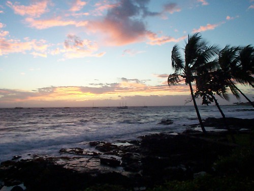
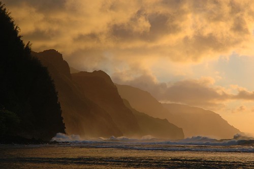
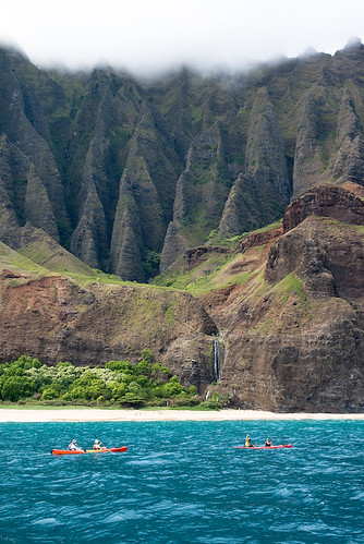
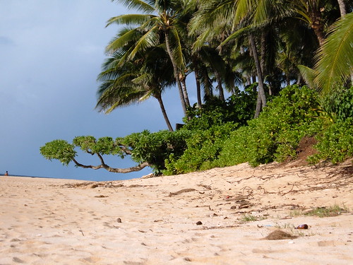
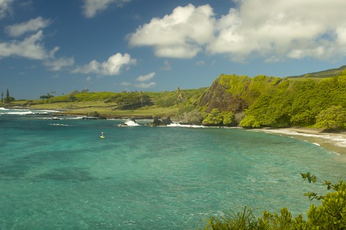
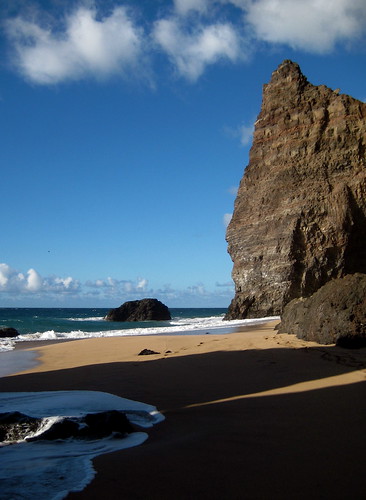
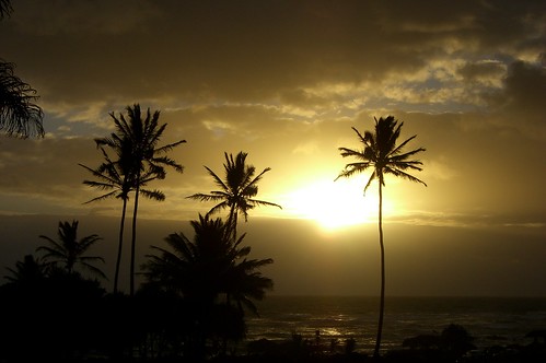
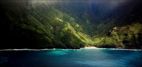


