Comments Off on Hawaiian Islands weather details & Aloha paragraphs / September 4-5, 2008
September 4-5 2008
Air Temperatures – The following maximum temperatures were recorded across the state of Hawaii Thursday afternoon:
Lihue, Kauai – 85 Honolulu, Oahu – 89 Kaneohe, Oahu – 85 Kahului, Maui – 88 Hilo, Hawaii – 85
Kailua-kona – 83 Air Temperaturesranged between these warmest and coolest spots near sea level, and on the taller mountains…at 4 p.m. Thursday afternoon:
Honolulu, Oahu– 87F Kailua-kona, Hawaii– 81
Haleakala Crater- 63 (near 10,000 feet on Maui)
Mauna Kea summit – 46 (near 14,000 feet on the Big Island) Precipitation Totals – The following numbers represent the largest precipitation totals (inches) during the last 24 hours on each of the major islands, as of Thursday afternoon:
0.22 Mount Waialeale, Kauai
0.35 Poamoho 2, Oahu
0.05 Molokai
0.00 Lanai
0.00 Kahoolawe 0.56 Kula Branch Station, Maui
0.26 Keahole airport, Big Island Weather Chart – Here’s the latest (automatically updated) weather mapshowing a 1030 millibar high pressure system located far to the northeast of Hawaii. At the same time we find several low pressure systems, with their associated cold front, pushing the high pressure cell’s ridge down closer to our islands. This pressure configuration will prompt our local trade winds to be lighter through Saturday. Satellite and Radar Images: To view the cloud conditions we have here in Hawaii, please use the following satellite links, starting off with theInfrared Satellite Image of the islands to see all the clouds around the state during the day and night. This next image is one that gives close images of the islands only during the daytime hours, and is referred to as a Close-up visible image. This next image shows a larger view of the Pacific…giving perspective to the wider ranging cloud patterns in the Pacific Ocean. To help you keep track of where any showers may be around the islands, here’s the latest animatedradar image.
Hawaii’s Mountains – Here’s a link to the live webcam on the summit of near 14,000 footMauna Kea on the Big Island of Hawaii. The tallest peak on the island of Maui is theHaleakala Crater, which is near 10,000 feet in elevation. These two webcams are available during the daylight hours here in the islands…and when there’s a big moon rising just after sunset for an hour or two! Plus, during the nights and early mornings you will be able to see stars, and the sunrise too…depending upon weather conditions.
Aloha Paragraphs
Large south swell breaking on our leeward beaches Photo Credit: flickr.com
The trade winds will continue blowing, although getting lighter today through Saturday…picking up Sunday into early next week.As this weather map shows, we have a 1031 millibar high pressure system far northeast of our islands Thursday night…well offshore from the northern California/southern Oregon coast. There are several low pressure systems to the north-northwest, with their associated cold fronts in the middle latitudes of the north central Pacific. These areas of low pressure will push this high pressure system’s ridge down closer to our islands over the next couple of days. This in turn has softened our local winds, giving a somewhat muggy feeling to our atmosphere near the beaches. By the way, the cold fronts won’t be able to push down into our tropical latitudes…remaining far to the northwest of our Hawaiian Islands. The computer models suggest that later this weekend, into early next week, our trade winds will boost back into the moderately strong levels again.
There will be a few generally light showers on the windward sides, with some afternoon clouds and showers leeward as well. The lighter trade winds through Saturday will prompt some increase in afternoon upcountry showers falling locally. The bias for showers will return to the windward sides later this weekend into next week, as the trade winds become better established then. The overlying atmosphere is quite dry and stable at the moment, so that we shouldn’t see heavy showers falling anywhere. There are still no organized rain makers in our vicinity, so that fair weather will prevail. As usual, and depending upon the amount of upstream cloudiness, there will be fairly minor variations in showers arriving along our windward coasts and slopes…generally though most generous during the night and early morning hours. In terms of tropical cyclones, all the action remains over in the Caribbean Sea, and the Atlantic Ocean.At last count we have three tropical storms: Josephine, Ike, and Hanna in the Atlantic and Caribbean…with a fourth trying to breaking into this already well established group. Here’s a graphical map, showing these storms that continue to march westward. The next in line to impact the United States, will be tropical storm Hanna, which will bring inclement weather conditions all along the eastern seaboard…here’s a tracking map. Then Ike, which has become a hurricane, will slam through the Caribbean Islands, potentially on its way towards an impact in the United States. Here’s what the hurricane models are showing for Ike, which looks like it will become a potentially very dangerous storm…putting eastern Florida potentially under the gun. Josephine is still too far away to know what she will eventually do.
It’s early Thursday evening here in Kihei, Maui, as I begin writing this last paragraph of today’s tropical weather narrative from Hawaii. These days its quite easy to get away with calling our local weather conditions normal. This hasn’t always been the case this year, although there hasn’t been anything all that unusual for the last month or more. We’ll continue to see just the fairly classic late summer trade wind weather pattern. The one thing though, that would qualify as headline weather news, is occurring in the marine sector, where high surf conditions prevail. This larger than normal south swell was generated late last week to the east of New Zealand, where a very dynamic storm generated swells in our direction. Not every leeward, south and west facing beach, will find these pounders breaking, but enough will, so that folks should pay close attention to not getting hurt out there in these waves! Other than that, I expect nice to very nice conditions to prevail, with perhaps more sunshine in general during the morning hours, than during the afternoons. I’ll be back very early Friday morning, well before sunrise as a matter of fact, preparing your next tropical weather narrative from paradise. I hope you have a great Thursday night until then! Aloha for now…Glenn.
Interesting: Nissan Motor Company on Thursday became the first domestic automaker to launch a diesel car in Japan in six years, blazing the trail for rivals looking to revive the fuel-saving engine to cut greenhouse gas emissions. The X-Trail 20GT sport utility vehicle, powered by an engine lead-developed by partner Renault SA, is also the world’s first "clean" diesel car to meet Japan’s new emissions standards to kick in from October 2009, said to be the strictest in the world. Diesel cars make up more than half of the European market, but a powerful smear campaign by Tokyo’s popular governor in the late 1990s deriding them as smelly, noisy and polluting has all but erased the fuel-efficient cars from Japanese roads. Nissan was the standout among major automakers in U.S. auto sales data released on Wednesday, surprising investors with a 13.6 percent increase in August sales. The diesel X-Trail, only available in manual transmission, costs just under 3 million yen ($27,710), carrying a price premium of about 400,000 yen ($3,695) over a comparable gasoline version. Nissan said it hoped to sell about 100 units a month.
"For a long time, we had no diesel cars in Japan," Nissan Chief Operating Officer Toshiyuki Shiga told a news conference. "I’m not sure how much it would spread in the market now, but if it does well we will consider broadening the line-up." The only other diesel car available in Japan now is Daimler AG’s Mercedes-Benz E320 CDI sedan, launched in late 2006. While the company says reception has exceeded its expectations, a sticker price of over 8 million yen ($73,510) has kept sales volumes here at a paltry 100 units a month. Volkswagen AG, Japan‘s top-selling foreign brand, is also preparing to offer a diesel car in Japan next year. Other domestic automakers, including Honda Motor Co, Mitsubishi Motors Corp and Subaru-maker Fuji Heavy Industries Ltd, will be joining Nissan in the segment over the next few years. But conspicuously absent from that list is market leader Toyota Motor Corp, without which proliferation may be difficult.
Air Temperatures – The following maximum temperatures were recorded across the state of Hawaii Wednesday afternoon:
Lihue, Kauai – 85 Honolulu, Oahu – 89 Kaneohe, Oahu – 84 Kahului, Maui – 86 Hilo, Hawaii – 86
Kailua-kona – 83 Air Temperaturesranged between these warmest and coolest spots near sea level, and on the taller mountains…at 4 p.m. Wednesday afternoon:
Port Allen, Kauai– 88F Kahului, Maui– 81
Haleakala Crater- 55 (near 10,000 feet on Maui)
Mauna Kea summit – 48 (near 14,000 feet on the Big Island) Precipitation Totals – The following numbers represent the largest precipitation totals (inches) during the last 24 hours on each of the major islands, as of Wednesday afternoon: 0.76 Mount Waialeale, Kauai
0.13 Oahu Forest NWR, Oahu
0.00 Molokai
0.00 Lanai
0.00 Kahoolawe 0.11 Oheo Gulch, Maui
0.08 Hilo airport, Big Island Weather Chart – Here’s the latest (automatically updated) weather mapshowing a 1032 millibar high pressure system located far to the northeast of Hawaii. At the same time we find a low pressure system, with its associated cold front, pushing the high pressure cell’s ridge down closer to our islands. This pressure configuration will prompt our local trade winds to be lighter for the time being. Satellite and Radar Images: To view the cloud conditions we have here in Hawaii, please use the following satellite links, starting off with theInfrared Satellite Image of the islands to see all the clouds around the state during the day and night. This next image is one that gives close images of the islands only during the daytime hours, and is referred to as a Close-up visible image. This next image shows a larger view of the Pacific…giving perspective to the wider ranging cloud patterns in the Pacific Ocean. To help you keep track of where any showers may be around the islands, here’s the latest animatedradar image.
Hawaii’s Mountains – Here’s a link to the live webcam on the summit of near 14,000 footMauna Kea on the Big Island of Hawaii. The tallest peak on the island of Maui is theHaleakala Crater, which is near 10,000 feet in elevation. These two webcams are available during the daylight hours here in the islands…and when there’s a big moon rising just after sunset for an hour or two! Plus, during the nights and early mornings you will be able to see stars, and the sunrise too…depending upon weather conditions.
The trade winds will prevail, getting softer over the next few days…only to rebound again during the weekend.As thisweather mapshows, we have a 1031 millibar high pressure system far northeast of our islands Wednesday evening…the source of our local winds. In general, lighter trade winds will prevail, with those typically windier places having somewhat higher gusts. As the trades get lighter into Friday, our atmosphere may begin to feel a bit sultry along the beaches…with the cooling and refreshing relief from the muggy weather on tap for the weekend and beyond.
There will be occasional showery periods along the windward sides, although nothing out of the ordinary. Satellite imagery shows clouds moving by to the north, in the trade wind flow…which may bring a spattering of showers overnight perhaps to Kauai. The lighter trade winds through Friday will prompt some increase in afternoon upcountry showers falling locally. The showers will re-focus their efforts along the windward sides again this weekend…as the trade winds pick up in strength.
In terms of tropical cyclones, all the action remains over in the Caribbean Sea, and the Atlantic Ocean.At last count we have three tropical storms: Josephine, Ike, and Hanna, along with now retired Gustav, which is still bringing heavy rains to the south. Here’s a graphical map, showing this impressive array of storms that continue to march westward. The next in line to impact the United States, will be hurricane Hanna, taking aim on the south Carolina coast or thereabouts…here’s a tracking map. Then Ike, which will become a hurricane very soon, will wander into the Caribbean Islands, although it’s still too early to know exactly where it will end up, or whether it will impact the United States. Here’s what the hurricane models are showing for Ike, which looks like it will become a potentially very dangerous storm.
It’s early Wednesday evening here in Kihei, Maui, as I begin writing this last paragraph of today’s tropical weather narrative from Hawaii. The area of showers being carried along in the trade wind flow, that we thought might bring an increase in showers tonight…now will slide by to the north. The southern edge of these showers may clip the northern half of Kauai, but not much further south than that. As the trade winds slow down now, there will be an increase in the amount of shower activity we see in the upcountry leeward sides, especially over Maui and the Big Island…like we saw on Maui Wednesday afternoon. Other than that, the big news will occur along our leeward beaches, where rising high surf will begin pounding those south and west facing shores. Folks visiting these shorelines over the next 3-4 days should exercise caution when going in the ocean, as the breakers will be large and potentially dangerous to inexperienced people. A high surf advisory has been issued by the NWS forecast office in Honolulu, beginning on Thursday. I’ll be back very early Thursday morning with your next new weather narrative, I hope you have a great Wednesday night until then. Aloha for now…Glenn.
Interesting:
A huge 19 square mile (55 square km) ice shelf in Canada’s northern Arctic broke away last month and the remaining shelves have shrunk at a "massive and disturbing" rate, the latest sign of accelerating climate change in the remote region, scientists said on Tuesday. They said the Markham Ice Shelf, one of just five remaining ice shelves in the Canadian Arctic, split away from Ellesmere Island in early August. They also said two large chunks totaling 47 square miles had broken off the nearby Serson Ice Shelf, reducing it in size by 60 percent. "The changes … were massive and disturbing," said Warwick Vincent, director of the Centre for Northern Studies at Laval University in Quebec. Temperatures in large parts of the Arctic have risen far faster than the global average in recent decades, a development that experts say is linked to global warming. "These substantial calving events underscore the rapidity of changes taking place in the Arctic," said Derek Mueller, an Arctic ice shelf specialist at TrentUniversity in Ontario.
"These changes are irreversible under the present climate and indicate that the environmental conditions that have kept these ice shelves in balance for thousands of years are no longer present," he said in an e-mailed statement from the research team sent late on Tuesday. Mueller said the total amount of ice lost from the shelves along Ellesmere Island this summer totaled 83 square miles — more than three times the area of Manhattan island. The figure is more than 10 times the amount of ice shelf cover that scientists estimated on July 30 would vanish from around the island this summer. "Reduced sea ice conditions and unusually high air temperatures have facilitated the ice shelf losses," said Luke Copland of the University of Ottawa.
Interesting2:
Energy can be saved in surprising places, but let’s meander a bit first. If you own a new car, built in the last decade or so, take look around the wheel wells or perhaps the door sills. You might see pieces of clear plastic film adhered to the bodywork. If you have them they’re put there by the manufacturer to protect the paint in that area from scuff marks or stone chips. The plastic film is a lot tougher than paint is. That plastic film might make you wonder. If a stone resistant film can be applied to a few small areas why not the same film to protect a whole car? And why only in clear plastic? Why not in colors? According Soliant, of Lancaster, South Carolina, the film could be applied to whole cars and in an infinite number of color options, including two-tones, metallics, pearlescents, special effects and finishes including chrome and brushed chrome. Soliant says it can match any color car makers throw at them.
Cars wouldn’t have to be painted, just a snazzy film applied, including graphics. Why don’t the big car companies do this? Stubbornness. Slow to change. Huge investments in assembly-line paint shops that they don’t want to scrap. But that’s just big car companies. Little ones, especially startups, might be more open minded and willing to “paintfilm” a car rather than paint it conventionally. (Paintfilm is the name Soliant gives its product.) As it turns out, one startup, Carbon Motors Corporation, which is developing and will manufacture the world’s first purpose-built law enforcement patrol vehicle, the E7 will give paintfilm a go. In building its production facility for the diesel engined, plastic and aluminum patrol car the company will skip building a paint shop, saving as much as 40 percent of the cost of the new production plant. And the savings won’t end there. Year after year there will be continued energy savings.
Interesting3:
Thesurvival chances of the albatross, now officially the most threatened seabird family in the world, have been improved following a new report released by WWF-South Africa. At least 28 species of albatross and petrel have been caught by South African fisheries, of which 13 are threatened with extinction. The birds are caught trying to retrieve bait from longline fishing hooks, or are injured or killed during trawling operations. A deterioration of their breeding habitats and targeted hunting operations are other factors. Samantha Petersen, manager of the WWF-South Africa Responsible Fisheries Programme, said that the report – “Understanding and Mitigating Vulnerable Bycatch in Southern African Trawl and Longline Fisheries” – improved substantially the understanding of the circumstances under which seabirds were killed.
“The findings help accurately identify management measures to reduce the wasteful killing of these magnificent birds while not unnecessarily disrupting fishing activities or impacting other vulnerable marine life like turtles and sharks,” said Dr Petersen. The report, which follows WWF’s release of the results of four years of groundbreaking longline marine turtle bycatch data in Latin America, reinforces the need for fishermen to implement the mandatory and readily available measures that help prevent birds from becoming entangled in fishing gear. “While this information is valuable, it’s crucial that it translates into compliance with mitigation measures on the part of fishing operations,” added Dr Petersen. The report says that bird-scaring lines have proved to be simple yet effective way of preventing seabirds from being snagged during longline fishing, and similar measures have helped limit the impact of other fishing techniques.
Interesting4:
The next U.S. president must show greater leadership than previous administrations in tackling climate change, according to the head of the United Nations. "All the countries in the international community are looking for more and greater leadership from the United States," U.N. Secretary-General Ban Ki-moon said after a celebration to mark the 20th anniversary of the founding of the Intergovernmental Panel on Climate Change. Ban praised the administration of U.S. President George W. Bush for playing an "important role" in discussing how countries can minimize greenhouse gas emissions, thought to be the main reason for global warming.
But the United States has not done enough to turn talk into action, considering it is one of the biggest emitters of greenhouse gases, he said. Emerging powers such as China and India point to the U.S. rejection of the 1997 Kyoto Protocol, when arguing against making commitments on climate change. Ban told journalists in Geneva that all developed countries need to take part if emissions are to be cut by at least half by 2050. In a report published last year, the IPCC said such a reduction would be necessary to stop global temperatures rising more than 3.6 degrees above preindustrial levels. Failure to do so will lead to severe droughts and cause massive hunger and poverty, it said. "I think that, whoever may be elected as the president of the United States, may be in a better position to lead this process," Ban said.
Interesting5:
Reports of unusually fiery orange sunsets on Earth and ruby red rings around the planet Venus have popped up on the Internet in the last week. Some skywatchers suspect that these views are being colored by the dust and gases injected into the atmosphere by the Aug. 7 eruption of Alaska‘s Kasatochi volcano. The skywatchers are probably right. Kasatochi, part of the Aleutian Island chain, sent an ash plume more than 35,000 feet (10,600 meters) into the atmosphere when it erupted last month. "This is a big ash-producing eruption," said Peter Cervelli, a research geophysicist with the United States Geological Survey at the Alaska Volcano Observatory. During a survey of the area after the eruption, Cervelli and his colleagues found ashfall deposits more than 6 inches (15 centimeters) deep at a spot 15.5 miles (25 kilometers) away from the volcano.
The fine ash injected by a volcanic eruption into the stratosphere can be carried by winds all over the world. Sulfur dioxide spewed from volcanoes can react in the atmosphere to form sulfate aerosols (aerosols are tiny particles suspended in the air). Both ash and aerosols can scatter the sun’s rays, giving a sunset its apparent color. Particles in the air normally scatter incoming sunlight — this is why the sky is blue. Sunsets (and sunrises) appear reddish because the sun’s rays have more of the atmosphere to travel through, and only the longer waves at the red end of the spectrum can make it. Sulfate aerosols in particular can intensify this effect by adding more obstacles for the light to get through.
Air Temperatures – The following maximum temperatures were recorded across the state of Hawaii Tuesday afternoon:
Lihue, Kauai – 85 Honolulu, Oahu – 88 Kaneohe, Oahu – 82 Kahului, Maui – 88 Hilo, Hawaii – 85
Kailua-kona – 86 Air Temperaturesranged between these warmest and coolest spots near sea level, and on the taller mountains…at 4 p.m. Tuesday afternoon:
Port Allen, Kauai– 88F Princeville, Kauai– 81
Haleakala Crater- 57 (near 10,000 feet on Maui)
Mauna Kea summit – 48 (near 14,000 feet on the Big Island) Precipitation Totals – The following numbers represent the largest precipitation totals (inches) during the last 24 hours on each of the major islands, as of Tuesday afternoon:
0.46 Mount Waialeale, Kauai 0.80 Oahu Forest NWR, Oahu
0.00 Molokai
0.00 Lanai
0.00 Kahoolawe 0.19 West Wailuaiki, Maui
0.47 Kealakekua, Big Island Weather Chart – Here’s the latest (automatically updated) weather mapshowing a 1031 millibar high pressure system located far to the northeast of Hawaii. This pressure configuration will keep our trade winds blowing generally in the light to moderately strong range…although stronger and gusty in those windiest locations. Satellite and Radar Images: To view the cloud conditions we have here in Hawaii, please use the following satellite links, starting off with theInfrared Satellite Image of the islands to see all the clouds around the state during the day and night. This next image is one that gives close images of the islands only during the daytime hours, and is referred to as a Close-up visible image. This next image shows a larger view of the Pacific…giving perspective to the wider ranging cloud patterns in the Pacific Ocean. To help you keep track of where any showers may be around the islands, here’s the latest animatedradar image.
Hawaii’s Mountains – Here’s a link to the live webcam on the summit of near 14,000 footMauna Kea on the Big Island of Hawaii. The tallest peak on the island of Maui is theHaleakala Crater, which is near 10,000 feet in elevation. These two webcams are available during the daylight hours here in the islands…and when there’s a big moon rising just after sunset for an hour or two! Plus, during the nights and early mornings you will be able to see stars, and the sunrise too…depending upon weather conditions.
Aloha Paragraphs
Maui in the distance, from Kohala on the Big Island Photo Credit: flickr.com
The long lasting trade wind weather pattern will continue through this week.As thisweather mapshows, we have a 1030 millibar high pressure system far northeast of our islands Tuesday evening…the source of our local winds. In general, light to moderately strong trade winds will prevail, with those typically windier places having higher gusts. The winds have calmed down enough now, or are about to…that the short-lived small craft wind advisory around Maui and the Big Island was dropped Tuesday afternoon.
The trade winds will carry a few showers to the windward sides at times. The upcountry leeward sides could see an afternoon shower as well. The upper level trough of low pressure, which provided some enhancement to our local showers over the last several days, has moved far enough away now…that there will be no more influence here in Hawaii. This leaves us in a fairly normal precipitation regime, with nothing out of the ordinary expected for the time being…with only a minor increase in showers Wednesday into the night, then drier again Thursday.
A tropical disturbance well south-southwest of the Hawaiian Islands remains non-threatening.This area, which is approximately 700 miles south-southwest of Honolulu, is moving in a westerly direction. The upper level winds aren’t favorable for strengthening…with little if any chance of it becoming a tropical depression. Here’s a satellite image of the area, look for the small thunderstorm complex directly south of our islands…showing quite a bit of upper wind shear on the thunderstorms associated with this area of disturbed weather. Here’s what the hurricane models are showing for what’s being called Investigation Area 95C.
In terms of tropical cyclones, all the action remains over in the Caribbean Sea, and the Atlantic Ocean.At last count we have three tropical storms: Josephine, Ike, and Hanna, along with soon to be retired Gustav, which is dissipating quickly, although still brining gusty winds and very heavy rains. Here’s a graphical track map, showing this impressive parade of storms that continue to march westward. The next in line to impact the United States, will be hurricane Hanna, taking aim on the south Carolina coast or thereabouts. I’ll continue to carry some news about these storms, but will back off a little from the detail that I brought to this page with former hurricane Gustav.
It’s early Tuesday evening here in Kihei, Maui, as I begin writing this last paragraph of today’s tropical weather narrative from Hawaii.Glancing out the window here in Kihei, I see a predominance of clear blue skies, with a spattering of white cumulus clouds around the edges. The trade winds continue to blow nicely, helping to temper the otherwise hot late summer afternoon temperatures. The strongest gust that I note at around 5pm this afternoon, was the rather impressive 39 mph, at that windy Maalaea Bay. Looking into the future, I still don’t see anything of any threat on the weather horizon. This leaves us with just the usual windward biased showers, which may become a bit more numerous during the next 24-36 hours. All things considered, our weather remains on the tame side, with just the right amount of wind and rain to keep the word "Paradise", properly fixed to our Aloha state! I’ll be back very early Wednesday morning with your next new tropical weather narrative, I hope you have a great Tuesday night until then! Aloha for now…Glenn.
The sun has reached a milestone not seen for nearly 100 years: an entire month has passed without a single visible sunspot being noted. The event is significant as many climatologists now believe solar magnetic activity – which determines the number of sunspots — is an influencing factor for climate on earth. According to data from Mount Wilson Observatory, UCLA, more than an entire month has passed without a spot. The last time such an event occurred was June of 1913. Sunspot data has been collected since 1749. When the sun is active, it’s not uncommon to see sunspot numbers of 100 or more in a single month. Every 11 years, activity slows, and numbers briefly drop to near-zero. Normally sunspots return very quickly, as a new cycle begins. But this year — which corresponds to the start of Solar Cycle 24 — has been extraordinarily long and quiet, with the first seven months averaging a sunspot number of only 3.
August followed with none at all. The astonishing rapid drop of the past year has defied predictions, and caught nearly all astronomers by surprise. In 2005, a pair of astronomers from the National Solar Observatory (NSO) in Tucson attempted to publish a paper in the journal Science. The pair looked at minute spectroscopic and magnetic changes in the sun. By extrapolating forward, they reached the startling result that, within 10 years, sunspots would vanish entirely. At the time, the sun was very active. Most of their peers laughed at what they considered an unsubstantiated conclusion. The journal ultimately rejected the paper as being too controversial. The paper’s lead author, William Livingston, tells DailyTech that, while the refusal may have been justified at the time, recent data fits his theory well. He says he will be "secretly pleased" if his predictions come to pass.
Interesting2:
As Anne Giblin was lugging four-foot tubes of Arctic lakebed mud from her inflatable raft to her nearby lab this summer, she said, “Mud is a great storyteller.”Dr. Giblin, a senior scientist at the Marine Biological Laboratory in Woods Hole, Mass., is part of the Long Term Ecological Research network at an Arctic science outpost here operated by the University of Alaska at Fairbanks. Public discussion of complicated climate change is largely reduced to carbon: carbon emissions, carbon footprints, carbon trading. But other chemicals have large roles in the planet’s health, and the one Dr. Giblin is looking for in Arctic mud, one that a growing number of other researchers are also concentrating on, is nitrogen. In addition to having a role in climate change, nitrogen has a huge, probably more important biological impact through its presence in fertilizer. Peter Vitousek, a Stanford ecologist whose 1994 essay put nitrogen on the environmental map, co-authored a study this summer in the journal Nature that put greater attention on the nitrogen cycle and warned against ignoring it in favor of carbon benefits.
For example, Dr. Vitousek said in an interview, “There’s a great danger in doing something like, oh, overfertilizing a cornfield to boost biofuel consumption, where the carbon benefits are far outweighed by the nitrogen damage.” Soon after Dr. Vitousek’s report, the journal Geophysical Research Letters branded as a “missing greenhouse gas” nitrogen trifluoride, which is used in production of semiconductors and in liquid-crystal displays found in many electronics. Nitrogen trifluoride, which is not one of the six gases covered by the Kyoto Protocol, the celebrated international global warming accord, is about 17,000 times more potent than carbon dioxide. Its estimated worldwide release into the atmosphere this year is equivalent to the total global-warming emissions from Austria. “The nitrogen dilemma,” Dr. Vitousek added, “is not just thinking that carbon is all that matters. But also thinking that global warming is the only environmental issue. The weakening of biodiversity, the pollution of rivers, these are local issues that need local attention. Smog. Acid rain. Coasts. Forests. It’s all nitrogen.”
Interesting3:
Researchers confirm that surface temperatures in the Northern Hemisphere were warmer over the last 10 years than any time during the last 1300 years, and, if the climate scientists include the somewhat controversial data derived from tree-ring records, the warming is anomalous for at least 1700 years. "Some have argued that tree-ring data is unacceptable for this type of study," says Michael Mann, associate professor of meteorology and geosciences and director of PennState‘s Earth System Science Center. "Now we can eliminate tree rings and still have enough data from other so-called ‘proxies’ to derive a long-term Northern Hemisphere temperature record." The proxies used by the researchers included information from marine and lake sediment cores, ice cores, coral cores and tree rings. "We looked at a much expanded database and our methods are more sophisticated than those used previously," says Mann.
In today’s (Sept. 2) online edition of the Proceedings of the National Academy of Sciences, the researchers note, "Conclusions are less definitive for the Southern Hemisphere and globe, which we attribute to larger uncertainties arising from the sparser available proxy data in the Southern Hemisphere." The research team included Mann; Ray Bradley, university distinguished professor, geosciences and director, Climate System Research Center, University of Massachusetts; Malcolm Hughes, regents’ professor, and Fenbiao Ni, research associate, the Laboratory of Tree Ring Research, University of Arizona; Zhihua Zhang and Sonya Miller, research associates, meteorology, Penn State; and Scott Rutherford, assistant professor, environmental sciences, Roger Williams University. The National Research Council suggested revisiting surface temperatures in their "Surface Temperature Reconstructions for the Last 2,000 Years," to include newer data and techniques and confirmed results of a 1990s paper by Mann and colleagues. Results of this study without tree-ring data show that for the Northern Hemisphere, the last 10 years are likely unusually warm for not just the past 1,000 as reported in the 1990s paper and others, but for at least another 300 years going back to about A.D. 700 without using tree-ring data. The same conclusion holds back to A.D. 300 if the researchers include tree-ring data.
Interesting4:
Could our coastlines disappear underwater much sooner than we think? The controversial view that sea levels could rise at a rate of more than 1 metre per century has found support from a new study of a long-melted ice sheet.In reconstructing the events at the end of the last ice age, Anders Carlson of the University of Wisconsin-Madison and colleagues found that the Laurentide ice sheet, which covered most of North America between 95,000 and 7000 years ago, rapidly disintegrated. The researchers began by studying beryllium isotopes in rocks to determine how the outer edges of the two final chunks of the Laurentide ice sheet retreated. They found that the ice retreated rapidly between 9000 and 8500 years ago, stabilised, and then made its final rapid retreat between 7600 and 6800 years ago. The team calculated the volume of water that would have been released in each of these melting stages, and the rate at which it must have raised sea levels. They concluded that levels would have climbed 1.3 metres per century in the earlier period, and 0.7 metres per century in the final melt.
Carlson then used a sophisticated computer model — one that is used to forecast future climate change — to check the results. The model predicted an average sea level rise of 1.3 metres per century. "The forces that led to the demise of the Laurentide ice sheet in a very rapid way are comparable to the forces the same computer models predict we will experience this century if we do not rapidly curb greenhouse gas emissions," says Gavin Schmidt of the NASA Goddard Institute for Space Studies, who collaborated with Carlson on the study. For Mark Siddall of the University of Bristol, UK, and Michael Kaplan of the Lamont Doherty Earth Observatory in New York, however, there remain many differences between what happened nearly 10,000 years ago and the climate change Earth is currently experiencing. "To what extent this dynamic response of the Laurentide ice sheet to past temperature change can be considered analogous to present and future reduction of the Greenland ice sheet remains unresolved," they say in an associated commentary. "But their work suggests that future reductions of the Greenland ice sheet on the order of one metre per century are not out of the question."
Air Temperatures – The following maximum temperatures were recorded across the state of Hawaii Monday afternoon:
Lihue, Kauai – 85 Honolulu, Oahu – 88 Kaneohe, Oahu – 83 Kahului, Maui – 87 Hilo, Hawaii – 83
Kailua-kona – 85 Air Temperaturesranged between these warmest and coolest spots near sea level, and on the taller mountains…at 6 p.m. Monday evening:
Port Allen, Kauai– 84F Molokai airport – 78
Haleakala Crater- 46 (near 10,000 feet on Maui)
Mauna Kea summit – 41 (near 14,000 feet on the Big Island) Precipitation Totals – The following numbers represent the largest precipitation totals (inches) during the last 24 hours on each of the major islands, as of Monday afternoon:
0.82 Wainiha, Kauai
0.44 South Fork Kaukonahua, Oahu
0.01 Molokai
0.00 Lanai
0.05 Kahoolawe 0.36 Puu kukui, Maui 0.97 Pahoa, Big Island Weather Chart – Here’s the latest (automatically updated) weather mapshowing a 1029 millibar high pressure system located far to the northeast of Hawaii. This pressure configuration will keep our trade winds blowing generally in the light to moderately strong range…although stronger and gusty in those windiest locations. Satellite and Radar Images: To view the cloud conditions we have here in Hawaii, please use the following satellite links, starting off with theInfrared Satellite Image of the islands to see all the clouds around the state during the day and night. This next image is one that gives close images of the islands only during the daytime hours, and is referred to as a Close-up visible image. This next image shows a larger view of the Pacific…giving perspective to the wider ranging cloud patterns in the Pacific Ocean. To help you keep track of where any showers may be around the islands, here’s the latest animatedradar image.
Hawaii’s Mountains – Here’s a link to the live webcam on the summit of near 14,000 footMauna Kea on the Big Island of Hawaii. The tallest peak on the island of Maui is theHaleakala Crater, which is near 10,000 feet in elevation. These two webcams are available during the daylight hours here in the islands…and when there’s a big moon rising just after sunset for an hour or two! Plus, during the nights and early mornings you will be able to see stars, and the sunrise too…depending upon weather conditions.
Aloha Paragraphs
Molokai in the distance…from pineapple fields on Maui Photo Credit: flickr.com
Light to moderately strong trade winds will remain well established over the Hawaiian Islands through the next week. As this weather map shows, we have a large 1029 millibar high pressure system far northeast of our islands now…the source of our local winds. In general, light to moderately strong trade winds will prevail…with those typically windier places having higher gusts. The winds have gotten strong enough in places around Maui and the Big Island, that small craft wind advisories have been hoisted Monday.
There will be showers at times along the windward sides through Tuesday…then drier weather will prevail by mid-week.There will be some enhancement to our windward biased showers at times, with an occasional heavy shower falling. This will be the result of cooler air aloft, associated with an upper trough of low pressure to the west of Kauai. The upcountry leeward sides could see an afternoon shower as well. Shower activity will begin to ease up some starting Wednesday. Hurricane Gustav came ashore over the Louisiana coast early Monday morning as a category 2 storm. As this track map from the National Hurricane Center in Miami shows…the gradually weakening hurricane has already degraded into a weaker tropical storm. The winds will diminish as it continues its journey over land, although rainfall will remain heavy. Gustave will weaken further Tuesday into a tropical depression. Here’s the latestsatellite image of the storm. Here is looping radar image of Gustav as it moves inland.
Meanwhile, hurricane Hanna, in the Caribbean Sea, will strengthen as it continues on towards the southeast coast of the United States. As this NHC tracking map shows, Hanna is expected to be a hurricane when it makes landfall somewhere along the South Carolina coast. Here’s what the hurricane models are showing to be the various tracks over the next several days. Here’s a satellite image of Hanna, which will take over soon as the focus in the world of hurricanes…as Gustav winds down overland and becomes a remnant low pressure system over Texas or Oklahoma by mid-week. Meanwhile, we see yet another tropical system called tropical depression 9, in the Atlantic. This tropical cyclone has recently become tropical storm Ike, and eventually hurricane Ike as it heads towards the Bahamas. Here’s a NHC tracking map of Ike.
Speaking of tropical systems, there’s an area of low pressure, what we could consider a tropical disturbance, to the south of Hawaii now. This area, which is approximately 700 miles south of Honolulu, is moving in a west-northwest direction. The upper level winds aren’t favorable for strengthening…with little if any chance of it becoming a tropical depression. Here’s a satellite image of the area, look for the small thunderstorm complex directly south of our islands. Here’s what the hurricane models are showing for what’s being called Investigation Area 95C.
It’s early Monday evening here in Kula, Maui, as I begin writing this last paragraph of today’s tropical weather narrative from Hawaii. What a great day Monday was, and it was particularly appreciated I think due to the fact it was the Labor Day holiday! I thoroughly enjoyed myself, visiting with friends, with the high point of the day spent up at the lavender farm in Waipoli…here in Kula. I loved the views from there, and it was very interesting seeing all the various varieties of lavender. Apparently there are some 200 different kinds of this wonderfully scented plant. The rest of the day I spent at home, working with my neighbors around the property. I had to drag myself indoors at sunset, as it was still so nice out there. I’m looking forward to getting back into my regular work routine starting early Tuesday morning, when I’ll meet you here again then. I hope you have a great Monday night until then! Aloha for now…Glenn.
Air Temperatures – The following maximum temperatures were recorded across the state of Hawaii Sunday afternoon:
Lihue, Kauai – 85 Honolulu, Oahu – 88 Kaneohe, Oahu – 83 Kahului, Maui – 88 Hilo, Hawaii – 84
Kailua-kona – 85 Air Temperaturesranged between these warmest and coolest spots near sea level, and on the taller mountains…at 3 p.m. Sunday afternoon:
Kapalua, Maui– 88F Kaheohe, Oahu – 81
Haleakala Crater- missing (near 10,000 feet on Maui)
Mauna Kea summit – missing (near 14,000 feet on the Big Island) Precipitation Totals – The following numbers represent the largest precipitation totals (inches) during the last 24 hours on each of the major islands, as of Sunday afternoon:
0.79 Mount Waialaele, Kauai
0.49 Manoa Valley, Oahu
0.01 Molokai
0.00 Lanai
0.13 Kahoolawe 1.30 Ulupalakua, Maui
1.16 Honaunau, Big Island Weather Chart – Here’s the latest (automatically updated) weather mapshowing a 1031 millibar high pressure system located far to the northeast of Hawaii. This pressure configuration will keep our trade winds blowing generally in the moderately strong range…although stronger and gusty in those windiest locations. Satellite and Radar Images: To view the cloud conditions we have here in Hawaii, please use the following satellite links, starting off with theInfrared Satellite Image of the islands to see all the clouds around the state during the day and night. This next image is one that gives close images of the islands only during the daytime hours, and is referred to as a Close-up visible image. This next image shows a larger view of the Pacific…giving perspective to the wider ranging cloud patterns in the Pacific Ocean. To help you keep track of where any showers may be around the islands, here’s the latest animatedradar image.
Hawaii’s Mountains – Here’s a link to the live webcam on the summit of near 14,000 footMauna Kea on the Big Island of Hawaii. The tallest peak on the island of Maui is theHaleakala Crater, which is near 10,000 feet in elevation. These two webcams are available during the daylight hours here in the islands…and when there’s a big moon rising just after sunset for an hour or two! Plus, during the nights and early mornings you will be able to see stars, and the sunrise too…depending upon weather conditions.
Aloha Paragraphs
Waipio Valley on the Big Island Photo Credit: flickr.com
Light to moderately strong trade winds will remain well established over the Hawaiian Islands through the next week. As this weather map shows, we have a large 1031 millibar high pressure system far northeast of our islands now…the source of our local winds. In general, light to moderately strong trade winds will prevail…with those typically windier places having higher gusts.
There will be showers at times along the windward sides, followed by less showery periods through Labor Day.The rainfall pattern continues to be one with occasional passing showers…and then returning to drier conditions. There will be some enhancement to our windward biased showers at times, with an occasional heavy shower falling. This will be the result of cooler air aloft, associated with an upper trough of low pressure. The upcountry leeward sides will see afternoon showers at times through the Labor Day holiday as well…some of which could be quite generous on Maui and the Big Island. Dangerous hurricane Gustav has shown some weakening (category 3) as it continues its journey through the Gulf coast. As this track map from the National Hurricane Center in Miami shows…it continues on a straight line towards the Louisiana coast, to the west of New Orleans. The northeast quadrant (upper right portion) of a forward moving hurricane is regarded as the most severe part of the storm. This most most damaging part of the storm remains a distinct threat to the New Orleans area. This hurricane will bring major hurricane force winds…along with extensive flooding and storm surge to the area. Evacuations continue Sunday afternoon, before Gustav makes landfall perhaps as early as Monday morning. Tropical storm force winds are close to reaching the coast Sunday evening. Here’s the latestsatellite image of the hurricane. Here is looping radar image of Gustav as it moves towards the coast.
Meanwhile, tropical storm Hanna, in the Caribbean Sea, will strengthen as it continues on towards the southeast coast of the United States. As this NHC tracking map shows, Hanna is expected to be a hurricane when it makes landfall somewhere between Georgia and South Carolina. Here’s what the hurricane models are showing to be the various tracks over the next several days. Here’s a satellite image of Hanna, which will be the lead headline weather news…after Gustav does his thing along the Gulf coast.
Speaking of tropical systems, there’s an area of low pressure, what we could consider a tropical disturbance, to the south of Hawaii now. This area, which is approximately 600 miles south of Honolulu, is moving in a west-northwest direction. The upper level winds aren’t especially favorable for strengthening, although this concentrated area of deep convection will need to be watched. Here’s a satellite image of the area, look for the small thunderstorm complex directly south of our islands. Here’s what the hurricane models are showing for what’s being called Investigation Area 95C.
It’s late Sunday afternoon here in Kula, Maui, as I begin writing this last paragraph of today’s tropical weather narrative from Hawaii.You know, weather forecasting during a weather pattern such as we now have going on here in the islands…is tough. One day the showers are here, and the next day they aren’t. These all important fluctuations don’t always coincide with, or match exactly what that day’s forecast calls for! It’s somewhat hit or miss, that is, the showers come and go, as do the accurate, and the inaccurate forecasts with them. I was expecting afternoon showers up here on the slopes of the Haleakala Crater Sunday, like yesterday, and sure enough, they are nowhere to be found. Oh well, it’s like life itself I suppose, one can only hope for the best, and take what they get. As I’m fond of saying, or at least thinking: the trick seems to be in the acceptance of what comes our way, using the old analogy…taking responsibility for what we have going on in our lives day by day, right down into the moment by moment reality. I hope you have a great Sunday night wherever you happen to be accepting the present! I’ll be back Monday morning, not as early as most Monday mornings though, as it is a national holiday. Aloha for now…Glenn.
Air Temperatures – The following maximum temperatures were recorded across the state of Hawaii Saturday afternoon:
Lihue, Kauai – 85 Honolulu, Oahu – 88 Kaneohe, Oahu – 83 Kahului, Maui – 88 Hilo, Hawaii – 86
Kailua-kona – 85 Air Temperaturesranged between these warmest and coolest spots near sea level, and on the taller mountains…at 4 p.m. Saturday afternoon:
Barking Sands, Kauai– 86F Princeville, Kauai – 82
Haleakala Crater- 50 (near 10,000 feet on Maui)
Mauna Kea summit – 43 (near 14,000 feet on the Big Island) Precipitation Totals – The following numbers represent the largest precipitation totals (inches) during the last 24 hours on each of the major islands, as of Saturday afternoon:
0.41 Waihina, Kauai 0.83 Manoa Valley, Oahu
0.04 Molokai
0.08 Lanai
0.12 Kahoolawe 0.70 Puu Kukui, Maui
0.50 Piihona, Big Island Weather Chart – Here’s the latest (automatically updated) weather mapshowing high pressure system located far to the north of Hawaii. This pressure configuration will keep our trade winds blowing generally in the moderately strong range…although stronger and gusty in those windiest locations. Satellite and Radar Images: To view the cloud conditions we have here in Hawaii, please use the following satellite links, starting off with theInfrared Satellite Image of the islands to see all the clouds around the state during the day and night. This next image is one that gives close images of the islands only during the daytime hours, and is referred to as a Close-up visible image. This next image shows a larger view of the Pacific…giving perspective to the wider ranging cloud patterns in the Pacific Ocean. To help you keep track of where any showers may be around the islands, here’s the latest animatedradar image.
Hawaii’s Mountains – Here’s a link to the live webcam on the summit of near 14,000 footMauna Kea on the Big Island of Hawaii. The tallest peak on the island of Maui is theHaleakala Crater, which is near 10,000 feet in elevation. These two webcams are available during the daylight hours here in the islands…and when there’s a big moon rising just after sunset for an hour or two! Plus, during the nights and early mornings you will be able to see stars, and the sunrise too…depending upon weather conditions.
Steady, moderately strong trade winds will remain well established over the Hawaiian Islands. As this weather map shows, we have a large 1032 millibar high pressure system far northeast of our islands this weekend…the source of our local winds. The winds remain just below the small craft wind advisory levels in those windier coastal and channel waters. In general, light to moderately strong trade winds will prevail…with those typically windier places having higher gusts.
There will be showers at times along the windward sides, punctuated by less showery periods through this long holiday weekend.The rainfall pattern continues to be one with occasional passing showers…and then returning to drier conditions. There will be some enhancement to our windward biased showers at times, with an occasional heavy shower falling. This will be the result of cooler air aloft, associated with an upper trough of low pressure. The upcountry leeward sides will see occasional showers at times through the Labor Day holiday weekend as well. Dangerous hurricane (category 4) Gustav has shown explosive strengthening, as it heads into the Gulf of Mexico. As this track map from the National Hurricane Center in Miami shows…at the moment, it’s heading towards the Louisiana coast, just slightly to the west of the New Orleans metropolitan area. The northeast quadrant (upper right portion) of a forward moving hurricane is regarded as the most severe part of the storm. This most most damaging part of the storm remains a distinct threat to the New Orleans area. This very dangerous hurricane will cause an extremely windy event…along with extensive flooding the area. Evacuations have begun along those coasts now, and will continue in earnest over the several days, before making landfall at some point Monday. Here’s the latest satellite image of Gustav. Here is looping radar image of Gustav as it heads over Cuba into the Gulf of Mexico.
It’s early Saturday evening here in Kula, Maui, as I begin writing this last paragraph of today’s tropical weather narrative from Hawaii. I woke up last night to the unusual sound of rain falling here in Kula, which was part of those off and on showers that we’re expecting over the next several days. The clouds gathered on the slopes of the Haleakala Crater early in the day Saturday, which lead to a brief period of showers. Radar has shown briefly heavy showers over near Keokea and Ulupalakua this afternoon, where 1.00" per hour rainfall rates have occurred. At the moment, its quite sunny over my area, although I can see quite a few clouds congregating on the horizon in most directions. I anticipate that these off and on showers will continue here and there, although most outdoor activities will remain available during the days…especially down towards the leeward beaches. I’ll be back early Sunday morning with your next new weather narrative, and with more information on dangerous major hurricane Gustav, as it steams its way towards the Gulf coast. I hope you have a great Saturday night wherever you happen to be spending it! Aloha for now…Glenn.
Interesting:
The Indonesian government is to double the size of a national park that is one of the last havens for endangered Sumatran elephants and tigers. TessoNiloNational Park was created in 2004 with 38,000 hectares of forest. Today’s declaration will see that figure increase to 86,000 by the end of this year. "This is an important milestone toward securing a future for the Sumatran elephant and tiger," said Dr. Mubariq Ahmad, WWF-Indonesia’s Chief Executive. “To ensure the commitment is effectively implemented we must redouble our efforts to eliminate poaching and illegal settlements within this special forest.” With more than 4,000 plant species recorded so far, the forest of Tesso Nilo has the highest lowland forest plant biodiversity known to science, with many species yet to be discovered.
WWF has been supporting the government effort to extend and protect the park as the last block of lowland forest in central Sumatra large enough to support a viable elephant population. About 60 to 80 elephants are estimated to live there, along with 50 tigers. Tesso Nilo forest is also an important watershed for more than 40,000 people living in the surrounding 22 villages. “Tesso Nilo is still under serious threat from illegal activities, but if we can protect the forests there it will give some of Sumatra’s most endangered wildlife the breathing room they need to survive,” Dr Ahmad said. “And while we greatly appreciate this precedent for more protection from the Indonesian government, there are other areas on Sumatra that need safeguarding for the sake of its wildlife, its threatened indigenous peoples and to reduce the climate impacts of clearing.”
Interesting2:
A solution to the world’s worst case of ongoing mass poisoning, linked to rising cancer rates in Southern Asia, has been developed by researchers from Queen’s University Belfast. It is estimated that over 70 million people in Eastern India and Bangladesh, experience involuntary arsenic exposure from consuming water and rice; the main staple food in the region. This includes farmers who have to use contaminated groundwater from minor irrigation schemes. It is estimated that for every random sample of 100 people in the Bengal Delta, at least one person will be near death as a result of arsenic poisoning, while five in 100 will be experiencing other symptoms.
Now, researchers have created new low-cost technology to provide arsenic-free water to millions of people in South Asia currently exposed to high levels of the poison in groundwater. Leading an international team, Queen’s researchers have developed a trial plant in Kasimpore, near Calcutta, which offers chemical-free groundwater treatment technology to rural communities for all their drinking and farming needs. The technology is based on recharging a part of the groundwater, after aeration, into a subterranean aquifer (permeable rock) able to hold water. Increased levels of oxygen in the groundwater slow down the arsenic release from the soil. At higher dissolved oxygen levels, soil micro organisms, as well as iron and manganese, reduce the dissolved arsenic level significantly.
Interesting3:
New research strongly suggests that a mix of preventative agents, such as those found in concentrated black raspberries, may more effectively inhibit cancer development than single agents aimed at shutting down a particular gene. Researchers at the Ohio State University Comprehensive Cancer Center examined the effect of freeze-dried black raspberries on genes altered by a chemical carcinogen in an animal model of esophageal cancer. The carcinogen affected the activity of some 2,200 genes in the animals’ esophagus in only one week, but 460 of those genes were restored to normal activity in animals that consumed freeze-dried black raspberry powder as part of their diet during the exposure. These findings, published in recent issue of the journal Cancer Research, also helped identify 53 genes that may play a fundamental role in early cancer development and may therefore be important targets for chemoprevention agents.
“We have clearly shown that berries, which contain a variety of anticancer compounds, have a genome-wide effect on the expression of genes involved in cancer development,” says principal investigator Gary D. Stoner, a professor of pathology, human nutrition and medicine who studies dietary agents for the prevention of esophageal cancer. “This suggests to us that a mixture of preventative agents, which berries provide, may more effectively prevent cancer than a single agent that targets only one or a few genes.” Stoner notes that black raspberries have vitamins, minerals, phenols and phytosterols, many of which individually are known to prevent cancer in animals.
Air Temperatures – The following maximum temperatures were recorded across the state of Hawaii Friday afternoon:
Lihue, Kauai – 84 Honolulu, Oahu – 89 Kaneohe, Oahu – 85 Kahului, Maui – 88 Hilo, Hawaii – 86
Kailua-kona – 84 Air Temperaturesranged between these warmest and coolest spots near sea level, and on the taller mountains…at 4 p.m. Friday afternoon:
Port Allen, Kauai– 88F Kaneohe, Oahu – 82
Haleakala Crater- 50 (near 10,000 feet on Maui)
Mauna Kea summit – 39 (near 14,000 feet on the Big Island) Precipitation Totals – The following numbers represent the largest precipitation totals (inches) during the last 24 hours on each of the major islands, as of Friday afternoon:
0.40 Mount Waialeale, Kauai 0.50 Poamoho 2, Oahu
0.03 Molokai
0.00 Lanai
0.00 Kahoolawe 0.31 Puu Kukui, Maui
0.45 Pahala, Big Island Weather Chart – Here’s the latest (automatically updated) weather mapshowing high pressure system located far to the north of Hawaii. This pressure configuration will keep our trade winds blowing generally in the moderately strong range…although stronger and gusty in those windiest locations. Satellite and Radar Images: To view the cloud conditions we have here in Hawaii, please use the following satellite links, starting off with theInfrared Satellite Image of the islands to see all the clouds around the state during the day and night. This next image is one that gives close images of the islands only during the daytime hours, and is referred to as a Close-up visible image. This next image shows a larger view of the Pacific…giving perspective to the wider ranging cloud patterns in the Pacific Ocean. To help you keep track of where any showers may be around the islands, here’s the latest animatedradar image.
Hawaii’s Mountains – Here’s a link to the live webcam on the summit of near 14,000 footMauna Kea on the Big Island of Hawaii. The tallest peak on the island of Maui is theHaleakala Crater, which is near 10,000 feet in elevation. These two webcams are available during the daylight hours here in the islands…and when there’s a big moon rising just after sunset for an hour or two! Plus, during the nights and early mornings you will be able to see stars, and the sunrise too…depending upon weather conditions.
Aloha Paragraphs
Bodyboarding the north shore of Oahu Photo Credit: flickr.com
A fairly dynamic high pressure center to our north, will keep brisk trades blowing across our area well into the future. These typical late summer winds will remain fixed on our Hawaiian Islands, with no end in sight through at least the next week. The winds aren’t quite strong enough to trigger a small craft wind advisory at the moment, but they are close in those windiest areas around Maui and the Big Island. The daytime hours will have the strongest winds, easing off some during the nights as usual. In general, light to moderately strong trade winds will prevail…with those typically windier places having somewhat higher gusts.
There will be periodic bouts of showers along the windward sides, punctuated by less showery times over the next several days.The rainfall pattern continues to be one with occasional passing showers…and then returning to drier conditions. There may be some enhancement (locally heavy) to our windward biased showers at times, as cooler air aloft, associated with troughs of low pressure, edge in our direction. The upcountry leeward sides may see an afternoon shower at times through the Labor Day holiday weekend as well. Strengthening hurricane Gustav continues to take aim on the vulnerable Gulf of Mexico coast. This soon to be major hurricane will do some shifting around in its path over the very warm waters of the Gulf, so that there remains some uncertainty about exactly where it will strike. As this track map from the National Hurricane Center in Miami shows…at the moment, it’s heading towards the Louisiana coast, just slightly to the west of the New Orleans metropolitan area. The northeast quadrant (upper right portion) of a forward moving hurricane harbors the most severe weather conditions. This most violent part of the storm remains a distinct threat to the New Orleans area. As mentioned in the paragraphs above, the trade winds will continue to blow, carrying areas of showery clouds towards the windward north and east facing parts of the state at times. The most likely occurrences for these moisture laden clouds to arrive, would be Friday evening into the night, and then again around Labor Day. The predictability of these incoming showers is difficult, especially the further out into the future one tries to nail down these showery increases in moisture. Probably the best way to think about it, or plan on it, would be knowing that there will be periods of windward showers at times, which as anyone living on the windward side knows…can happen pretty much anytime the trade winds are blowing! As this satellite image shows, there are those cloud elements upstream, in relation to the trade winds, which will bring their showers with them in an off and on manner.
It’s early Friday evening here in Kihei, Maui, as I begin writing this last paragraph of today’s tropical weather narrative from Hawaii. I’m about ready to head out for the three day long, Labor Day holiday weekend. It’s always a great feeling to have all that free time to fill with anything that catches my fancy. The beginning of this weekend will begin as I take in the new action/adventure film called Traitor (2008), starring Don Cheadle and Guy Pearce among others. This film is being described as a taut international thriller, set against a jigsaw puzzle of covert counter-espionage operations. One critic described it as "a smarter movie about terrorism." Another person says this, "promising premise devolves into a by-the-numbers espionage thriller." It seems to be getting generally a B grade, which seems good enough to get this Maui weatherman in the theater for the opening night. I’m a bit put off by the violent nature of this film, and am hesistant to provide a trailer, so please be forewarned that the trailer, and the film itself, are definitely not for the faint of heart! I’ll be back early Saturday morning with your next new weather narrative, I hope you have a great Friday night until then! Aloha for now…Glenn.
Interesting1:
The Indonesian government is to double the size of a national park that is one of the last havens for endangered Sumatran elephants and tigers. TessoNiloNational Park was created in 2004 with 38,000 hectares of forest. Today’s declaration will see that figure increase to 86,000 by the end of this year. "This is an important milestone toward securing a future for the Sumatran elephant and tiger," said Dr. Mubariq Ahmad, WWF-Indonesia’s Chief Executive. “To ensure the commitment is effectively implemented we must redouble our efforts to eliminate poaching and illegal settlements within this special forest.” With more than 4,000 plant species recorded so far, the forest of Tesso Nilo has the highest lowland forest plant biodiversity known to science, with many species yet to be discovered.
WWF has been supporting the government effort to extend and protect the park as the last block of lowland forest in central Sumatra large enough to support a viable elephant population. About 60 to 80 elephants are estimated to live there, along with 50 tigers. Tesso Nilo forest is also an important watershed for more than 40,000 people living in the surrounding 22 villages. “Tesso Nilo is still under serious threat from illegal activities, but if we can protect the forests there it will give some of Sumatra’s most endangered wildlife the breathing room they need to survive,” Dr Ahmad said. “And while we greatly appreciate this precedent for more protection from the Indonesian government, there are other areas on Sumatra that need safeguarding for the sake of its wildlife, its threatened indigenous peoples and to reduce the climate impacts of clearing.”
Interesting2:
A solution to the world’s worst case of ongoing mass poisoning, linked to rising cancer rates in Southern Asia, has been developed by researchers from Queen’s University Belfast. It is estimated that over 70 million people in Eastern India and Bangladesh, experience involuntary arsenic exposure from consuming water and rice; the main staple food in the region. This includes farmers who have to use contaminated groundwater from minor irrigation schemes. It is estimated that for every random sample of 100 people in the Bengal Delta, at least one person will be near death as a result of arsenic poisoning, while five in 100 will be experiencing other symptoms.
Now, researchers have created new low-cost technology to provide arsenic-free water to millions of people in South Asia currently exposed to high levels of the poison in groundwater. Leading an international team, Queen’s researchers have developed a trial plant in Kasimpore, near Calcutta, which offers chemical-free groundwater treatment technology to rural communities for all their drinking and farming needs. The technology is based on recharging a part of the groundwater, after aeration, into a subterranean aquifer (permeable rock) able to hold water. Increased levels of oxygen in the groundwater slow down the arsenic release from the soil. At higher dissolved oxygen levels, soil micro organisms, as well as iron and manganese, reduce the dissolved arsenic level significantly.
Interesting3:
New research strongly suggests that a mix of preventative agents, such as those found in concentrated black raspberries, may more effectively inhibit cancer development than single agents aimed at shutting down a particular gene. Researchers at the Ohio State University Comprehensive Cancer Center examined the effect of freeze-dried black raspberries on genes altered by a chemical carcinogen in an animal model of esophageal cancer. The carcinogen affected the activity of some 2,200 genes in the animals’ esophagus in only one week, but 460 of those genes were restored to normal activity in animals that consumed freeze-dried black raspberry powder as part of their diet during the exposure. These findings, published in recent issue of the journal Cancer Research, also helped identify 53 genes that may play a fundamental role in early cancer development and may therefore be important targets for chemoprevention agents.
“We have clearly shown that berries, which contain a variety of anticancer compounds, have a genome-wide effect on the expression of genes involved in cancer development,” says principal investigator Gary D. Stoner, a professor of pathology, human nutrition and medicine who studies dietary agents for the prevention of esophageal cancer. “This suggests to us that a mixture of preventative agents, which berries provide, may more effectively prevent cancer than a single agent that targets only one or a few genes.” Stoner notes that black raspberries have vitamins, minerals, phenols and phytosterols, many of which individually are known to prevent cancer in animals.
Air Temperatures – The following maximum temperatures were recorded across the state of Hawaii Thursday afternoon:
Lihue, Kauai – 86 Honolulu, Oahu – 88 Kaneohe, Oahu – 82 Kahului, Maui – 88 Hilo, Hawaii – 83
Kailua-kona – 84 Air Temperaturesranged between these warmest and coolest spots near sea level, and on the taller mountains…at 4 p.m. Thursday afternoon:
Barking Sands, Kauai– 86F Hilo, Hawaii – 80
Haleakala Crater- 52 (near 10,000 feet on Maui)
Mauna Kea summit – 41 (near 14,000 feet on the Big Island) Precipitation Totals – The following numbers represent the largest precipitation totals (inches) during the last 24 hours on each of the major islands, as of Thursday afternoon: 0.06 Mount Waialeale, Kauai
0.58 Oahu Forest NWR, Oahu
0.01 Molokai
0.00 Lanai
0.05 Kahoolawe 1.10 Ulupalakua, Maui 1.18 Piihonua, Big Island Weather Chart – Here’s the latest (automatically updated) weather mapshowing high pressure systems located far to the north, and northeast of Hawaii. This pressure configuration will keep our trade winds blowing generally in the moderately strong range…although stronger and gusty in those windiest locations. Satellite and Radar Images: To view the cloud conditions we have here in Hawaii, please use the following satellite links, starting off with theInfrared Satellite Image of the islands to see all the clouds around the state during the day and night. This next image is one that gives close images of the islands only during the daytime hours, and is referred to as a Close-up visible image. This next image shows a larger view of the Pacific…giving perspective to the wider ranging cloud patterns in the Pacific Ocean. To help you keep track of where any showers may be around the islands, here’s the latest animatedradar image.
Hawaii’s Mountains – Here’s a link to the live webcam on the summit of near 14,000 footMauna Kea on the Big Island of Hawaii. The tallest peak on the island of Maui is theHaleakala Crater, which is near 10,000 feet in elevation. These two webcams are available during the daylight hours here in the islands…and when there’s a big moon rising just after sunset for an hour or two! Plus, during the nights and early mornings you will be able to see stars, and the sunrise too…depending upon weather conditions.
Aloha Paragraphs
The lush tropical green of Hawaii Photo Credit: flickr.com
Broadly speaking, our local trade winds will continue to be moderately strong…with day to day variations in strength through the next week. These cooling and refreshing winds will shift between light to moderate, to fully moderately strong depending upon the day. As is common, the north and east facing windward areas will see the strongest winds. In contrast, the south and west facing leeward sections will be more protected from the easterly trade wind flow. At those times when the trade winds slip a bit, our atmosphere will begin to feel slightly muggy during the days.
There will be a mix of showers falling, sometimes along the windward coasts and slopes, and along the leeward slopes during the afternoons as well.The rainfall pattern continues to be one with occasional passing showers…and then returning to clear skies with no rain. As an upper level trough moves close through the rest of this week, we may see some enhancement to our local showers at times. There aren’t any cold fronts coming our way from the northwest, nor slugs of tropical moisture taking aim on our islands from the east or southeast.
Tropical storm Gustav is a storm that the computer hurricane models bring into the Gulf of Mexico as a strong category 3 hurricane. This hurricane will do some shifting around in its path over the very warm waters of the Gulf. As this track map from the National Hurricane Center in Miami shows…at the moment, it’s heading towards the Louisiana coast, just to the west of New Orleans. Everyone living along the Gulf coast, and in those areas further inland too, should be paying close attention to this dangerous tropical cyclone as it will be strengthening going forward.
It’s early Thursday evening here in Kihei, Maui, as I begin writing this last paragraph of today’s tropical weather narrative from Hawaii. As we move into Thursday night, we find almost completely clear skies in most parts of the state of Hawaii, which a few scattered clouds around the edges. The winds remained quite strong today, and even later in the afternoon, the winds were still gusting to 37 mph at that windy bay in Maalaea, here on Maui. As this satellite image shows, there are more clouds just to the east of our islands, what we call upstream in relation to the trade winds, which will carry the next batch of windward biased showers to us tonight into early Friday morning…especially from Maui up through Oahu, and to a lesser degree to Kauai and the Big island. Otherwise, looking well into the future, we find more of the generally fine weather conditions, which are expected to carry forth through the entirety of the upcoming Labor Day holiday weekend. I’ll be back very early Friday morning with your next new weather narrative from paradise, I hope you have a great Thursday night wherever you happen to be spending it! Aloha for now…Glenn.
Interesting:
A strong earthquake struck off Canada‘s west coast early Thursday near Vancouver Island. There were no immediate reports of major damage or injuries. The epicenter of the magnitude-6.1 quake was 97 miles west of Port Hardy and 293 miles west northwest of Vancouver, the U.S. Geological Survey said. It struck at a depth of about 6 miles. Geological Survey of Canada scientist Garry Rogers said there were no reports of injuries or damages and said it occurred too far off land for there to be any. He said it’s normal activity for the region and there’s nothing to be alarmed about. The quake was the latest in a series of coastal tremors since Monday.
Two quakes rattled the area Wednesday, both with magnitudes of around 5. There have been 18 quakes with a magnitude greater than four in the region this week. Seismologists said the tremors are occurring in a "seismically active" region, and they are too far offshore to be felt on land and too small to generate a tsunami. "Rarely a day goes by where we don’t have an earthquake. Once a year we have a swarm in the high fours, maybe a five. Once a decade we have a six," Rogers said. "It’s one of the most busiest earthquake areas in the world." Rogers said new ocean crust is forming in the area and that’s why it’s so active geologically.
Interesting2:
The Indonesian government is to double the size of a national park that is one of the last havens for endangered Sumatran elephants and tigers. TessoNiloNational Park was created in 2004 with 38,000 hectares of forest. Today’s declaration will see that figure increase to 86,000 by the end of this year. "This is an important milestone toward securing a future for the Sumatran elephant and tiger," said Dr. Mubariq Ahmad, WWF-Indonesia’s Chief Executive. “To ensure the commitment is effectively implemented we must redouble our efforts to eliminate poaching and illegal settlements within this special forest.” With more than 4,000 plant species recorded so far, the forest of Tesso Nilo has the highest lowland forest plant biodiversity known to science, with many species yet to be discovered.
WWF has been supporting the government effort to extend and protect the park as the last block of lowland forest in central Sumatra large enough to support a viable elephant population. About 60 to 80 elephants are estimated to live there, along with 50 tigers. Tesso Nilo forest is also an important watershed for more than 40,000 people living in the surrounding 22 villages. “Tesso Nilo is still under serious threat from illegal activities, but if we can protect the forests there it will give some of Sumatra’s most endangered wildlife the breathing room they need to survive,” Dr Ahmad said. “And while we greatly appreciate this precedent for more protection from the Indonesian government, there are other areas on Sumatra that need safeguarding for the sake of its wildlife, its threatened indigenous peoples and to reduce the climate impacts of clearing.”
Interesting3:
It seems to happen with depressing frequency – sunny skies turn to rain just as the weekend arrives. Now Spanish researchers say they have evidence that in some parts of Europe the weather really does follow a weekly cycle, although not in the straightforward way that the anecdote might suggest. Evidence has been mounting over the years that the weather in certain parts of the world, including the US, Japan and China, can be driven by the weekly cycle of human activity. This is because we tend to produce more air pollution during the week and less at the weekend. Evidence that such an effect occurs in Europe is controversial and has been harder to come by. Arturo Sanchez-Lorenzo of the University of Barcelona, Spain, and his colleagues examined data gathered between 1961 and 2004 from weather stations across Spain to see whether such a pattern existed. They claim to have found it in Spain, as well as hints of weekly changes in air circulation more broadly over western Europe.
Interesting4:
Giant clams two feet long might have helped feed prehistoric humans as they first migrated out of Africa, new research reveals. The species, Tridacna costata, once accounted for more than 80 percent of giant clams in the Red Sea, researcher now say. Today, these mollusks, the first new living species of giant clam found in two decades, represent less than 1 percent of giant clams living there. This novel clam, whose shell has a distinctive scalloped edge, was discovered while scientists were attempting to develop a breeding program for another giant clam species, Tridacna maxima, which is prized in the aquarium trade. The new species appears to live only in the shallowest waters, which makes it particularly vulnerable to overfishing.
"These are all strong indications that T. costata may be the earliest example of marine overexploitation," said researcher Claudio Richter, a marine ecologist at the Alfred-Wegener-Institute for Polar and Marine Research in Bremerhaven, Germany. Fossil evidence that the researchers uncovered suggests the stocks of these giant clams began crashing some 125,000 years ago, during the last interval between glacial periods. During that time, scientists think modern humans first emerged out of Africa, Richter said. These mollusks could have played a key role in feeding people during that crucial era, serving as a prime target due to their large size, the scientists added. Indeed, competition for these clams and other valuable sea resources "may have been an important driver for human expansion.
Air Temperatures – The following maximum temperatures were recorded across the state of Hawaii Wednesday afternoon:
Lihue, Kauai – 87 Honolulu, Oahu – 88 Kaneohe, Oahu – 83 Kahului, Maui – 86 Hilo, Hawaii – 87
Kailua-kona – 86 Air Temperaturesranged between these warmest and coolest spots near sea level, and on the taller mountains…at 4 p.m. Wednesday afternoon:
Port Allen, Kauai– 88F Kaneohe, Oahu – 80
Haleakala Crater- 54 (near 10,000 feet on Maui)
Mauna Kea summit – 41 (near 14,000 feet on the Big Island) Precipitation Totals – The following numbers represent the largest precipitation totals (inches) during the last 24 hours on each of the major islands, as of Wednesday afternoon:
1.21 Mount Waialeale, Kauai
0.48 Oahu Forest NWR, Oahu
0.06 Molokai
0.00 Lanai
0.00 Kahoolawe 0.25 West Wailuaiki, Maui
0.14 Kahua Ranch, Big Island Weather Chart – Here’s the latest (automatically updated) weather mapshowing a 1027 millibar high pressure system located to the northeast of Hawaii…with an associated ridge extending west to the north of our islands. This pressure configuration will keep our trade winds blowing generally in the light to moderately strong range through Friday. Satellite and Radar Images: To view the cloud conditions we have here in Hawaii, please use the following satellite links, starting off with theInfrared Satellite Image of the islands to see all the clouds around the state during the day and night. This next image is one that gives close images of the islands only during the daytime hours, and is referred to as a Close-up visible image. This next image shows a larger view of the Pacific…giving perspective to the wider ranging cloud patterns in the Pacific Ocean. To help you keep track of where any showers may be around the islands, here’s the latest animatedradar image.
Hawaii’s Mountains – Here’s a link to the live webcam on the summit of near 14,000 footMauna Kea on the Big Island of Hawaii. The tallest peak on the island of Maui is theHaleakala Crater, which is near 10,000 feet in elevation. These two webcams are available during the daylight hours here in the islands…and when there’s a big moon rising just after sunset for an hour or two! Plus, during the nights and early mornings you will be able to see stars, and the sunrise too…depending upon weather conditions.
The trade winds will continue blowing across the tropical latitudes of the north central Pacific, although gradually becoming lighter. This long lasting spell of moderately strong trade winds here in the islands, will finally begin to ease up a bit, as they shift from the current moderately strong realms, down into the light to moderately strong range by the weekend. The computer models suggest that as we move into next week, they will rebound again, bringing back their cooling relief from what may become rather sultry conditions around the weekend time frame.
The atmosphere has been quite stable lately, although a trough of pressure may make our air mass a bit more shower prone for the next several days.The precipitation pattern this past week has been one with occasional passing showers along the windward sides…and then returning to clear skies with no rain. As an upper level trough moves close through the rest of the week, we may see more generous showers at times. The leeward sides have been quite dry in general, although as the winds get lighter soon, that we may see an increase in upcountry afternoon showers developing. As the trade winds ramp-up again early next week, the bias for showers will return to the windward sides.
Tropical storm Gustav is a storm that the computer hurricane models bring into the Gulf of Mexico as a strong category 3 hurricane. This hurricane will likely do some shifting around in its path over the very warm waters of the Gulf, although as this track map from the National Hurricane Center in Miami shows…at the moment it’s heading directly towards the New Orleans area! This tropical cyclone will become big news, and I’m sure we will be hearing lots more about it, much of it won’t make for a pretty picture I’m afraid. Fortunately, the Hawaiian Islands, here in the north central Pacific remains free of any tropical storm activity!
It’s early Wednesday evening here in Kihei, Maui, as I begin writing this last paragraph of today’s tropical weather narrative from Hawaii. You know, each day is so different here in the islands, especially in terms of the day to day changes in weather. Today turned out to be more cloudy than normal in many areas, certainly that was the case here on Maui. There was yet another brush fire that broke out in south Maui, up above Kihei Wednesday afternoon. This is the 4th wild brush fire in the last five days! The brush and dead grass this summer is tender and dry, and fires can start so easily. I know that at least one of these fires was caused by people, and more than likely more than that. We need to all be very careful, as sooner or later, one of these blazes will get way out of hand, and people are going to be hurt, along with dwellings going up in smoke as well. I’ll be back very early Thursday morning with your next new weather narrative, I hope you have a great Wednesday night until then! Aloha for now…Glenn.
Interesting:
More ominous signs Wednesday have scientists saying that a global warming "tipping point" in the Arctic is happening before their eyes: Sea ice in the Arctic Ocean has melted to its second lowest level since satellite observations began. The National Snow and IceDataCenter in Boulder, Colo., reported that the extent of sea ice in the Arctic is down to 2.03 million square miles. The lowest point since 1979 is 1.65 million square miles set last September. With about three weeks left in the Arctic summer, this year could wind up breaking the previous record, scientists said. Arctic ice always melts in summer and refreezes in winter. But over the years, more of the ice is lost to the sea and with less of it recovered in winter. While ice reflects the sun’s heat, the open ocean absorbs more heat and the melting accelerates warming in other parts of the world. Sea ice also serves as primary habitat for threatened polar bears. "We could very well be in that quick slide downward in terms of passing a tipping point," said center senior scientist Mark Serreze.
"It’s tipping now. We’re seeing it happen now." Within a few years — "five to less than 10 years" — the Arctic could be free of sea ice in the summer, said NASA ice scientist Jay Zwally. "It also means that climate warming is also coming larger and faster than the models are predicting and nobody’s really taken into account that change yet," he said. Other scientists, including James Hansen, director of NASA’s Goddard Institute of Space Studies in New York, agreed. Hansen in a Wednesday e-mail said the sea ice "is the best current example of a tipping point." Last year was an unusual year when wind currents and other weather conditions coincided with global warming to worsen sea ice melt, Serreze said. Scientists wondered if last year’s melt was an unusual event or the start of a new and disturbing trend. This year’s results suggest the latter because the ice had recovered a bit more than usual thanks to a somewhat cooler winter, Serreze said. Then this month, when the melting rate usually slows, it sped up, he said.
Interesting2:
Scientists have cautioned that a warming planet could melt Greenland‘s vast ice sheet, a potentially catastrophic event that would raise sea levels and inundate coastal communities around the globe. Yet while they puzzle over when and whether this might happen, they’re also mystified over how the giant island formed so much ice in the first place. Greenland’s ice sheet is the second largest in the world, behind only Antarctica. Strangely, other parts of the globe at similar latitudes, including northern Canada and Siberia, don’t have year-round patches of ice anywhere near as extensive or thick. A new study finds that a mysterious drop in greenhouse gases around 3 million years ago allowed Greenland‘s ice to proliferate. The research could help with forecasts about the fate of the ice and the potential for rising seas.
If all of Greenland‘s ice were to melt, perhaps as quickly as in a few centuries, seas would rise 21 feet (6.5 meters) all around the planet, according to the U.S. Geological Survey. And already, an alarming melt is under way there, other studies find. In 2007, the ice melted at a rate of 150 percent of the average going back to 1988. Recent studies have found that as the ice melts more rapidly, water pours through fissures and gets under glaciers, acting like a lubricant to allow the ice to race ever-faster toward the sea. In addition, when snow melts at high altitudes and then refreezes, it can absorb up to four times more sunlight, creating even more melting the next year.
Interesting3:
Tokeep coral reefs from being eaten away by increasingly acidic oceans, humans need to limit the amount of climate-warming greenhouse gases in the atmosphere, a panel of marine scientists said on Wednesday. "The most logical and critical action to address the impacts of ocean acidification on coral reefs is to stabilize atmospheric carbon dioxide concentration," the scientists said in a document called the Honolulu Declaration, for release at a U.S. conference on coral reefs in Hawaii. Ocean acidification is another threat to corals caused by global warming, along with rising sea levels, higher sea surface temperatures and coral bleaching, the scientists said. Coral reefs are a "sentinel ecosystem," a sign that the environment is changing, said one of the experts, Billy Causey of the U.S. National Marine Sanctuary Program.
"Although ocean acidification is affecting the health of our oceans, the same thing — increased carbon dioxide in the atmosphere — is going to in fact be affecting terrestrial environments also," Causey said by telephone from Hawaii. Coral reefs offer economic and environmental benefits to millions of people, including coastal protection from waves and storms and as sources of food, pharmaceuticals, jobs and revenue, the declaration said. But corals are increasingly threatened by warming sea surface temperatures as well as ocean acidification. Oceans are getting more acidic because they have been absorbing some 525 billion tons of the greenhouse gas carbon dioxide over the last two centuries, about one-third of all human-generated carbon dioxide for that period.
Interesting4:
We’ve all been stunned by images showing the dramatic retreat of mountain glaciers. Yet few of us have given much thought to what happens next. Now the first study to look at how life invades soil immediately after mountain glaciers melt has an answer. Primitive bacteria step in to colonize the area, enrich the soil with nutrients, and even cement the ground, preventing landslides, say researchers who have studied the process in the Peruvian Andes. A few studies have looked at the types of plants that colonize mountain valleys that were previously covered in ice. But before plants move in there is usually a period, which at high latitudes and altitudes can last several years, during which the newly uncovered soil appears totally barren.
To investigate what is happening during this period, Steve Schmidt of the University of Colorado and colleagues examined the soil at the retreating edge of the Puca glacier in the Peruvian Andes. Between 2000 and 2005, they sampled the top 10 centimeters of ground that was revealed as the glacier moved uphill at a rate of 20 metres per year. They analyzed the chemical structure of the samples and screened for bacteria. They found that over the years, the "oldest" soil“ the dirt taken from the point that was revealed at the glacier edge in 2000“ changed rapidly. The first organisms to appear in the soil were cyanobacteria. These primitive bacteria are found in many marine ecosystems and some land-based ecosystems. It is these bacteria we have to thank for pumping oxygen into Earth’s atmosphere 3.4 billion years ago, allowing land life to evolve.
Interesting5:
Apilot program that began last year in Vermont in Brattleboro and BellowsFalls to allows consumers to use food stamps at farmers’ markets is now spreading across the state, and the rest of the country. In 2007, the experimental service was set up at the two WindhamCounty markets. While there were a few glitches with the wireless technology, six other markets are also trying the service out this season across the state. And at other markets from Maine to Hawaii, farmers are introducing the electronic debit systems that allow low income families to use their federal food assistance dollars to purchase local fruits and vegetables. The number of farmers’ markets across the country accepting electronic benefit transfer, or EBT, transactions increased from 532 in 2007 to 605 as of June 2008, according to the U.S. Department of Agriculture. USDA Undersecretary for Food, Nutrition and Consumer Services Nancy Montanez Johner, said both food stamp recipients and farmers have benefited from the success of the program. "Farmers’ markets give food stamp recipients opportunities to improve their nutrition by increasing their consumption of fresh fruit and vegetables," Montanez Johner said. "The Food Stamp Program also benefits local farmers by bringing additional customers to their markets to purchase their products."
Interesting 6:
A turtle that toddled alongside the dinosaurs died just days before laying a clutch of eggs. Now, about 75 million years later, paleontologists are announcing their find of the fossilized mother-to-be and the eggs tucked inside her body. Scientists from the Royal Tyrrell Museum of Palaeontology in Canada discovered the turtle in 1999 in a mud-filled channel in the badlands of southeastern Alberta. Then, in 2005, University of Calgary scientists found a nest of 26 eggs laid by another female of the same species in the same region. Both specimens, described this week in the journal Biology Letters, belong to an extinct turtle in the Adocus genus, a large river turtle that resembles today’s slider and cooter turtles. The pregnant turtle represents the first fossil turtle to be unearthed with eggs still inside the body cavity, the scientists say. "Although it is relatively rare to find the eggs and babies of extinct animals, it is even rarer to find them inside the body of the mother," said researcher Darla Zelenitsky, a geoscientist at the University of Calgary in Alberta, who was also involved in the first discovery of a dinosaur with eggs inside its body.
Interesting7:
The Zephyr solar plane has sailed to what may be a record for sun-powered unmanned flight. The 66-pound craft was aloft for 83 hours and 7 minutes. The plane makes use of ultra-lightweight carbon-fiber to save on weight. It flies on solar power generated by paper-thin silicon solar arrays on its wings. The Zephyr solar-powered plane is able to fly autonomously, using GPS to keep on track. Launched by hand, Zephyr charges its batteries during the day for night flying. Initially, the plane was flown remotely to an altitude of 60,000 feet; the plane was able to fly by itself for the remaining time. [The flight is unlikely to be an official record, however, because the company did not meet criteria laid down by the world’s air sports federation.] Other solar-powered surveillance planes are under development, like the Helios craft that has already flown a number of successful test flights. The Zephyr is considered a possible predecessor to the planned DARPA Vulture Five Year Flying Wing. The "five years" part refers to the length of proposed continuous flight time.
Air Temperatures – The following maximum temperatures were recorded across the state of Hawaii Tuesday afternoon:
Lihue, Kauai – 87 Honolulu, Oahu – 89 Kaneohe, Oahu – 84 Kahului, Maui – 87 Hilo, Hawaii – 86
Kailua-kona – 86 Air Temperaturesranged between these warmest and coolest spots near sea level, and on the taller mountains…at 4 p.m. Tuesday afternoon:
Port Allen, Kauai– 88F Molokai airport – 77
Haleakala Crater- 52 (near 10,000 feet on Maui)
Mauna Kea summit – 43 (near 14,000 feet on the Big Island) Precipitation Totals – The following numbers represent the largest precipitation totals (inches) during the last 24 hours on each of the major islands, as of Tuesday afternoon:
0.05 Mount Waialeale, Kauai
0.45 Manoa Valley, Oahu
0.03 Molokai
0.01 Lanai
0.19 Kahoolawe 1.05 Puu Kukui, Maui
0.31 Hilo airport, Big Island Weather Chart – Here’s the latest (automatically updated) weather mapshowing high pressure systems located to the north through northeast of Hawaii…with an associated ridge extending west to the north of our islands. This pressure configuration will keep our trade winds blowing generally in the light to moderately strong range, locally stronger in those windiest areas. Satellite and Radar Images: To view the cloud conditions we have here in Hawaii, please use the following satellite links, starting off with theInfrared Satellite Image of the islands to see all the clouds around the state during the day and night. This next image is one that gives close images of the islands only during the daytime hours, and is referred to as a Close-up visible image. This next image shows a larger view of the Pacific…giving perspective to the wider ranging cloud patterns in the Pacific Ocean. To help you keep track of where any showers may be around the islands, here’s the latest animatedradar image.
Hawaii’s Mountains – Here’s a link to the live webcam on the summit of near 14,000 footMauna Kea on the Big Island of Hawaii. The tallest peak on the island of Maui is theHaleakala Crater, which is near 10,000 feet in elevation. These two webcams are available during the daylight hours here in the islands…and when there’s a big moon rising just after sunset for an hour or two! Plus, during the nights and early mornings you will be able to see stars, and the sunrise too…depending upon weather conditions.
Trade winds will continue to grace our Hawaiian Islands well into the future. Thisweather map,shows high pressure systems located to the north through northeast of Hawaii. This pressure configuration will keep moderately strong winds blowing, locally stronger and gusty. The trades have eased enough now that the NWS forecast office in Honolulu has cancelled the small craft wind advisory active over for the windiest spots around Maui County, down through the Big Island.
Showers will be carried our way on the brisk trade winds, favoring the windward sides of the islands.The leeward sides will remain mostly sunny to partly cloudy during the days, with some localized cloudy periods…and an isolated shower here and there during afternoon hours. The overall weather pattern will remain favorably inclined for the time being, with no organized areas of showers taking aim on the islands into the foreseeable future. Conditions are dry enough now, so that we need to be very careful about brush fires.
It’s that time of year when we can see tropical cyclones here in the central Pacific, although there are none at the moment, thank goodness. Glancing over into the western Pacific though, we have a storm (14W) about ready to move across the northern part of Luzon Island in the Philippines. Looking in the other direction, over towards Mexico, we have dissipating tropical depression Julio bringing rain to northwest Mexico, into the southwest United States. The Caribbean Sea is very active with hurricane Gustav…which looks like it will cause big trouble along some coastline in the Gulf of Mexico this coming weekend!
It’s early Tuesday evening here in Kihei, Maui, as I begin writing this last paragraph of today’s tropical weather narrative from Hawaii. Tuesday started off a bit wetter than expected, at least here on Maui, where morning showers got wetter than they were "suppose to." Those showers headed up to Oahu during the day, where showers fell in places too…and may progress up the chain to Kauai tonight. As this batch of showers moved off, the islands of Maui become sunnier, and ended the day in a dry way. The trade winds are still with us, and will be through the rest of this week, and likely through much of the rest of the summer season into September. Looking out the window here in Kihei, I see mostly sunny skies out there, which should set the stage for a nice sunset, leading into another great sunrise on Wednesday! I hope you enjoy your Tuesday night, and that you will meet me here again Wednesday, when I’ll have your next new weather narrative from paradise waiting for you! Aloha for now…Glenn.
Interesting:
An investigation by the Associated Press (AP) has revealed that the drinking water of at least 41 million people in the United States is contaminated with pharmaceutical drugs. It has long been known that drugs are not wholly absorbed or broken down by the human body. Significant amounts of any medication taken eventually pass out of the body, primarily through the urine. "People think that if they take a medication, their body absorbs it and it disappears, but of course that’s not the case," EPA scientist Christian Daughton said. While sewage is treated before being released back into the environment, and water from reservoirs or rivers is also treated before being funneled back into the drinking water supply, these treatments are not able to remove all traces of medications.
And so far, the EPA has not regulated the presence of pharmaceuticals in drinking water, meaning that there are no laws in existence today that protect consumers from this increasingly dangerous chemical contaminant of the water supply. Medications for animals also contaminating the water supply Drugs given to animals are also entering the water supply. One study found that 10 percent of the steroids given to cattle pass directly through their bodies, while another study found that steroid concentrations in the water downstream of a Nebraska feedlot were four times as high as the water upstream. Male fish downstream of the feedlot were found to have depressed levels of testosterone and smaller than normal heads, most likely due to the pharmaceutical contamination in their water.
Interesting2:
The probability is growing that the global economy—not just the United States—will experience a serious recession. Recent developments suggest that all G7 economies are already in recession or close to tipping into one. Other advanced economies or emerging markets (the rest of the euro zone; New Zealand, Iceland, Estonia, Latvia, and some Southeast European economies) are also nearing a recessionary hard landing. When they reach it, there will be a sharp slowdown in the BRICs (Brazil, Russia, India, and China) and other emerging markets. This looming global recession is being fed by several factors: the collapse of housing bubbles in the United States, United Kingdom, Spain, Ireland, and other euro-zone members; punctured credit bubbles where money and credit was too easy for too long; the severe credit and liquidity crunch following the U.S. mortgage crisis; the negative wealth and investment effects of falling stock markets (already down by more than 20 percent globally); the global effects via trade links of the recession in the United States (which still counts for about 30 percent of global GDP); the U.S. dollar’s weakness, which reduces American trading partners’ competitiveness; and the stagflationary effects of high oil and commodity prices, which are forcing central banks to increase interest rates to fight inflation at a time when there are severe downside risks to growth and financial stability. Official data suggest that the U.S. economy entered into a recession in the first quarter of this year. The economy rebounded—in a double-dip, W-shaped recession—in the second quarter, boosted by the temporary effects on consumption of $100 billion in tax rebates. But those effects will fade by late summer.
Interesting3: Alternative fishing technology has been shown to save turtles while not affecting fish catches, according to a report released by WWF and the Inter-American Tropical Tuna Commission (IATTC). The report demonstrates how changing from the classic J hook to circular hooks, providing adequate training and tools to release turtles accidentally hooked and enhancing sustainable fishing practices, can dramatically reduce incidental catch (bycatch) of marine turtles without impacting fishing activity. “The results keep demonstrating that changing to circular hooks is the right choice, since it favours turtle conservation without having an impact on the economy of artisanal fisheries," said Moises Mug, Coordinator of the WWF Bycatch Initiative for the Eastern Pacific. "Together with fishermen we are building a culture for sustainable fishing practices that will guarantee fish stocks in the long term.”
The report – Bycatch Initiative: Eastern Pacific Program, A Vehicle Towards Sustainable Fisheries – is a comprehensive analysis of data collected during four years of work in eight different countries in the Eastern Pacific – Mexico, Panama, Costa Rica, El Salvador, Guatemala, Colombia, Ecuador and Peru. “Our goal is to reduce the incidental catch of marine turtles from the long-line fishing operations without affecting the fisheries activity which is a main source of food and income for local communities,” explained Martin Hall, Principal Researcher for the IATTC. Data gathered showed an overall significant trend of bycatch reduction, with a reduction of up to 89 per cent in the marine turtle bycatch per thousand hooks. Ninety-five per cent of all turtles caught in long-line fishing were recovered alive, while circle hooks performed as well as J hooks in the catch rates of tuna, billfishes and sharks fishery.
Interesting4: The race to go green has taken to the high seas with two Japanese companies saying they would begin work on the world’s first ship to have propulsion engines partially powered by solar energy. Japan’s biggest shipping line Nippon Yusen KK and Nippon Oil Corp said solar panels capable of generating 40 kilowatts of electricity would be placed on top of a 60,000 tonne car carrier to be used by Toyota Motor Corp. The solar panels would help conserve up to 6.5 percent of fuel oil used in powering diesel engines that generate electricity at any given moment. Solar panels for an average home usually generate 3.5 kilowatts of electricity.
The system is expected to help reduce carbon dioxide emissions by 1-2 percent, or about 20 tonnes per year, said Hideyuki Dohi, general manager at Nippon Oil’s energy system development department. Nippon Yusen will invest about 150 million yen ($1.4 million) in the solar panel system to be designed by Nippon Oil. Solar panels capable of generating several kilowatts of electricity have been used on large vessels before but their use has been limited to power for the crew’s living quarters. Damage to the panels from salt and vibration remain hurdles to be overcome. The ship is scheduled to be completed in December.
Interesting 5: Traces of a chemical once used by power plants leave birds looking fit, but singing another tune altogether. Wild chickadees exposed to permitted levels of polychlorinated biphenyls (PCBs) can’t keep a tune as well as other birds. Because females go for males with the best songs, PCB-exposed birds might lose out on mates, says Sara DeLeon, an ecologist at CornellUniversity in Ithaca, New York, who presented her research at a recent conference at the university. "The birds are living, not dying, but [PCBs] are affecting some part of their life cycle," she says. Researchers have long known that some chemicals, such DDT, can throw off a bird’s song, but none have determined whether exposure to trace amounts in the wild can influence songs and mating.
Interesting6:
The Zephyr solar plane has sailed to what may be a record for sun-powered unmanned flight. The 66-pound craft was aloft for 83 hours and 7 minutes. The plane makes use of ultra-lightweight carbon-fiber to save on weight. It flies on solar power generated by paper-thin silicon solar arrays on its wings. The Zephyr solar-powered plane is able to fly autonomously, using GPS to keep on track. Launched by hand, Zephyr charges its batteries during the day for night flying. Initially, the plane was flown remotely to an altitude of 60,000 feet; the plane was able to fly by itself for the remaining time. [The flight is unlikely to be an official record, however, because the company did not meet criteria laid down by the world’s air sports federation.] Other solar-powered surveillance planes are under development, like the Helios craft that has already flown a number of successful test flights. The Zephyr is considered a possible predecessor to the planned DARPA Vulture Five Year Flying Wing. The "five years" part refers to the length of proposed continuous flight time.


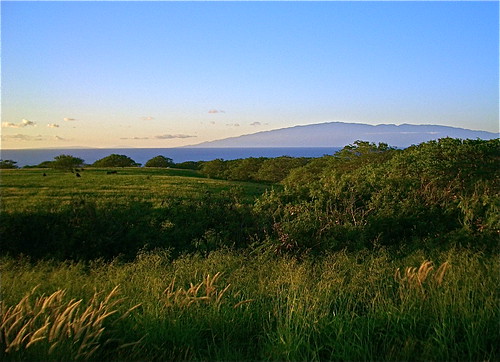
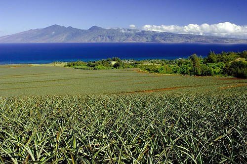


