


December 26-27 2008
Air Temperatures – The following maximum temperatures were recorded across the state of Hawaii Friday afternoon:
Lihue, Kauai – 77
Honolulu, Oahu – 82
Kaneohe, Oahu – 77
Kahului, Maui – 76
Hilo, Hawaii – 70
Kailua-kona – 80
Air Temperatures ranged between these warmest and coolest spots near sea level, and on the highest mountains…at 4 p.m. Friday afternoon:
Barking Sands, Kauai – 81F
Hilo, Hawaii – 68F
Haleakala Crater – 37 (near 10,000 feet on Maui)
Mauna Kea summit – 27 (near 14,000 feet on the Big Island)
Precipitation Totals – The following numbers represent the largest precipitation totals (inches) during the last 24 hours on each of the major islands, as of Friday afternoon:
1.64 Mohihi Crossing, Kauai
1.25 Waiawa, Oahu
0.38 Molokai
0.02 Lanai
0.26 Kahoolawe
7.73 Kaupo Gap, Maui
11.90 Waiakea Uka, Big Island
Weather Chart – Here’s the latest (automatically updated) weather map showing a strong 1034 millibar high pressure system to far to the northeast of the Hawaiian Islands. This trade wind producing high pressure system will cause locally gusty trade winds, although a bit lighter this weekend.
Satellite and Radar Images: To view the cloud conditions we have here in Hawaii, please use the following satellite links, starting off with the Infrared Satellite Image of the islands to see all the clouds around the state during the day and night. This next image is one that gives close images of the islands only during the daytime hours, and is referred to as a Close-up visible image. This next image shows a larger view of the Pacific…giving perspective to the wider ranging cloud patterns in the
Aloha Paragraphs
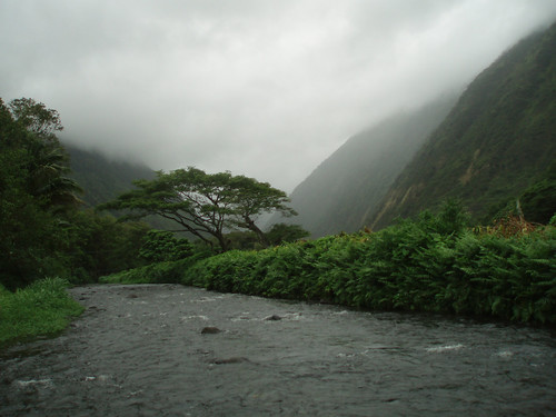
Rainy weather in Hawaii
Photo Credit: flickr.com
The trade winds are moving right along, and will continue right on into the weekend. A 1034 millibar high pressure system, is located to the northeast of Hawaii Friday night. This is keeping our local wind speeds rather gusty, with a small craft wind advisory active across most coastal waters from Oahu to the Big Island. A winter weather advisory remains in force over the two tall summits on the Big Island, where snow has been falling. The gusty trade winds will give way to somewhat lighter winds this weekend into early next week. A high surf advisory for the east facing shores of all the islands remains active as well, due to the fresh trade wind born wind swell along the windward sides.
An upper level low pressure system, combining with moisture bearing trade winds…are keeping the islands wet. The moisture riding in on these trade winds is keeping our windward sides soggy. At the upper altitudes, we have an upper level low pressure system, which has moved over the eastern side of the Hawaiian Islands. This low is enhancing the incoming showers, which will spread over into some leeward areas at times. We will find localized heavy showers occurring from the Big Island to Maui and beyond. These generally windward biased showers will stretch-up to Oahu and Kauai going into the weekend. The low pressure system will move away starting Monday, with improving weather conditions. A new low will form to the northwest around Wednesday…which will likely be too far away to influence our local weather then.
It’s early Friday evening here in Kihei, Maui, as I start writing this last paragraph. It was a rainy day here in the islands, although the bulk of it fell along the windward sides of the islands. At the time of this writing, the NWS issued flash flood warning remained in effect over the windward side of the Big Island. The other islands have seen showers too, with pretty much totally cloudy skies blocking our famous Hawaiian sunshine. Here’s a looping radar image, so you can keep track of where all those showers (some of which will be locally heavy) are falling…and there’s no lack of water falling from the sky now! As we head into the weekend, there will be more windward biased showers, some of which may stretch over to the leeward sides at times too. Meanwhile, up on the summits on the Big Island, snow has been falling. The webcam lens is covered with snow, and it will be getting dark soon, but here’s a link to that camera in case it shows the snow Saturday morning. ~~~ I’m about ready to head over to the Kahului side, to take in a new film. This film is called Valkyrie (2008), starring John Cruise and Kenneth Branagh, among many others. The film is based on actual events, a plot to assassinate Hilter is unfurled during the height of WWII. Here’s a trailer in case you are interested in seeing what I’ll be taking in this evening. ~~~ I’ll be back early Saturday morning with my response to this film, and of course with your next new weather narrative from the moisture laden Hawaiian Islands. I hope you have a great Friday night until then! Aloha for now…Glenn.
Interesting: An ancient underground water basin the size of Libya holds the key to Australia avoiding a water crisis as climate change bites the drought-hit nation. Australia’s Great Artesian Basin is one of the largest artesian groundwater basins in the world, covering 656,370 sq miles and lying beneath one-fifth of Australia. The basin holds 65 million giga-liters of water, about 820 times the amount of surface water in Australia, and enough to cover the Earth’s land mass under half a meter of water, says the Great Artesian Basin Coordinating Committee. And it is slowly topped up with 1 million mega-liters a year as rain filters through porous sandstone rock, becoming trapped in the underground basin. "There is probably enough water in there to last Australia’s needs for 1,500 years, if we wanted to use it all," says John Hillier, a hydro-geologist who has just completed the Great Artesian Basin Resource Study. But he and other experts warn that access to the basin’s water supply is under threat from declining artesian pressure, which forces the water to the surface via bores and springs.
If artesian pressure falls too far, due to excessive extraction of water, the ancient water source will be unreachable, except through costly pumping. Lying as much as 1.2 miles below ground, some parts of the basin are 1.8 miles from top to bottom. The basin was formed between 100 and 250 million years ago and consists of alternating layers of water bearing sandstone aquifers and non-water bearing siltstones and mudstones. Basin water is extracted through bores and is the only source of water for mining, tourism and grazing in Queensland, New South Wales and South Australia states, and the Northern Territory. The underground water spawns $2.4 billion worth of production a year from farming, mining and tourism, says the Great Artesian Basin Coordinating Committee.
Interesting2: A plan to build the United States’ first offshore wind farm took another step, after the Massachusetts Department of Environmental Protection approved its proposed undersea cables to transmit power to the mainland. The Cape Wind project, which would place 130 turbines about 4.7 miles off upscale Cape Cod, would provide "greater public benefit than detriment," the state review found. The proposed wind farm, opposed by beachfront homeowners who complain the 247-foot towers would spoil their views, would provide enough power for about 400,000 homes. Developers of the $1 billion project are still waiting on a composite state and local permit, as well as federal approvals by the U.S. Coast Guard, Department of the Interior and the Federal Aviation Administration, said Mark Rogers, a spokesman for privately held Cape Wind Associates LLC. Rogers said Cape Wind expects the permitting process to be complete by March.
Interesting3: Climate change, whaling, wild weather and water were the environmental issues dominating headlines this year. Australia mourned the loss of a conservation giant, University of Canberra freshwater ecologist and self-described political ”shit stirrer” Peter Cullen, who died in March. His funeral service was attended by more than 900 people, who came to Canberra from all over Australia to pay their respects to a courageous, outspoken champion of national water reform. In its annual summary of world weather trends, the World Meteorological Organization described 2008 as a year ”marked by weather extremes”. Australia had its share of wild weather, including record heat waves in Adelaide, worsening drought across the Murray-Darling Basin and violent storms unleashing floods across northern NSW and Queensland.
The year began with torrential rains causing the worst floods in 20 years across south-east Queensland and the NSW North Coast. More than 3000 people were stranded in NSW, with flood damage exceeding $250 million. Climate scientists, including Brisbane-based Professor Ian Lowe, have warned that Queensland can expect an increase in severe storms as global temperatures warm. This year, the Sunshine State bore the brunt of weather extremes, with 70 per cent of the state declared a disaster area due to storms, high winds and floods by the end of February. Premier Anna Bligh’s state Government subsequently announced a review of Queensland’s climate change strategy.
Interesting4: After weeks of waiting, mountain residents awoke to their first glimpse of winter on Dec. 13th, a few fluffy inches of powder that clung to the tops of boulders like chefs’ hats. More fell over the past two weeks, enough to bury the camel-colored meadow grass and wine-red willows in a deepening blanket of white. The magic, though, came late, just days before Christmas — one of the tardiest winter debuts ever. How much more snow will fall is anyone’s guess. A winter storm just hit Thursday, dumping several feet of snow, to the relief of snow-starved resorts.
But in the late arrival of this year’s snow season — and increasingly early spring snowmelt from the mountains — scientists and state officials are finding more than the signature of a natural drought. They believe they detect the fingerprint of climate change. The implications could be enormous. After all, the snowcapped Sierra is more than a skier’s paradise. It is a giant water faucet in the sky, a 400-mile-long, 60-mile-wide reservoir held in cold storage that supplies California with more than 60 percent of its water, much of it when it’s needed most: over the hot, dry summer months.
Interesting5: Wildlife satellite studies could lead to a radical re-thinking about how the snowy owl fits into the Northern ecosystem. "Six of the adult females that we followed in a satellite study spent most of last winter far out on the Arctic sea ice," said Université Laval doctoral student Jean-Francois Therrien, who is working with Professor Gilles Gauthier as part of an International Polar Year (IPY) research project to better understand key indicator species of Canadian northern ecosystems. The finding flabbergasted the biologists who are now curious to find out if Inuit seal hunters ever encounter the large white birds on the ice in winter darkness. "As for what the birds were doing there, they were possibly preying on seabirds," said Gauthier.
"Bird researchers at coastal field sites have observed snowy owls attacking eiders in winter. This hypothesis will be strengthened if we can match up the locations of our birds with the position of open water leads in the ice as recorded by other satellite data." The researchers find it intriguing that the top Arctic bird predator, like the top mammal – the polar bear, is also part of the marine ecosystem. The possible implications for the species will be discussed by Therrien this Wednesday in Quebec City at the Arctic Change Conference, one of the largest international research conferences ever held on the challenges facing the north. It was very surprising, said Therrien, how far the individual birds migrated from where they were banded on their nesting grounds on Bylot Island, north of Baffin Island.
Interesting6: Gabriela Escalante stalks the rumbling streets alongside newspaper, peanut and candy vendors, wading deep into traffic at red lights across town. Her eyes are fixed on tailpipes. A member of Mexico City’s "ecoguarda," or environmental police, she and some 50 colleagues are on the lookout for white clouds of toxic exhaust, stopping hundreds of offending motorists each day, issuing $100 fines and confiscating license plates — a small but urgent army fighting the capital’s infamous air pollution. "We detect, we detain and we fine," said Escalante, 27. "This is the air we all breathe." Not long ago, air in this throbbing capital was so bad that cyclists wore surgical masks. Birds fell dead in mid-flight, and children used brown crayons to draw the sky. Ozone exceeded safe levels on 97 percent of days in the year. But the metropolis ranked the world’s most polluted by a 1992 U.N. report has since slashed some of its worst emissions by more than three-quarters and has become a model for improving urban air quality.
Capitals such as Beijing, Cairo, New Delhi and Lima are now more contaminated, according to the World Bank, while air in at least 30 other cities contains more toxic particles, including Barcelona and Prague. When Latin American leaders met here last month to discuss the environment, many looked to Mexico as an example of progress, said Sergio Jellinek, a World Bank spokesman who attended the forum. Still, a nagging cloud of ozone has been harder to reduce — a sign of the secondary air pollution problems that cities can expect even after cutting their most visible contaminants. With the onset of winter, the worst time of year for pollution, Mexico City has said it plans to spend $3 billion by 2012 to expand public transit and further slash emissions. "There has been a large improvement, and it’s important to show it could be done," said Mario Molina, a Nobel Prize-winning Mexican chemist now advising President-elect Barack Obama’s transition team on environmental issues. "But there’s still a long way to go to get really satisfactory air." Ringed by volcanoes and nearly a half-mile higher than Denver, the city’s geography and population make it a "perfect factory" for pollution, said Adrian Fernandez, head of the National Institute of Ecology, Mexico’s version of the EPA.
Interesting7: Scientists said an earthquake felt by some New Hampshire towns during this last weekend was likely an aftershock from a tremor 281 years ago. Dr. John Ebel of the Weston Observatory in Massachusetts said the quake reported by some New Hampshire residents at about 4:35 p.m. Sunday was likely an aftershock from a 1727 earthquake in the Merrimack, N.H., area, WMUR-TV, Manchester, N.H., reported Tuesday. Ebel said the original 5.6 magnitude quake caused numerous aftershocks in the area that have continued for nearly three centuries. He said the most recent confirmed aftershock took place in October 2007 and measured a 1.3 magnitude on the Richter scale.
Interesting8: A 4.5 magnitude earthquake struck northern California on Friday, the US Geological Survey said, revising an earlier report of a stronger earthquake. The tremor occurred at 4:19 am with the epicenter two miles northeast of the small town of East Quincy, and 102 miles northeast of the state capital Sacramento, according to the USGS. An earlier report from the USGS said the earthquake was 5.0 in magnitude. There were no immediate reports of casualties or major damage.