


November 11-12 2008
Air Temperatures – The following maximum temperatures were recorded across the state of Hawaii Tuesday afternoon:
Lihue, Kauai – 81
Honolulu, Oahu – 86
Kaneohe, Oahu – 83
Kahului, Maui – 86
Hilo, Hawaii – 81
Kailua-kona – 84
Air Temperatures ranged between these warmest and coolest spots near sea level, and on the highest mountains…at 4 p.m. Tuesday afternoon:
Port Allen, Kauai – 85F
Princeville, Kauai – 77
Haleakala Crater – 52 (near 10,000 feet on Maui)
Mauna Kea summit – 37 (near 14,000 feet on the Big Island)
Precipitation Totals – The following numbers represent the largest precipitation totals (inches) during the last 24 hours on each of the major islands, as of Tuesday afternoon:
1.12 Mount Waialeale Kauai
0.38 Poamoho 2, Oahu
0.00 Molokai
0.00 Lanai
0.00 Kahoolawe
0.27 West Wailuaiki, Maui
0.73 Glenwood, Big Island
Weather Chart – Here’s the latest (automatically updated) weather map showing a surface ridge about 220 nautical miles north of Kauai moving south slowly and weakening through Thursday as a cold front approaches the state from the northwest. The front will near Kauai Thursday and stall north of Kauai Thursday night through Saturday while gradually dissipating. High pressure, with returning trade winds, will build back north of the islands Sunday.
Satellite and Radar Images: To view the cloud conditions we have here in Hawaii, please use the following satellite links, starting off with the Infrared Satellite Image of the islands to see all the clouds around the state during the day and night. This next image is one that gives close images of the islands only during the daytime hours, and is referred to as a Close-up visible image. This next image shows a larger view of the Pacific…giving perspective to the wider ranging cloud patterns in the
Aloha Paragraphs
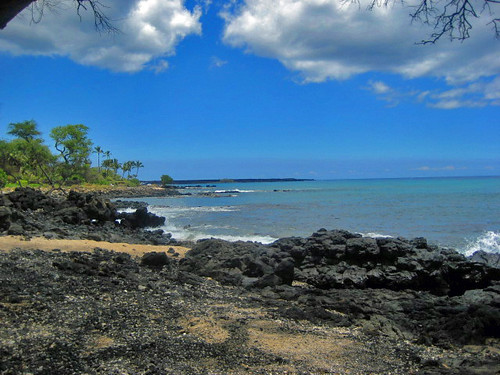
Makena Beach, Maui
The weather here in Hawaii is going through some changes, expressed in terms of lighter winds…and increasing volcanic haze. An approaching cold front, far to the north and northwest of Hawaii, as shown in this satellite image, is moving in our direction. This in turn is pushing a trade wind producing ridge of high pressure southward towards Kauai. The long and short of all this, is that our local winds will become lighter, with a turning of the easterly trade winds, towards the southeast soon. Southeast winds will carry volcanic haze up from the Big Island, over much of the rest of the Aloha state during the next couple of days.
As the trade winds give way to lighter southeast winds, we will move into what is called a convective weather pattern. This usually manifests as clear, somewhat cooler than normal mornings. As the daytime heating occurs, we find afternoon clouds congregating over and around the mountains. These cumulus clouds can provide interior showers, which at times spread down towards the coasts at times. This will start to happen as a autumn cold front, still far away, moves in our direction. It may take until the weekend for this frontal cloud band to arrive…which could bring a more widespread rainfall event then.
I am back from my nearly one month long vacation to the mainland, obviously. I had a wonderful time, without a doubt! I flew back in to the Kahului, Maui airport Monday evening, and was immediately whisked upcountry to Kula, by my next door neighbor. You can check out the details of my vacation adventures by going to the Archived Narratives page…and click on the second one labeled Vacation Report. I went down to Baldwin Beach for a walk and a swim with my neighbors, then on to the health food store, for provisions to get me through the rest of this work week. The beach was sunny to partly cloudy, and rather breezy, but nice. The water was warm, and it was so great to be back in the islands, where the beach is still very user friendly. It’s Veteran’s Day, and as a drafted Vietnam vet, my heart goes out to all those men and women who fell during the war, and to all those that are still alive now I strongly feel that participating in that experience of a life time, for me personally, is now almost beyond description. I rarely speak of it, perhaps most notably on this website once a year. I’ll be back very early Wednesday morning with your next new weather narrative update from paradise. For those of you who have been waiting for my tv weather show to return, it will be on the air again Wednesday morning. Aloha for now…Glenn.